
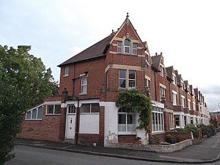
Juxon Street is a street in the north of Jericho, an inner suburb of Oxford, England. [1] [2]
Juxon Street is a street in the north of Jericho, an inner suburb of Oxford, England. [1] [2]
To the east is a junction with Walton Street. To the north are St Sepulchre's Cemetery, Lucy's Eagle Ironworks (now residential), and beyond that Walton Well Road. To the west is the Oxford Canal and beyond that the Castle Mill Stream. To the south is most of the rest of the suburb of Jericho and central Oxford.
Previously this area was part of the Walton Manor farm owned by St John's College, Oxford. [1] The farm was sold the site was unoccupied until 1860 when the college architect, William Wilkinson, was commissioned to lay out the northern part of the estate. The street was named after William Juxon, who was President of St John's College from 1621 to 1633. He was also the Bishop of London and the Archbishop of Canterbury.
Building began in Juxon Street in 1876. [1] The houses were designed to provide small homes for middle-class families. Much of the north side of the street was bought by Lucy's Eagle Ironworks also just to the north to house its staff. Many of the houses have also been for rented to students. Some houses at the west end of the street were demolished and flats was constructed in their place. It is now a popular inner-city residential street with high prices and rents in the area. [3]
There used to be a ferry (with ferry house) and coal wharfs at the end of Juxon Street. [4]
Juxon Street features in the 2003 book Lyra's Oxford by Philip Pullman. Lyra visits the character Sebastian Makepeace who lives on the north side of Juxon Street in a house at the end of the street near the Eagle Ironworks and the Oxford Canal. [5]


St John's College is a constituent college of the University of Oxford. Founded as a men's college in 1555, it has been coeducational since 1979. Its founder, Sir Thomas White, intended to provide a source of educated Roman Catholic clerics to support the Counter-Reformation under Queen Mary.

William Juxon was an English churchman, Bishop of London from 1633 to 1646 and Archbishop of Canterbury from 1660 until his death.

St Stephen's House is an Anglican theological college in Oxford, England. From 2003 to 2023 it was a permanent private hall of the University of Oxford.
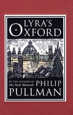
Lyra's Oxford is a 2003 novella by Philip Pullman depicting an episode involving the heroine of His Dark Materials, Pullman's best-selling trilogy. Lyra's Oxford is set when Lyra Belacqua is 15, two years after the end of the trilogy.

Jericho is an historic suburb of the English city of Oxford. It consists of the streets bounded by the Oxford Canal, Worcester College, Walton Street and Walton Well Road. Located outside the old city wall, it was originally a place for travellers to rest if they had reached the city after the gates had closed. The name Jericho may have been adopted to signify this 'remote place' outside the wall. As of February 2021, the population of Jericho and Osney wards was 6,995.

Walton Street is on the eastern edge of the Jericho district of central Oxford, England.

St Sepulchre's Cemetery is a former cemetery located on Walton Street, Jericho, central Oxford, England.
Canterbury Road is a road in North Oxford, England. It runs between Woodstock Road to the west and Banbury Road to the east. Winchester Road leads south from halfway along Canterbury Road, linking with Bevington Road that runs parallel to the south. Also to the south are North Parade and Church Walk.
Lucy Group Ltd, formerly W. Lucy & Co. Ltd, is a privately owned international group headquartered in Oxford, England. The company's origins date back more than 200 years when its principal business was manufacturing metal castings. Since then the business has evolved and steadily expanded into a group comprising four distinct business units. The group operates in 8 countries, from 16 locations, employing over 1,200 people.
The Eagle Ironworks was an ironworks owned by W. Lucy & Co. on the Oxford Canal in Jericho, Oxford, England. William Carter founded the works in 1812 with a shop in the High Street and moved it to its site beside the canal in 1825. It was on Walton Well Road at the northern end of Walton Street and backed onto St Sepulchre's Cemetery. The works ceased production in 2005, was demolished in 2007 and has since been redeveloped, mainly with apartments.
Walton Manor is a residential suburb in Oxford, England. It is north of Jericho and the Radcliffe Observatory Quarter and forms part of North Oxford. The street layout and many of the area's buildings date from the mid-19th century. It was developed on land belonging to St John's College, Oxford.
The Oxford-Man Institute of Quantitative Finance is an interdisciplinary research institute of the University of Oxford, England. The institute was co-founded in June 2007 with Man Group plc. It brings together faculty, post-docs and students throughout the university interested in research into the quantitative finance applications of machine learning and data analytics.
This article covers the fictional locations in the His Dark Materials trilogy and related works by Philip Pullman.

Park End Street is a street in central Oxford, England, to the west of the centre of the city, close to the railway station at its western end.
Frenchay Road is a residential road in Walton Manor, North Oxford, England.

Walton Well Road is a road, about 400 metres long, near the centre of Oxford, England. It provides a link from central Oxford to Port Meadow.
Southmoor Road is a residential road in Walton Manor, north Oxford, England.

Longworth Road is a residential road in Walton Manor, North Oxford, England.
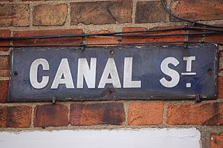
Canal Street is a residential street in Jericho, an inner suburb of Oxford, England, northwest of the city centre.

Great Clarendon Street is one of the principal thoroughfares of the Jericho district of Oxford, England, an inner suburb northwest of the centre of the city.
51°45′38″N1°16′07″W / 51.760503°N 1.268676°W
| | This Oxfordshire location article is a stub. You can help Wikipedia by expanding it. |