Great Colonnade at Palmyra

Last updated
Great Colonnade at Palmyra
Palmyra, Syria - 2.jpg
Overview of the Great Colonnade
Syria adm location map.svg
Archaeological site icon (red).svg
Shown within Syria
Location Palmyra, Syria
Coordinates 34°33′02″N38°16′07″E / 34.5505°N 38.2687°E / 34.5505; 38.2687
Type Colonnade
Length1,200 metres (3,900 ft)
History
Periods Roman, Palmyrene
Site notes
Conditionrestored
OwnershipPublic
Public accessInaccessible (in a war zone)
TypeCultural
Criteriai, ii, iv
Designated1980 (4th session)
Part ofSite of Palmyra
Reference no. 23
Region Arab States
Endangered 2013–present

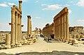
The Great Colonnade at Palmyra was the main colonnaded avenue in the ancient city of Palmyra in the Syrian Desert. The colonnade was built in several stages during the second and third century CE and stretched for more than a kilometer (approximately .75 miles). It linked the Temple of Bel, in the southeastern end of the city, to the West Gate and the Funerary Temple in the northwestern part.

Contents

The colonnade was damaged during the Syrian Civil War, especially when Palmyra was occupied by the Islamic State of Iraq and the Levant from May 2015 to March 2016. However, large parts of it are still intact.[ citation needed ]

Overview

The colonnade consists of three sections that were built separately over the course of the second and third century CE. The western stretch of the colonnade is the oldest and started at the West Gate near the Funerary Temple. [1] The eastern section stretched from the Monumental Arch in the center of the town to the entrance of the Temple of Bel. [2] The middle section was built last to connect the two separate colonnades. It met the western stretch at the Great Tetrapylon, and the eastern stretch at the Monumental Arch. [3]

Western section

The western colonnade was the first section to be built. Inscriptions found on some columns confirm that works started before 158 CE. [1] The straight avenue ran in northwest-southeast direction and stretched for 500 metres (1,600 ft), the longest of the three sectors. [4] The main avenue's width was 11.7 metres (38 ft) while the side streets were 7 metres (23 ft) in width. [5] The colonnade's western terminus, the West Gate, was built in the late second-century CE. The avenue also connected in a right angle to the Transverse Colonnade [3] which stretched to the Damascus Gate in the south. [6]

Eastern section

The eastern sector of the Great Colonnade started at the Monumental Arch and stretched in a northwest-southeast direction towards the propylaea of the Temple of Bel. Work on the colonnade started after the completion of the propylaea in 175 CE and continued through the beginning of the third-century CE. [2] This section is the widest of the Great Colonnade with a uniform width of 22.7 metres (74 ft) for the main street and 6.7 metres (22 ft) for the sidewalks. [5] A corner of the temenos of the Temple of Nebu was demolished to allow the colonnade an uninterrupted line of sight towards the Monumental Arch from the west and a wider access to the section leading to the Temple of Bel. A nymphaeum was later added to the eastern colonnade between the Bel and Nebu temples. [2]

Middle section

The Great Colonnade and the Monumental Arch. PALMYRA Arco di Trionfo - GAR - 6-095.jpg
The Great Colonnade and the Monumental Arch.

The middle colonnade, stretching from east to west, was constructed to connect the two earlier colonnades. Work on the central avenue began from the Monumental Arch, where it met the eastern colonnade, sometime in the early third-century CE. The section stretched until the Great Tetrapylon where it met the western colonnade in an oval plaza. The central colonnade also incorporated the portico of the baths. The central section of the Great Colonnade became the most important with several civic buildings clustered around it, including the caesareum, the theatre, the baths and the Temple of Nebu. [3] The width of the main street varies from 14 metres (46 ft) at its widest near the tetrapylon, to 10 metres (33 ft) when it reaches the Monumental Arch. The sidewalks also vary in width between 6.3–7 metres (21–23 ft) for the northern sidewalk and 6.8–8.95 metres (22.3–29.4 ft) for the southern one. [5]

Architecture and significance

A bracket fixed on one of the columns of the colonnade Column bracket, Palmyra, Syria.jpg
A bracket fixed on one of the columns of the colonnade

The colonnade's early columns, especially in the western stretch, were built using the classical opus emplectum building technique. The columns consisted of six to eight short sections. [1] This technique was gradually replaced, from the 220s, by what historian Marek Barański termed opus Palmyrenum. [5] The newer technique, seen in the middle and eastern stretches of the colonnade, utilized three long segments instead of the short drums. [1] The technique allowed for significantly faster construction at the time. [5]

The Corinthian columns were fitted with decorated brackets that bore dedicatory inscriptions. [7] The brackets were used to hold bronze statues of important figures. [4] Dedicatory inscriptions to Zenobia and Odaenathus dating to between 257 and 267 were discovered on columns set up in front of the theatre. [3]

See also

Related Research Articles

<span class="mw-page-title-main">Dura-Europos</span> Ancient Syrian city

Dura-Europos was a Hellenistic, Parthian, and Roman border city built on an escarpment 90 metres above the southwestern bank of the Euphrates river. It is located near the village of Salhiyé, in present-day Syria. Dura-Europos was founded around 300 BC by Seleucus I Nicator, who founded the Seleucid Empire as one of the Diadochi of Alexander the Great. In 113 BC, Parthians conquered the city, and held it, with one brief Roman intermission, until 165 AD. Under Parthian rule, it became an important provincial administrative centre. The Romans decisively captured Dura-Europos in 165 AD and greatly enlarged it as their easternmost stronghold in Mesopotamia, until it was captured by the Sasanian Empire after a siege in 256–57 AD. Its population was deported, and the abandoned city eventually became covered by sand and mud and disappeared from sight.

<span class="mw-page-title-main">Cardo</span> North–south street in ancient Roman cities

A cardo was a north–south street in Ancient Roman cities and military camps as an integral component of city planning. The cardo maximus, or most often the cardo, was the main or central north–south-oriented street.

<span class="mw-page-title-main">Serapeum</span> Temple dedicated to Serapis

A serapeum is a temple or other religious institution dedicated to the syncretic Greco-Egyptian deity Serapis, who combined aspects of Osiris and Apis in a humanized form that was accepted by the Ptolemaic Greeks of Alexandria. There were several such religious centers, each of which was a serapeion or, in its Latinized form, a serapeum. An Egyptian name for the temple of Osiris-Apis was Pr-Wsỉr-Ḥp "House of Osiris-Apis".

Arch of Hadrian (Athens)

The Arch of Hadrian, most commonly known in Greek as Hadrian's Gate, is a monumental gateway resembling—in some respects—a Roman triumphal arch. It spanned an ancient road from the center of Athens, Greece, to the complex of structures on the eastern side of the city that included the Temple of Olympian Zeus.

Victor Emmanuel II Monument Building in Rome, Italy

The Victor Emmanuel II National Monument, also known as Vittoriano or Altare della Patria, is a large national monument built between 1885 and 1935 to honour Victor Emmanuel II, the first king of a unified Italy, in Rome, Italy. It occupies a site between the Piazza Venezia and the Capitoline Hill. The monument was realized by Giuseppe Sacconi.

Aššur-rabi II, inscribed maš-šur-GAL-bi, "(the god) Aššur is great," was king of Assyria 1012–972 BC. Despite his lengthy reign, one of the longest of the Assyrian monarchs, his tenure seems to have been an unhappy one judging by the scanty and laconic references to his setbacks from later sources.

<span class="mw-page-title-main">Heraion of Samos</span>

The Heraion of Samos was a large sanctuary to the goddess Hera, on the island of Samos, Greece, 6 km southwest of the ancient city of Samos. It was located in the low, marshy basin of the Imbrasos river, near where it enters the sea. The late Archaic temple in the sanctuary was the first of the gigantic free-standing Ionic temples, but its predecessors at this site reached back to the Geometric Period of the 8th century BC, or earlier. The site of temple's ruins, with its sole standing column, was designated a joint UNESCO World Heritage Site, along with the nearby Pythagoreion in 1992.

Apamea, Syria Ancient city in Al-Suqaylabiyah, Syria

Apamea, on the right bank of the Orontes River, was an ancient Greek and Roman city. It was the capital of Apamene under the Macedonians, became the capital and Metropolitan Archbishopric of late Roman province Syria Secunda, again in the crusader period.

Laodicea in Syria

Laodicea was a port city and an important colonia of the Roman Empire in ancient Syria, located near the modern city of Latakia. It was also called Laodicea in Syria or Laodicea ad mare. For a short period of time under Septimius Severus, it became the capital of Roman Syria, and subsequently, it became the capital of the Eastern Roman province of Theodorias from 528 AD until 637 AD.

<span class="mw-page-title-main">Temple of Bel</span> Ruins of an ancient temple in Palmyra, Syria

The Temple of Bel, sometimes also referred to as the "Temple of Baal", was an ancient temple located in Palmyra, Syria. The temple, consecrated to the Mesopotamian god Bel, worshipped at Palmyra in triad with the lunar god Aglibol and the sun god Yarhibol, formed the center of religious life in Palmyra and was dedicated in AD 32. The temple would have been closed during the persecution of pagans in the late Roman Empire in a campaign against the temples of the East made by Maternus Cynegius, Praetorian Prefect of Oriens, between 25 May 385 to 19 March 388. Its ruins were considered among the best preserved at Palmyra, until they were further destroyed by the Islamic State of Iraq and Syria in August 2015. The arched main entrance into the temple is still intact, as well as its exterior walls and fortified gate.

Robinsons Arch Monumental staircase in Jerusalem

Robinson's Arch is the name given to a monumental staircase carried by an unusually wide stone arch, which once stood at the southwestern corner of the Temple Mount. It was built as part of the expansion of the Second Temple initiated by Herod the Great at the end of the 1st century BCE. Recent findings suggest that it may not have been completed until at least 20 years after his death. The massive stone span was constructed along with the retaining walls of the Temple Mount. It carried traffic up from ancient Jerusalem's Lower Market area and over the Tyropoeon street to the Royal Stoa complex on the esplanade of the Mount. The overpass was destroyed during the First Jewish–Roman War, only a few decades after its completion.

<span class="mw-page-title-main">Royal Stoa (Jerusalem)</span> Ancient basilica constructed by Herod the Great

The Royal Stoa was an ancient basilica constructed by Herod the Great during his renovation of the Temple Mount at the end of the first century BCE. Probably Herod's most magnificent secular construction, the three-aisled structure was described by Josephus as deserving "to be mentioned better than any other under the sun." A center of public and commercial activity, the Royal Stoa was the likely location of Jesus' cleansing of the Temple recounted in the New Testament. The Royal Stoa overlooked Jerusalem's residential and commercial quarters, and at its southwestern corner was the place from which a ram's horn was blown to announce the start of holy days.

<span class="mw-page-title-main">Roman Theatre at Palmyra</span> 2nd-century Roman theatre in Syria

The Roman Theatre at Palmyra is a Roman theatre in ancient Palmyra in the Syrian Desert. The unfinished theatre dates back to the second-century CE Severan period. The theatre's remains have since been restored. It was occupied by the Islamic State of Iraq and the Levant (ISIL) in May 2015 and recaptured by the government forces in March 2016 with the support of Russian airstrikes.

<span class="mw-page-title-main">Camp of Diocletian</span>

The Camp of Diocletian was a Roman military complex, or castra, built in the ancient city of Palmyra in the Syrian Desert. The complex was built under the Roman Emperor Diocletian in the late third-century CE and served as the military headquarters for the Legio I Illyricorum.

Great Colonnade at Apamea

The Great Colonnade at Apamea was the main colonnaded avenue of the ancient city of Apamea in the Orontes River valley in northwestern Syria. It was built in the second century CE after Apamea's devastation in the 115 earthquake. The avenue, which runs for nearly 2 kilometres (1.2 mi), made up the city's north-south axis, or the cardo maximus. The monumental colonnade is among the longest and most famous in the Roman world.

<span class="mw-page-title-main">Palmyra</span> Ancient city in Homs Governorate, Syria

Palmyra is an ancient city in present-day Homs Governorate, Syria. Archaeological finds date back to the Neolithic period, and documents first mention the city in the early second millennium BC. Palmyra changed hands on a number of occasions between different empires before becoming a subject of the Roman Empire in the first century AD.

<span class="mw-page-title-main">Temple of Baalshamin</span>

The Temple of Baalshamin was an ancient temple in the city of Palmyra, Syria, dedicated to the Canaanite sky deity Baalshamin. The temple's earliest phase dates to the late 2nd century BC; its altar was built in 115 AD, and the temple was substantially rebuilt in 131 AD. The temple would have been closed during the persecution of pagans in the late Roman Empire in a campaign against the temples of the East made by Maternus Cynegius, Praetorian Prefect of Oriens, between 25 May 385 to 19 March 388. With the spreading of Christianity in the region in the 5th century AD, the temple was converted to a church.

<span class="mw-page-title-main">Monumental Arch of Palmyra</span> Ornamental arch in Palmyra, Syria

The Monumental Arch, also called the Arch of Triumph or the Arch of Septimius Severus, was a Roman ornamental archway in Palmyra, Syria. It was built in the 3rd century during the reign of emperor Septimius Severus. Its ruins later became one of the main attractions of Palmyra until it was officially destroyed by the ISIS in 2015. Most of its stonework still survives and there are plans to rebuild it using anastylosis.

#NEWPALMYRA is an effort to reconstruct the ancient city of Palmyra as an immersive virtual environment, based on archaeological and other clues. The project was started from photos Bassel Khartabil had been taking of Palmyra since 2005. He began building models of the ancient city, with support from Al Aous Publishers. In 2012, Khartabil was arrested, and the original project and open source files were lost. Barry Threw took over as director of the project, renamed #NEWPALMYRA, and a community of developers, modelers, and archaeologists began collaborating to model, restore, and later recreate from scratch those historical structures captured on film and camera.

Propylaia (Acropolis of Athens)

The Propylaia is the classical Greek Doric building complex that functioned as the monumental ceremonial gateway to the Acropolis of Athens. Built between 437 and 432 BCE as a part of the Periklean Building Program, it was the last in a series of gatehouses built on the citadel. Its architect was Mnesikles, his only known building. It is evident from traces left on the extant building that the plan for the Propylaia evolved considerably during its construction, and that the project was ultimately abandoned in an unfinished state.

References

Notes

  1. 1 2 3 4 Barański, 1995, p. 39.
  2. 1 2 3 Barański, 1995, p. 43.
  3. 1 2 3 4 Barański, 1995, p. 45.
  4. 1 2 Butcher, 2003, p. 246.
  5. 1 2 3 4 5 Barański, 1995, p. 41.
  6. Butcher, 2003, p. 245.
  7. Barański, 1995, p. 37.

Bibliography

  • Barański, Marek (1995). "The Great Colonade of Palmyra Reconsidered". ARAM Periodical. ARAM Society for Syro-Mesopotamian Studies. 7 (1): 37–46. doi:10.2143/ARAM.7.1.2002216.
  • Butcher, Kevin (2003). Roman Syria: And the Near East. Getty Publications. ISBN   9780892367153.