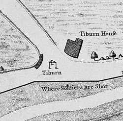
Tyburn was a manor (estate) in the county of Middlesex, one of two which were served by the parish of Marylebone.
The River Fleet is the largest of London's subterranean rivers, all of which today contain foul water for treatment. It has been used as a sewer since the development of Joseph Bazalgette's London sewer system in the mid 19th century with the water being treated at Beckton Sewage Treatment Works. Its headwaters are two streams on Hampstead Heath, each of which was dammed into a series of ponds—the Hampstead Ponds and the Highgate Ponds—in the 18th century. At the southern edge of Hampstead Heath these descend underground as sewers and join in Camden Town. The waters flow 4 miles (6 km) from the ponds.
Cheapside is a street in the City of London, the historic and modern financial centre of London, which forms part of the A40 London to Fishguard road. It links St. Martin's Le Grand with Poultry. Near its eastern end at Bank junction, where it becomes Poultry, is Mansion House, the Bank of England, and Bank station. To the west is St. Paul's Cathedral, St Paul's tube station and square.

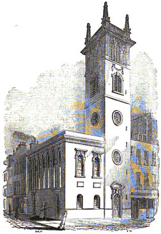
The Church of St Mary-le-Bow is a Church of England parish church in the City of London. Located on Cheapside, one of the city's oldest and most important thoroughfares, the church was founded in 1080 by Lanfranc, Archbishop of Canterbury. Rebuilt several times over the ensuing centuries, the present church is the work of Sir Christopher Wren, widely acknowledged to be one of his finest creations. With its tall spire, it is still a landmark in the City of London, being the third highest of any Wren church, surpassed only by nearby St Paul's Cathedral and St Bride's, Fleet Street. At a cost of over £15,000, it was also his second most expensive, again only surpassed by St Paul's Cathedral.

The Westbourne or Kilburn is a culverted small River Thames tributary in London, rising in Hampstead and Brondesbury Park and which as a drain unites and flows southward through Kilburn and Bayswater to skirt underneath the east of Hyde Park's Serpentine lake then through central Chelsea under Sloane Square. It passes centrally under the south side of Royal Hospital Chelsea's Ranelagh Gardens before discharging into Inner London's old-fashioned, but grandiose combined sewer system, with exceptional discharges into the Inner London Tideway. Since the latter 19th century, the population of its catchment has risen further but to reduce the toll it places on the Beckton Sewage Treatment Works and related bills its narrow basin has been assisted by private soakaways, and public surface water drains. Its depression has been replaced with and adopted as a reliable route for a gravity combined sewer. The formation of the Serpentine relied on the water, a lake with a long, ornate footbridge and various activities associated, which today uses little-polluted water from a great depth.

Tyburn Brook was a small tributary stream to the West Bourne or Westbourne and ran mainly in Hyde Park for a few hundred metres south by south-west. It has lost its catchment to natural drainage into the gravelly topsoil and to surface water, foul and in early Victorian style combined sewers and its small collect, its source remains beneath the earth to feed into a mixture of these. The Serpentine, having been the Westbourne's main showing is now fed by three boreholes instead. It is not to be confused with the much longer Tyburn, Ty Bourne or River Tyburn, but frequently was confused until the early 19th century as both were well west of the walls of the City of London.
The River Tyburn was a stream in London, its main successor sewers emulate its main courses but it resembled the Colne in its county of Middlesex in that it had many distributaries. It ran from South Hampstead, through Marylebone and Mayfair then ran through St James's parish/district and Green Park to meet the tidal Thames at four sites, grouped into pairs. These pairs were near Whitehall Stairs and by Thorney Street, between Millbank Tower and Thames House. Its much smaller cousin the Tyburn Brook was a tributary of the Westbourne, in turn the next Thames tributary.

Conduit current collection is an obsolete system of electric current collection used by some electric tramways, where the power supply was carried in a 'conduit' under the roadway. Modern systems fall under the term ground-level power supply.

The Aqua Appia was the first Roman aqueduct, constructed in 312 BC by the co-censors Gaius Plautius Venox and Appius Claudius Caecus, the same Roman censor who also built the important Via Appia.

The Romans constructed aqueducts throughout their Republic and later Empire, to bring water from outside sources into cities and towns. Aqueduct water supplied public baths, latrines, fountains, and private households; it also supported mining operations, milling, farms, and gardens.

Hobson's Conduit, also called Hobson's Brook, is a watercourse that was built from 1610 to 1614 by Thomas Hobson and others to bring fresh water into the city of Cambridge, England from springs at Nine Wells, a Local Nature Reserve, near the village of Great Shelford. It is now a Scheduled Ancient Monument and historical relic. The watercourse currently runs overground until Cambridge University Botanic Garden and Brookside, where it is at its widest. At the corner of Lensfield Road stands a hexagonal monument to Hobson, which once formed part of the market square fountain, and was moved to this location in 1856, after a fire in the Market. The flow of water runs under Lensfield Road, and subsequently runs along both sides of Trumpington Street in broad gutters towards Peterhouse and St Catharine's College, and also St Andrew's Street. The conduit currently ends at Silver Street.
All Hallows Bread Street was a parish church in the Bread Street ward of the City of London, England. It stood on the east side of Bread Street, on the corner with Watling Street. First mentioned in the 13th century, the church was destroyed in the Great Fire of London in 1666. The church was rebuilt by the office of Sir Christopher Wren and demolished in 1876.

London's water supply infrastructure has developed over the centuries in line with the expansion of London. For much of London's history, private companies supplied fresh water to various parts of London from wells, the River Thames and the River Lea. Further demand prompted new conduits and sources, particularly when the Agricultural and Industrial Revolution caused a boom in London's population and housing.

St. Matthew Friday Street was a church in the City of London located on Friday Street, off Cheapside. Recorded since the 13th century, the church was destroyed in the Great Fire of 1666, then rebuilt by the office of Sir Christopher Wren. The rebuilt church was demolished in 1885.

All Hallows, Honey Lane was a parish church in the City of London, England. Of medieval origin, it was destroyed in the Great Fire of London in 1666 and not rebuilt; the site became part of Honey Lane Market, which was in turn partially cleared to make way for the City of London School in the 19th century. Much of the area was destroyed during the bombing in World War II and has been redeveloped. The name Honey Lane is retained in a nearby walkway.
Peter Morice was a Dutch-born engineer who developed one of the first pumped water supply systems for the City of London. In London, his first pumps were powered by an undershot waterwheel housed in the northernmost arches of London Bridge, spanning the tidal River Thames.

St Michael-le-Querne, also called St Michael ad Bladum, was a parish church in the Farringdon Within Ward in the City of London. It was destroyed in the Great Fire of London of 1666 and not rebuilt. The name is apparently a reference to a quern-stone as there was a corn market in the churchyard.

Lamb's Conduit Street is a street in Holborn in the West End of London. The street takes its name from Lambs Conduit, originally known as the Holborn Conduit, a dam across a tributary of the River Fleet.
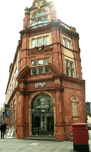
Grays Antique Centre is an antiques centre in Mayfair, London, close to Bond Street station and is better known as Grays Antique Market. Dealers specialise in antiques, jewellery, watches and collectables. The centre is home to nearly 100 dealers on 2 levels.

Stocks Market was a market in central London operating between 1282 and 1737 and for centuries was London's main retail meat and produce market.

