Great Swamp Brook

Last updated

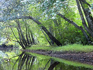
Great Swamp Brook (Great Swamp Branch on federal maps [1] ) is a 9.1-mile-long (14.6 km) [2] tributary of Nescochague Creek in the southern New Jersey Pine Barrens in the United States. [3]

Tributary stream or river that flows into a main stem river or lake

A tributary or affluent is a stream or river that flows into a larger stream or main stem river or a lake. A tributary does not flow directly into a sea or ocean. Tributaries and the main stem river drain the surrounding drainage basin of its surface water and groundwater, leading the water out into an ocean.

Nescochague Creek is a 6.4-mile-long (10.3 km) tributary of the Mullica River in southern New Jersey in the United States. The creek starts just northwest of Hammonton, arcs along the southern boundary of Wharton State Forest, and joins the Mullica River just above County Route 542.

New Jersey State of the United States of America

New Jersey is a state in the Mid-Atlantic and Northeastern regions of the United States. It is located on a peninsula, bordered on the north and east by the state of New York, particularly along the extent of the length of New York City on its western edge; on the east, southeast, and south by the Atlantic Ocean; on the west by the Delaware River and Pennsylvania; and on the southwest by the Delaware Bay and Delaware. New Jersey is the fourth-smallest state by area but the 11th-most populous, with 9 million residents as of 2017, and the most densely populated of the 50 U.S. states; its biggest city is Newark. New Jersey lies completely within the combined statistical areas of New York City and Philadelphia. New Jersey was the second-wealthiest U.S. state by median household income as of 2017.

See also

Related Research Articles

Toms River freshwater river and estuary in Ocean County, New Jersey in the United States

The Toms River is a 41.7-mile-long (67.1 km) freshwater river and estuary in Ocean County, New Jersey in the United States.

The Bass River is a 4.7-mile-long (7.6 km) tributary of the Mullica River in southeastern New Jersey in the United States.

Tuckahoe River (New Jersey) river in the United States of America

The Tuckahoe River is a 27.6-mile-long (44.4 km) blackwater river in southern New Jersey in the United States.

Albertson Brook, also called Albertsons Brook, is the name of Nescochague Creek upstream of the confluence with Great Swamp Brook in the southern New Jersey Pine Barrens in the United States.

Batsto River river in the United States of America

The Batsto River is a 22.9-mile-long (36.9 km) tributary of the Mullica River in the southern New Jersey Pine Barrens in the United States. The river also drains 49.42 square miles of land.

The West Branch Wading River is a 22.7-mile-long (36.5 km) tributary of the Wading River in Burlington County in the southern New Jersey Pine Barrens in the United States.

Friendship Creek is a 9.4-mile-long (15.1 km) tributary of the South Branch Rancocas Creek in southern New Jersey in the United States.

The South Branch Rancocas Creek is a 21.7-mile-long (34.9 km) tributary of Rancocas Creek in Burlington County, New Jersey in the United States. The South Branch Rancocas Creek drains an area of 144 square miles. Much of the upland agriculture within the Rancocas Creek basin lies inside the South Branch Rancocas Creek basin. It is also among the least developed parts of the Rancocas Creek watershed.

The Southwest Branch Rancocas Creek is a 13.8-mile-long (22.2 km) tributary of the South Branch Rancocas Creek in Burlington County, New Jersey in the United States.

The North Branch Rancocas Creek is a 31-mile-long (50 km) tributary of Rancocas Creek in southwestern New Jersey in the United States.

Manantico Creek, spelled Menantico on federal maps, is an 11.1-mile-long (17.9 km) tributary of the Maurice River in Cumberland County, New Jersey in the United States.

Westecunk Creek is an 11.1-mile-long (17.9 km) tributary of Little Egg Harbor in southeastern New Jersey in the United States.

West Creek is a 12.3-mile-long (19.8 km) tributary of Delaware Bay in Cape May County, New Jersey in the United States.

Dennis Creek is an 8.8-mile-long (14.2 km) tributary of Delaware Bay in Cape May County, New Jersey in the United States.

Cedar Swamp Creek is an 8.9-mile-long (14.3 km) tributary of the Tuckahoe River in southeast New Jersey in the United States.

The Hospitality Branch is a 15.8-mile-long (25.4 km) tributary of the Great Egg Harbor River in southeastern New Jersey in the United States.

Bisphams Mill Creek is a 5.9-mile-long (9.5 km) tributary of Greenwood Branch in the southern New Jersey Pine Barrens in the United States.

Pole Bridge Branch is a 12.1-mile-long (19.5 km) tributary of Greenwood Branch in the southern New Jersey Pine Barrens in the United States.

Greenwood Branch is a 9.3-mile-long (15.0 km) tributary of the North Branch Rancocas Creek in the southern New Jersey Pine Barrens in the United States.

References

  1. U.S. Geological Survey Geographic Names Information System: Great Swamp Branch
  2. U.S. Geological Survey. National Hydrography Dataset high-resolution flowline data. The National Map Archived 2012-04-05 at WebCite , accessed April 1, 2011
  3. Gertler, Edward. Garden State Canoeing, Seneca Press, 2002. ISBN   0-9605908-8-9

Coordinates: 39°40′57″N74°44′41″W / 39.68252°N 74.744668°W / 39.68252; -74.744668

Geographic coordinate system Coordinate system

A geographic coordinate system is a coordinate system that enables every location on Earth to be specified by a set of numbers, letters or symbols. The coordinates are often chosen such that one of the numbers represents a vertical position and two or three of the numbers represent a horizontal position; alternatively, a geographic position may be expressed in a combined three-dimensional Cartesian vector. A common choice of coordinates is latitude, longitude and elevation. To specify a location on a plane requires a map projection.