Green's Creek (Ontario)

Last updated
Green's Creek
Greenscreek.jpg
Green's Creek in early spring
Canada Southern Ontario relief location map.jpg
Red pog.svg
Location
Canada
Province Ontario
Municipality Ottawa
Physical characteristics
Sourceconfluence of Borthwick and Ramsey Creeks
  coordinates 45°24′03″N75°35′43″W / 45.40083°N 75.59528°W / 45.40083; -75.59528
Mouth Ottawa River
  coordinates
45°28′29″N75°34′09″W / 45.4747°N 75.5692°W / 45.4747; -75.5692 Coordinates: 45°28′29″N75°34′09″W / 45.4747°N 75.5692°W / 45.4747; -75.5692
Length13.4 km (8.3 mi) [1]
Basin size19.29 km2 (7.45 sq mi) [1]

Green's Creek is a small tributary of the Ottawa River that flows through the community of Gloucester in eastern Ottawa, Ontario, Canada. [2] Among its tributaries are Borthwick Creek, Black Creek, Mud Creek, and Ramsay Creek, all of which spring in the Mer Bleue bog. [1]

Contents

Geography

The creek was formed approximately 10,000 years ago at the end of the Wisconsin Glaciation and the retreat of the Champlain Sea from the Ottawa Valley. Currently it starts at the confluence of Borthwick and Ramsey Creeks just west of the Walkley Road off-ramp from Highway 417 and flows 13.4 kilometres (8+14 miles) to the Ottawa River. From the meeting of its two main tributaries, Borthwick Creek runs eastwards for about four kilometres (2+12 miles) while Ramsey Creek proceeds southwards for approximately 10 kilometres (6 miles). Together these three creeks, and a few smaller streams including Black, Mud and McEwan Creeks, drain approximately 53 square kilometres (20 sq. mi.) – an area larger than the four smallest countries in the world combined.

There is a large area of silver maple swamp where it enters the Ottawa River; this is one of the most important wetland complexes along the south shore of the Ottawa River. Rare species include the only population of the provincially rare pinedrops (Pterospora andromeda) in the region, and the only regional population of witch-hazel (Hammamelis virginiana). The area is conserved as part of the Ottawa Greenbelt and 5.5 kilometres (3+12 miles) of walking trails have been maintained as part of the Green's Creek Valley conservation area.

Green's Creek is also geologically significant for its fine assemblage of fossil fish dating from the era of the Champlain Sea. [3]

Geology

It has cut deeply into sediments of the Champlain Sea, producing a complex mixture of forest types, from upland oak and pine to floodplain forest. As a consequence there are nearly 500 species of plants known from the area. [4]

The surface geology of the creek bed is 84 per cent clay, 8 per cent bedrock, 6 per cent sand and 2 per cent diamicton.

History

While there is no archeological evidence of the First Nations occupying the lands around Green’s Creek there is evidence of human habitation along what was the southwestern shore of the Champlain Sea near present day Perth as long as 11,000 years ago. It is likely that the area around Blackburn Hamlet was first used by humans around 10,500 years ago when bands from the late-paleo period began to hunt the forests that were beginning to take root after the end of glaciation and the retreat of the sea. From that time onwards the area fell within the traditional territory of the Anishinabe Algonquin people. Immediately prior to European contact the creek was almost certainly being used by the Weskarini band who traditionally occupied the South Nation River watershed.

However, by the 1620s the Weskarini were facing extreme pressure from the Iroquois Confederacy that was expanding northwards from New York State. Armed with Dutch firearms the Iroquois drove them out of the lower Ottawa Valley by the spring of 1642 and by 1650 even the Algonquin in the upper Ottawa Valley had been removed from their homelands. For most of the next 200 years trappers, traders and the famed coureur des bois travelled up and down the Ottawa River until the first European settlements in the area took root after 1800.

While Samuel De Champlain’s early exploration of the Ottawa River is generally well known, it was in fact his protégé, Étienne Brulé, who was the first European to pass by the mouth of Green’s Creek in 1610. Although Gloucester Township was first surveyed in 1792, it was not until 1812 that Braddish Billings became its first permanent resident and it seems that the first settlements around Green’s Creek were established sometime around the early 1830s. At the time of the first agricultural clearances, the land around the creek was still covered with large stands of red pine and oak trees and these were gradually cleared in the 1840s, 1850s and 1860s as squared timbers were cut on the tablelands above the creek and floated downstream in the spring run-off. One early account described logs up to 60 feet long, and 18 inches in diameter moving down the creek in their water to the Ottawa River. [5] By the 1860s most of the land along the creek had been settled and many farms lined its banks including those owned by the Barnes, Kenney, Hopkins and Presley families although many of the surveyed lots away from the creek and Ottawa River still remained unassigned. Despite the clearing of the forests there was a sawmill on the upper end of the creek in the 1860s owned and operated by Prosper Oliver, who dammed the water to power his saws. Later, an 1880 map of Gloucester Township showed a different sawmill located at the mouth of the creek on the land of William Mosgrove, and by some accounts that industry remained in operation until the early 1900s.

Also, by the 1860s many of the main roads that are still in use today had been roughed out. Both Montreal Road and Navan Road were in place, and Innes Road had been extended east from Cyrville Road past Green’s Creek (although not as far as Blackburn Hamlet). The oldest of these thoroughfares, Montreal Road (then known as the King’s Road), was run through Gloucester Township in 1850. Initially a small ferry existed to carry passengers and freight across the creek, charging users between 10 and 20 cents on their way between Bytown and Orléans, Ontario. By the early 1860s a bridge had been constructed and a toll booth on the west side of the creek was operated by James Coombs, although by 1880 it appears that the tollgate had been moved to the east side of the bridge. Somewhat incredibly, there is even an account of a steamboat being seen fully two miles upstream of what is now Montreal Road in the 1850s. [6]

At the start of the 1860s the west side of Green’s Creek at Montreal Road became the site of an important hotel and recreational area. The 1863 map of Carleton County shows a hotel owned by Joseph Lafleur near the location of the present-day Montreal Road interchange on Highway 174. By the 1870s this had become the Victoria Sulphur Springs Hotel owned by H.F. Brading and E.W. Hillman. Like other famed mineral springs such as those at Carlsbad Springs people came to this hotel to consume and bathe in the mineral rich waters. The spring, which was situated on the west bank of Green’s Creek just upstream from Montreal Road had a flow rate of 250 gallons per hour and contained particularly high levels of hydrogen sulphide and methane. Patrons to this hotel could purchase sulphur baths for 50 cents each, or a dozen for $5.00. They could also enjoy the adjacent Dominion Trotting Park – a horse racing track. It is not known when this facility shut down, but it was “in ruins” by 1917 and an aerial photograph of the site in 1928 shows no sign of it. Further south, near the current intersection of Andersen and Ridge Roads the Borthwick Mineral Springs were another important resource. While there was no hotel located at these springs the water was so widely known that a medical dictionary from had the following entry; “Borthwick Mineral Springs, Canada. Indo-bromated saline waters, used internally.” In the early 1890s both of these springs were listed as being amongst the largest producers of bottled mineral water in Canada.

In addition to the hotel at the Victoria Sulphur Springs there was also an inn located in Hiawatha Park near the current location of the Residence Saint-Louis. Founded as a summer resort called Besserer’s Grove in the early 1850s it remained a popular destination for day-trippers from Ottawa for many years. Nearby, Besserer’s Wharf acted as a port of call for the Ottawa River steamer “Empress” and families from the city would come out on weekends for a country getaway. An advertisement in the Ottawa Journal from 1896 promised as a pleasant place for picnic parties where visitors could depend upon “good food at reasonable prices.”

Green’s Creek is also well known for the small mineral concretions containing the remains of fresh and saltwater marine life that can be found along its shores. Green’s Creek is well-known in the geological and fossil collecting world due to the presence of smooth nodular formations that were commonly found from the mouth of the creek and along the south shore of the Ottawa River as far as Hiawatha Park. Specimens up to 10,000 years old containing the remains of near complete fish skeletons, ancient whale and seal bones and numerous smaller marine and terrestrial fauna have all been found along the shores of Green’s Creek. It is the only place in central Canada that many samples have been found and is one of only two locations where starfish remains from the Champlain Sea have been identified (the other being near Montreal). These deposits were well known to the early settlers of the region and at the time hundreds of them could be collected over the course of a few days. Enterprising businesses even sold these smooth, kidney shaped rocks to tourists as places such as Besserer’s Wharf.

Ecology

Despite being a largely urban stream Green's Creek has an impressive level of biodiversity. On the land, mammals such as beaver, muskrat, coyotes, chipmunks, racoons, skunks, foxes, deer and even the occasional moose can be found along its banks. Almost 50 species of fish have been observed within the creek including; brook stickleback, pumpkinseed, channel catfish, rock bass, largemouth bass, common carp, walleye, northern pike and yellow perch.

Land use surrounding the creek is characterized as follows; 53% urban use, 19% forest, 12% agriculture, 12% meadow, 2% wetland and 1% each water and "rural."


See also

Related Research Articles

<span class="mw-page-title-main">Rideau River</span> River in Ontario, Canada

The Rideau River is a river in Eastern Ontario, Canada. The river flows north from Upper Rideau Lake and empties into the Ottawa River at the Rideau Falls in Ottawa, Ontario. Its length is 146 kilometres (91 mi).

<span class="mw-page-title-main">Lake Saint Pierre</span> Body of water

Lake Saint Pierre is a lake in Quebec, Canada, a widening of the Saint Lawrence River between Sorel-Tracy and Trois-Rivières. It is located downstream, and northeast, of Montreal; and upstream, and southwest, of Quebec City. The end of the lake delimits the beginning of the estuary of Saint Lawrence.

<span class="mw-page-title-main">Ottawa Valley</span> Valley in Ontario and Quebec in Canada

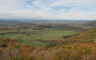
The Ottawa Valley is the valley of the Ottawa River, along the boundary between Eastern Ontario and the Outaouais, Quebec, Canada. The valley is the transition between the Saint Lawrence Lowlands and the Canadian Shield. Because of the surrounding shield, the valley is narrow at its western end and then becomes increasingly wide as it progresses eastward. The underlying geophysical structure is the Ottawa-Bonnechere Graben. Approximately 1.3 million people reside in the valley, around 80% of whom reside in Ottawa. The total area of the Ottawa Valley is 2.4 million ha. The National Capital Region area has just over 1.4 million inhabitants in both provinces.

<span class="mw-page-title-main">Carlsbad Springs, Ontario</span> Rural community in Ottawa

Carlsbad Springs is a rural community on Bear Brook in Cumberland Ward in Ottawa, Ontario, Canada; Prior to amalgamation in 2001, the community was on the border between Gloucester and Cumberland. According to the Canada 2011 Census, the population of the surrounding area is 916.

<span class="mw-page-title-main">Greenbelt (Ottawa)</span> Green belt surrounding the city of Ottawa, Ontario

The Greenbelt is a 203.5-square-kilometre (78.6 sq mi) protected green belt traversing Ottawa, Ontario, Canada. It includes green space, forests, farms, and wetlands from Shirleys Bay in the west and to Green's Creek in the east. It is the largest publicly owned green belt in the world and the most ecologically diverse area in Eastern Ontario. The National Capital Commission (NCC) owns and manages 149.5 square kilometres (57.7 sq mi), and the rest is held by other federal government departments and private interests. Real estate development within the Greenbelt is strictly controlled.

<span class="mw-page-title-main">Mattawa River</span> River in Ontario, Canada

The Mattawa River is a river in central Ontario, Canada. It flows east from Trout Lake east of North Bay and enters the Ottawa River at the town of Mattawa. Counting from the head of Trout Lake, it is 76 kilometres (47 mi) long. The river's name comes from the Algonquin word for "meeting of waterways".

<span class="mw-page-title-main">Orléans (electoral district)</span> Federal electoral district in Ontario, Canada

Orléans is a federal electoral district in Ottawa, Ontario, Canada, that has been represented in the House of Commons of Canada since 1988.

<span class="mw-page-title-main">Beacon Hill, Ottawa</span> Neighbourhood in Ottawa, Ontario, Canada

Beacon Hill is a neighbourhood located in Beacon Hill-Cyrville Ward in the east end of Ottawa, Ontario, Canada. Beacon Hill was a part of the City of Gloucester until it was amalgamated with the new city of Ottawa in 2001.

<span class="mw-page-title-main">Orleans, Ontario</span> Suburb of Ottawa, Ontario, Canada

Orleans is a suburb of Ottawa, Ontario, Canada. It is located in the east end of the city along the Ottawa River, about 16 km (10 mi) from Downtown Ottawa. The Canada 2021 Census determined that Orléans' population was 125,937. Prior to being amalgamated into Ottawa in 2001, the community of Orléans was spread over two municipal jurisdictions, the eastern portion being in the pre-amalgamation City of Cumberland, the western portion in the City of Gloucester. According to the 2021 census, 75,453 people lived in the Cumberland portion of Orleans, while 50,484 people lived in the Gloucester portion. Today, Orléans spans the municipal wards of Orléans East-Cumberland, Orléans West-Innes, and Orléans South-Navan. Orléans contains a significant francophone population.

<span class="mw-page-title-main">Mer Bleue Bog</span>

Mer Bleue Bog is a 33.43 km2 (12.91 sq mi) protected area in Gloucester, Ontario, an eastern suburb of Ottawa in Eastern Ontario, Canada. Its main feature is a sphagnum bog that is situated in an ancient channel of the Ottawa River and is a remarkable boreal-like ecosystem normally not found this far south. Stunted black spruce, tamarack, bog rosemary, blueberry, and cottongrass are some of the unusual species that have adapted to the acidic waters of the bog.

<span class="mw-page-title-main">Muskrat Lake</span> Lake in Ontario, Canada

Muskrat Lake is located in the Whitewater Region of Renfrew County, in Ontario, Canada. It is approximately 16 km (9.9 mi) in length, an average of 17.9 m (59 ft) deep but 64 m (210 ft) at its deepest point, and covers an area of 1,219 ha. It is rumored to be home to a legendary lake monster that locals fondly refer to as “Mussie”. The lake currently has over 300 lakefront properties and two privately owned campgrounds surrounding its shores. The town of Cobden is the largest settlement on the lake, with a population slightly over 1,000 people.

<span class="mw-page-title-main">Ottawa Road 174</span> Controlled-access highway in Ottawa

Ottawa Road 174, formerly Ottawa-Carleton Regional Road 174 and commonly referred to as Highway 174, is a city-maintained road in the City of Ottawa which serves the eastern suburbs of Orléans and Cumberland. The four-lane freeway segment between Highway 417/Aviation Parkway junction to Trim Road is also known as the Queensway, in addition the Queensway name continues to be applied to Highway 417 west of that intersection. Although the road continues through the towns of Rockland and Hawkesbury to the Quebec border, the portion east of the Ottawa city boundary is known as Prescott and Russell County Road 17.

The Great Lakes-St. Lawrence Lowlands, or simply St. Lawrence Lowlands, is a physiographic region of Eastern Canada that comprises a section of southern Ontario bounded on the north by the Canadian Shield and by 3 of the Great Lakes — Lake Huron, Lake Erie and Lake Ontario — and extends along the St. Lawrence River to the Strait of Belle Isle and the Atlantic Ocean. The lowlands comprise three sub-regions that were created by intrusions from adjacent physiographic regions — the West Lowland, Central Lowland and East Lowland. The West Lowland includes the Niagara Escarpment, extending from the Niagara River to the Bruce Peninsula and Manitoulin Island. The Central Lowland stretches between the Ottawa River and the St. Lawrence River. The East Lowland includes Anticosti Island, Îles de Mingan, and extends to the Strait of Belle Isle.

<span class="mw-page-title-main">Orléans (provincial electoral district)</span> Provincial electoral district in Ontario, Canada

Orléans is a provincial electoral district in eastern Ontario, Canada. It elects one member to the Legislative Assembly of Ontario. Before the 2018 election, it was known as Ottawa—Orléans.

<span class="mw-page-title-main">Dundas Valley Conservation Area</span>

Dundas Valley Conservation Area is located on the Niagara Escarpment in Dundas, Ontario, a constituent community of Hamilton, Ontario, and is owned and operated by the Hamilton Conservation Authority. Its 40-kilometre trail system provides a connection to the Bruce Trail. The area contains a trailhead of the Hamilton-Brantford-Cambridge Trails, Canada's first fully developed interurban multi-use trail system, which is a part of the Trans Canada Trail.

<span class="mw-page-title-main">White Lake (Ontario)</span> Body of water

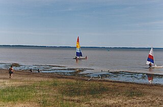
White Lake is a medium-sized lake of Ontario, Canada. It is located in Renfrew County, 60 kilometres (37 mi) west of Ottawa, Ontario near Calabogie to the west and Arnprior to the north. It may be accessed via Highway 417 from Ottawa or Renfrew Country Road 511 from Perth. The town of White Lake lies on the northern shore of the lake.

<span class="mw-page-title-main">Champlain Sea</span>

The Champlain Sea was a prehistoric inlet of the Atlantic Ocean into the North American continent, created by the retreating ice sheets during the closure of the last glacial period. The inlet once included lands in what are now the Canadian provinces of Quebec and Ontario, as well as parts of the American states of New York and Vermont.

The history of Ottawa, capital of Canada, was shaped by events such as the construction of the Rideau Canal, the lumber industry, the choice of Ottawa as the location of Canada's capital, as well as American and European influences and interactions. By 1914, Ottawa's population had surpassed 100,000 and today it is the capital of a G7 country whose metropolitan population exceeds one million.

References

  1. 1 2 3 "Greens Creek 2016 Summary Report" (PDF). Rideau Valley Conservation Authority. City Stream Watch. 2016. Retrieved 21 August 2019.
  2. "Green's Creek". Geographical Names Data Base . Natural Resources Canada . Retrieved 21 August 2019.
  3. McAllister, D.E., C.R. Harrington, S.L. Cumbaa, and C.B. Renaud. 1988. Paleoenvironmental and biogeographic analyses of fossil fishes in peri-Champlain Sea deposits in Eastern Canada. Pp 241-258 in Gadd, N.R. (ed.) The Late Quaternary Development of the Champlain Sea Basin. Geological Association of Canada, Special Paper 36.
  4. Brunton, D.F. 1992. Life Science Areas of Natural and Scientific Interest in Site District 6-12. A Review and Assessment of Significant Natural Areas. Report prepared for Ontario Ministry of Natural Resources, Kemptville, Ontario. p.92-93
  5. Walker, Harry and Olive. Carleton Saga, (Ottawa: The Runge Press, 1968), p. 213.
  6. Walker, p. 213.