Overview
Bytown was located where the Rideau Canal meets the Ottawa River and consisted of two parts centred around the canal, Upper Town and Lower Town. Upper Town, situated to the west of the canal, was situated in the area of the current downtown and Parliament Hill. Lower Town was on the east side of the canal where today's Byward Market and general area of Lower Town still exists. The two areas of town were connected over the Rideau Canal by the Sappers Bridge, constructed in 1827.
The town took its name from John By who, as a lieutenant colonel in the British Royal Engineers, was instrumental in the construction of the canal. [3] The name "Bytown" came about, somewhat as a "jocular reference" during a small dinner party of some officers, and it appears on official correspondence dated 1828. [4]

Joseph Bouchette in the summer of 1828 wrote:
The streets are laid out with much regularity, and of a liberal width that will hereafter contribute to the convenience, salubrity and elegance of the place. The number of houses now built is about 150, most of which are constructed of wood; frequently in a style of neatness and taste that reflects great credit upon the Inhabitants. On the elevated banks of the Bay, the Hospital, an extensive stone building, and three Barracks stand conspicuous; nearly on a level with them, and on the eastern side of the Bay, is the residence of Colonel By, Command Royal Engineer at that Station. [4]
Colonel By laid out the streets of Bytown, a pattern that mostly exists today. Wellington Street, Rideau Street, Sussex and Sparks Street were some of the earliest streets in use. Sappers Bridge actually connected Sparks Street to Rideau Street at that time. Nicholas Sparks owned Bytown's land west of the canal, except for the lands north of Wellington, which were considered "Ordnance" lands. The area east of Bank Street to the canal was acquired by the military and not used for houses for around two decades, after which it was returned to him.
The Ottawa River timber trade spurred the growth of Bytown, and it saw an influx of immigrants, and later entrepreneurs hoping to profit from the squared timber that would be floated down the Ottawa River to Quebec. [5] [6] Bytown had seen some trouble in the early days, first with the Shiners' War in 1835 to 1845, [7] and the Stony Monday Riot in 1849. [8]
Some early buildings that still stand had been erected in Bytown. In 1826, Thomas McKay was contracted to build the commissariat building, [9] now the Bytown Museum. McKay also built Rideau Hall (which has since been expanded), and parts of the Union Bridge connecting LeBreton Flats to Hull. Notre-Dame Cathedral Basilica was also built early on in the developing town. The University of Ottawa had its 1846 origins as a college, and it received its present location in 1856.
 Falls of the Rideau River, at the Ottawa River, 1826 by Thomas Burrowes
 Western and Lesser Fall of the Rideau River; Barrack Hill and Upper Bytown in the left Distance, 1826 by Thomas Burrowes
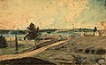 Hull, (Lower Canada), on the Ottawa River; at the Chaudière Falls, 1830 by Thomas Burrowes
 First Eight Locks of the Rideau Canal, the North entrance from the Ottawa River, 1834 by Thomas Burrowes
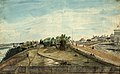 View at the West end of Wellington Street, Upper Bytown, looking east towards Lower Town in 1845 by Thomas Burrowes
 Bytown in 1853. Military Barracks on hill top was occupied by "A" Company of the Royal Canadian Rifle Regiment, presently home to Parliament Hill.


Though administration of Bytown had been conducted by civil authorities since 1828, [10] the town did not become incorporated until much later. Various attempts at incorporation had been initiated since 1845. The Ordnance Department had held lands in the town's core (dividing Upper Town from Lower Town), lands which had been the property of Nicholas Sparks. These lands were considered by many to be blocking economic progress as well as being held for speculative reasons only. When Ordnance eventually returned the lands to Sparks through the Vesting Act, the major obstacle to incorporation was removed. Bytown was initially incorporated on July 28, 1847, and sanctioned by both the Legislative Assembly and the governor, but eventually this was disallowed by the Queen, possibly due to the perceived threat to Ordnance. An act of the Legislative Assembly further facilitated the incorporation of municipalities, and on January 1, 1850, Bytown was incorporated. [11]


