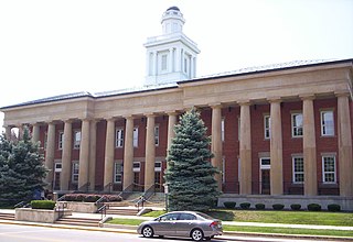
Sandusky County is a county in the U.S. state of Ohio located southeast of the Toledo Metropolitan Area. As of the 2010 census, the population was 60,944. Its county seat is Fremont. The county was formed on February 12, 1820, from portions of Huron County. The name is derived from the Wyandot word meaning "water". The Sandusky River runs diagonally northeast through the county to its mouth on Sandusky Bay. The bay opens into Lake Erie.

Green Springs is a village in Sandusky and Seneca counties in the U.S. state of Ohio. The population was 1,368 at the 2010 census.

The Stillwater River is a 69.3-mile-long (111.5 km) tributary of the Great Miami River in western Ohio in the United States. Via the Great Miami and Ohio rivers, it is part of the Mississippi River watershed.

The Little Miami River is a Class I tributary of the Ohio River that flows 111 miles (179 km) through five counties in southwestern Ohio in the United States. The Little Miami joins the Ohio River east of Cincinnati. It forms parts of the borders between Hamilton and Clermont counties and between Hamilton and Warren counties. The Little Miami River is one of 156 American rivers designated by the U.S. Congress or the Secretary of the Interior as a National Wild and Scenic River and lends its name to the adjacent Little Miami Scenic Trail.
Tinker's Creek, in Cuyahoga, Summit and Portage counties, is the largest tributary of the Cuyahoga River, providing about a third of its flow into Lake Erie.

The Little Beaver Creek is a wild and scenic area in Ohio. The Little Beaver Creek watershed is located primarily in Columbiana County in eastern Ohio, and in portions of Carroll County, Mahoning County, and western Pennsylvania, draining approximately 605 mi² (1,567 km²), of which 503 mi² (1,303 km²) are in Ohio. The watershed in total size covers an area of approximately 510 square miles, with about 80% of this being situated in Ohio. The great majority land in the watershed is privately owned. Within the watershed are roughly 808 miles of linear streams.
Green Spring Run is an 8.9-mile-long (14.3 km) tributary stream of the North Branch Potomac River in Hampshire County in the U.S. state of West Virginia. Green Spring Run rises in Greenwood Hollow north of Springfield and meanders northeast through Green Spring Valley. The South Branch Valley Railroad and Green Spring Road run parallel to the stream. It runs through the community of Green Spring, from which the stream takes its name. From Green Spring, Green Spring Run flows east where it reaches its confluence with the North Branch Potomac shortly before the North Branch joins with the South Branch Potomac River to form the Potomac River.
Carp River is a 40.2-mile-long (64.7 km) river in Chippewa and Mackinac counties in the U.S. state of Michigan. 21.7 miles (34.9 km) of the river were added to the National Wild and Scenic Rivers System in 1992.

Ballville Township is one of the twelve townships of Sandusky County, Ohio, United States. As of the 2000 census, 6,395 people lived in the unincorporated portions of the township.

Green Creek Township is one of the twelve townships of Sandusky County, Ohio, United States. As of the 2000 census, 9,527 people lived in the township, 3,467 of whom lived in the unincorporated portions of the township.

Sandusky Township is one of the twelve townships of Sandusky County, Ohio, United States. As of the 2000 census, 4,087 people lived in the unincorporated portions of the township.
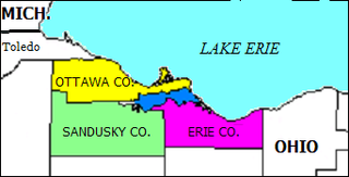
Sandusky Bay is a bay on Lake Erie in northern Ohio, formed at the mouth of the Sandusky River. It was identified as Lac Sandouské on a 1718 French map, with early variations recorded that suggest the name was derived from Native American languages. The Thomas A. Edison Memorial Bridge was constructed across it in the 20th century to connect highways in Erie and Ottawa counties.
Dans Run is a 2.3-mile-long (3.7 km) non-navigable tributary stream of the North Branch Potomac River in Mineral County, West Virginia. Dans Run rises to the east of Patterson Creek Mountain and empties into the North Branch at the community of Dans Run on the old Baltimore & Ohio Railroad. Dans Run Island in the North Branch Potomac, at its confluence with Dans Run, is also named for the small stream.
Brandywine Creek in Crawford County, Ohio is a 6.6-mile-long (10.6 km) tributary of Broken Sword Creek.
Broken Sword Creek in Wyandot County and Crawford County, Ohio is a 37.1-mile-long (59.7 km) tributary of the Sandusky River.
The Ridgeley sandstone is a sandstone or quartzite of Devonian age found in the Appalachian Mountains of Pennsylvania, Maryland, West Virginia, and Virginia, United States. The Ridgeley is fine-grained, siliceous, calcareous in its lower strata, sometimes fossiliferous, and sometimes locally pebbly or conglomeritic. Varying in thickness from 12 to 500 feet, this rock slowly erodes into white quartz sand that often washes or blows away, but sometimes accumulates at large outcrops. When freshly broken, the rock is white, but outcrop surfaces are often stained yellowish by iron oxides.
Wolf Creek is a stream in the U.S. state of Ohio. It is a tributary of the Sandusky River.
Green Creek is an unincorporated community in Sandusky County, in the U.S. state of Ohio.
Tinney is an unincorporated community in Sandusky County, in the U.S. state of Ohio.


