
The Willamette River is a major tributary of the Columbia River, accounting for 12 to 15 percent of the Columbia's flow. The Willamette's main stem is 187 miles (301 km) long, lying entirely in northwestern Oregon in the United States. Flowing northward between the Oregon Coast Range and the Cascade Range, the river and its tributaries form the Willamette Valley, a basin that contains two-thirds of Oregon's population, including the state capital, Salem, and the state's largest city, Portland, which surrounds the Willamette's mouth at the Columbia.

Sweet Home is a city in Linn County, Oregon, United States, with a population of 8,925 at the 2010 census. Built near the site of a prehistoric petrified forest, Sweet Home experienced substantial growth during the construction of the Green Peter and Foster dams in the 1940s. The town's main attraction nowadays is the Cascade mountains through Santiam Pass.

Detroit Lake is a reservoir impounded by the Detroit Dam on the North Santiam River 46 miles (74 km) southeast of Salem, Oregon, United States. The lake is adjacent to Oregon Route 22 near the city of Detroit. This mesotrophic lake stores water for use by the city of Salem and other nearby communities.

The McKenzie River is a 90-mile (145 km) tributary of the Willamette River in western Oregon in the United States. It drains part of the Cascade Range east of Eugene and flows westward into the southernmost end of the Willamette Valley. It is named for Donald McKenzie, a Scottish Canadian fur trader who explored parts of the Pacific Northwest for the Pacific Fur Company in the early 19th century. As of the 21st century, six large dams have been built on the McKenzie and its tributaries.

Foster Reservoir is a reservoir created by Foster Dam on the South Santiam River in the city of Foster, Oregon, United States. The reservoir is approximately 5.6 km (3.5 mi) long and covers approximately 494 ha when full. Primary use of the reservoir is recreation in the summer and flood control in the winter and spring.

Foster Dam is an embankment type rock-fill dam across the South Santiam River near Sweet Home, Oregon, United States.

Fern Ridge Reservoir is a reservoir on the Long Tom River in the U.S. state of Oregon. The reservoir is located approximately 12 miles (19 km) west of Eugene on Oregon Route 126. The reservoir is a U.S. Army Corps of Engineers flood control project encompassing more than 12,000 acres (49 km2) and is a popular site for boating, fishing, and birdwatching.

Applegate Lake is a 988-acre (400 ha) reservoir located in the Rogue River–Siskiyou National Forest about 27 miles (43 km) southwest of Medford in the U.S. state of Oregon. It is 16 miles (26 km) south of Oregon Route 238 along Applegate River Road and slightly north of the Oregon–California border. The lake is an impoundment of the Applegate River about 46 miles (74 km) from its confluence with the Rogue River.

Cougar Dam is a 519-foot (158 m) tall rockfill hydroelectric dam in the U.S. state of Oregon. It has a gated concrete spillway and a powerhouse with two turbines totaling 25 megawatts of electric power.
Lookout Point Lake is a large reservoir on the Middle Fork Willamette River in Lane County, Oregon, United States. It was created in 1953 with the construction of Lookout Point Dam.

Dexter Reservoir is a reservoir in Lane County, in the U.S. state of Oregon. It is about 16 miles (26 km) southeast of Eugene on the Middle Fork Willamette River, immediately downriver from Lookout Point Lake, another reservoir. The communities of Dexter and Lowell are near the lake. Oregon Route 58 follows the lake's southern shore, while Pengra Road parallels the lake's northern shore as far east as Lowell.
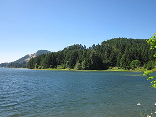
Dorena Reservoir is a reservoir on the Row River in Lane County, Oregon, United States. It is located 6 miles (9.7 km) east of Cottage Grove.

Blue River Reservoir is an artificial impoundment, about 6 miles (10 km) long, of the Blue River in Lane County in the U.S. state of Oregon. The reservoir is about 1 mile (1.6 km) north of Oregon Route 126 in the Willamette National Forest about 45 miles (72 km) east of Eugene.

Hills Creek Dam is a dam about 4 miles (6.4 km) southeast of Oakridge in Lane County, Oregon, United States. It impounds Hills Creek Reservoir, which has a surface area of 2,735 acres (1,107 ha) and a shoreline of roughly 44 miles (71 km), on the Middle Fork Willamette River.

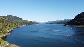
Green Peter Reservoir is a reservoir created by Green Peter Dam on the Middle Santiam River 11 miles (18 km) northeast of Sweet Home, Oregon, United States. The reservoir is approximately 10 miles (16 km) long and has a surface area of approximately 3,720 acres (1,510 ha) when full. The reservoir is used for hydropower, recreation, flood risk management, water quality, irrigation, and as a fish and wildlife habitat.

Big Cliff Dam is a concrete gravity dam on the North Santiam River in the western part of the U.S. state of Oregon. The dam spans the Linn County–Marion County border in the Oregon Cascades.

Fall Creek Lake is a reservoir in Lane County, in the U.S. state of Oregon. It is about 22 miles (35 km) southeast of Eugene on Fall Creek, immediately upstream from Unity Bridge, a covered bridge. The communities of Unity, at the bridge site, and Lowell, south of Unity, are near the lake. The unincorporated community of Jasper is further downstream, below the confluence of Fall Creek with the Middle Fork Willamette River.
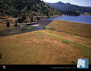
Cottage Grove Lake is a reservoir on the Coast Fork Willamette River in Lane County, Oregon, United States. The lake is about 3 miles (4.8 km) long.
