
Lake Panasoffkee is a census-designated place (CDP) in Sumter County, Florida, United States. The population was 3,551 at the 2010 census.

The St. Johns River is the longest river in the U.S. state of Florida and it is the most significant one for commercial and recreational use. At 310 miles (500 km) long, it flows north and winds through or borders twelve counties. The drop in elevation from headwaters to mouth is less than 30 feet (9
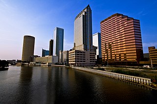
The Hillsborough River is a river located in the state of Florida in the United States. It arises in the Green Swamp near the juncture of Hillsborough, Pasco and Polk counties, and flows 60 miles (97 km) through Pasco and Hillsborough Counties to an outlet in the city of Tampa on Hillsborough Bay. It includes 4 nature trails extending for over 7 miles (11 km), making it popular among hikers. The name Hillsborough River first appeared on a British map in 1769. At the time, the Earl of Hillsborough was the British Secretary of State for the Colonies, and thus controlled the pensions of the surveyors working in the American colonies, which included East Florida.
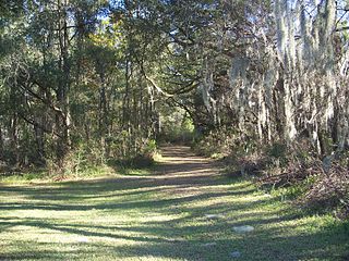
The Marjorie Harris Carr Cross Florida Greenway is a protected green belt corridor, more than one and a half miles (2.4 km) wide in places, that was the former route of the proposed Cross Florida Barge Canal. It is named for the leader of the opposition to the Cross Florida Barge Canal, Marjorie Harris Carr, and was originally a U.S. Army Corps of Engineers canal project to connect the Gulf of Mexico and the Atlantic Ocean across Florida for barge traffic. Two sections were built, but the project was ultimately cancelled because of local opposition related to environmental concerns, including protecting the state's water supply and conservation of the Ocklawaha River Valley ecosystem, as well as national opposition for the costs being perceived as "government waste" with "limited national value". The greenway is part of the system of Florida State Parks, including the Santos Trail System, and is managed by the Florida Department of Environmental Protection.

The 74-mile-long (119 km) Ocklawaha River flows north from central Florida until it joins the St. Johns River near Palatka. Its name is derived from ak-lowahe, Creek for "muddy".

The Florida Trail is one of eleven National Scenic Trails in the United States, created by the National Trails System Act of 1968. It runs 1,500 miles (2,400 km), from Big Cypress National Preserve to Fort Pickens at Gulf Islands National Seashore, Pensacola Beach. Also known as the Florida National Scenic Trail, the trail provides permanent non-motorized recreation for hiking and other compatible activities within an hour's drive of most Floridians.

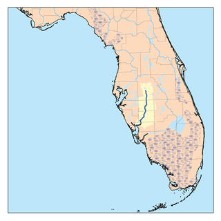
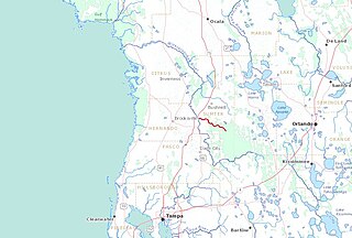
The Withlacoochee River or Crooked River is a river in central Florida, in the United States. It originates in the Green Swamp, east of Polk City, flowing west, then north, then northwest and finally west again before emptying into the Gulf of Mexico near Yankeetown. The river is 141 miles (227 km) long and has a drainage basin of 1,170 square miles (3,000 km2).
The Tampa Bypass Canal and Palm River are a 14-mile-long (23 km) flood bypass operated by the Southwest Florida Water Management District. The canal includes several concrete flood control structures and was constructed during the 1960s and 1970s. Its purpose is to redirect flood waters from large amounts of rainfall from the Hillsborough River to Tampa Bay to prevent floodwaters reaching homes and businesses. Despite its original purpose it is now used as a drinking water source for the City of Tampa. During construction of the canal the Floridan aquifer was accidentally breached.
The Southwest Florida Water Management District is one of five regional agencies directed by Florida state law to protect and preserve water resources. Established in 1961, the agency operates and maintains several large properties and flood protection projects, sometimes with other agencies. The District's responsibilities have expanded to include managing water supply and protecting water quality and the natural systems — rivers, lakes, wetlands, and associated uplands. The district's stated mission is to protect water resources, minimize flood risks, and ensure the public's water needs are met.

Colt Creek State Park is a Florida State Park in Central Florida, 16 miles (26 km) north of Lakeland off of State Road 471. This 5,067 acre park nestled within the Green Swamp Wilderness Area and named after one of the tributaries that flows through the property was opened to the public on January 20, 2007. Composed mainly of pine flatwoods, cypress domes and open pasture land, this piece of pristine wilderness is home to many animal species including the American bald eagle, Southern fox squirrel, gopher tortoise, white-tailed deer, wild turkey and bobcat.
The Black Hammock Wilderness Area is a 700-acre (2.8 km2) joint purchase between Seminole County, Florida and the St. Johns River Water Management District. It was acquired as part of a comprehensive effort to preserve significant habitat along the shores of Lake Jesup. This particular area also helps protect important recharge areas for the Geneva Bubble. Additionally, the wetland habitats of this property filter water on its way to Lake Jesup

Starkey Wilderness Preserve is a public recreation and nature conservation area located in Pasco County, Florida. The park includes a system of hiking, bicycling, and equestrian trails, cabins and primitive camping sites, and picnic areas. It is named after Jay B. Starkey, a cattle rancher who bought the property in 1937 and later donated hundreds of acres. The Preserve consists of three tracts: the Jay B. Starkey Wilderness Park, managed by Pasco County, and Serenova Tract and the Anclote River Ranch Tract, managed by Southwest Florida Water Management District. The area includes sections of pine flatwoods, cypress domes, freshwater marshes, stream and lake swamps, sandhill and scrub over a combined 8,500-acre (34 km2) "wetland ecosystem spread throughout approximately 18,000 acres of conservation lands". The park is located in Western Pasco County east of New Port Richey. The park includes the Starkey Trail, an approximately 6.7 mile paved multi-use trail that links up with the Suncoast Trail at its eastern terminus. There are also unimproved trails in the park. An 8-mile mountain bike trail was approved and being developed as of 2013.
Brooker Creek Headwaters Nature Preserve is located in northwest Hillsborough County, Florida and is managed by the Southwest Florida Water Management District. The 1,111-acre (4.50 km2) area is located at 18102 Ramblewood Road in Lutz, Florida and offers hiking opportunities. It protects wetlands and headwaters of the Brooker Creek watershed.
Hálpata Tastanaki Preserve is located in Marion County, Florida and is part of the Southwest Florida Water Management District. It is 8,146 acres (32.97 km2) and located at 15430 SW CR 484 in Dunnellon. Various sports and recreation opportunities are offered by the park including hiking, fishing, biking, horseback riding and picnicking.
Green Swamp Wilderness Preserve is a 110,000 acre preserve in the four-corner area of Lake County, Pasco County, Polk County and Sumter County, east of Dade City, Florida. It includes a 36-mile section of the Withlacoochee River and offers hiking trails. It is managed by the Southwest Florida Water Management District. It includes various habitats and is home to a wide array of wildlife. The preserve is divided into five areas: 5,067 acre Colt Creek State Park, the 51,149 acre East Tract; the 11,052 acre Hampton Tract; the 4,446 acre Little Withlacoochee Tract; and the 37,350 acre West Tract.
Kissingen Spring was a natural spring formerly flowing in Polk County, Southwest Florida. It was also a venue for recreation until it dried up in 1950. Hundreds of wells drilled into the Floridan Aquifer may have caused the demise of the springs. Its site is located near the northern end of Peace River, approximately 3/4 mile east of U.S. Highway 17 and 4 miles south of Florida SR 60 / south of Bartow.
Deep Creek Conservation Area is an area of protected lands near Hastings, Florida in St. Johns County and Putnam County that is managed by the St. Johns River Water Management District.
Greater Tampa Bay Area Council serves Scouts in West-Central Florida with the council headquarters in Tampa, Florida. Youth are served in the following nine counties: Citrus, Hardee, Hernando, Highlands, Hillsborough, Pasco, Pinellas, Polk and Sumter. Greater Tampa Bay Area Council was formed on May 1, 2016, by the merger of Gulf Ridge Council with West Central Florida Council.
The Little Withlacoochee River is a 16-mile long river with its headwaters starting in the Richloam Wildlife Management Area in Sumter County, Florida. The Little Withlacoochee River ends near River Junction Campground just east of Silver Lake in the Croom Wildlife Management Area. It makes up a portion of the Hernando-Sumter County border. Its drainage basin covers 145 mi2 (376 km2) of Hernando County and Sumter County.