
The Mississippi River is the primary river, and second-longest river, of the largest drainage basin in the United States. From its traditional source of Lake Itasca in northern Minnesota, it flows generally south for 2,340 miles (3,766 km) to the Mississippi River Delta in the Gulf of Mexico. With its many tributaries, the Mississippi's watershed drains all or parts of 32 U.S. states and two Canadian provinces between the Rocky and Appalachian mountains. The main stem is entirely within the United States; the total drainage basin is 1,151,000 sq mi (2,980,000 km2), of which only about one percent is in Canada. The Mississippi ranks as the thirteenth-largest river by discharge in the world. The river either borders or passes through the states of Minnesota, Wisconsin, Iowa, Illinois, Missouri, Kentucky, Tennessee, Arkansas, Mississippi, and Louisiana.

Bull Shoals Lake is an artificial lake or reservoir in the Ozark Mountains of northern Arkansas and southern Missouri, United States. It has hundreds of miles of lake arms and coves, and common activities include boating, water sports, swimming, and fishing. Nineteen developed parks around the shoreline provide campgrounds, boat launches, swim areas, and marinas.

Beaver Lake is a man-made reservoir in the Ozark Mountains of Northwest Arkansas and is formed by a dam across the White River. Beaver Lake has some 487 miles (784 km) of shoreline. With towering limestone bluffs, natural caves, and a wide variety of trees and flowering shrubs, it is a popular tourist destination. Beaver Lake is the source of drinking water in Northwest Arkansas, which is managed, treated and sold by Beaver Water District, serving more than 450,000 customers. One out of 7 people in Arkansas get their drinking water from Beaver Lake.

Lake Strom Thurmond, officially designated J. Strom Thurmond Reservoir at the federal level, and Clarks Hill Lake by the state of Georgia, is a man-made reservoir at the border between the U.S. states of Georgia and South Carolina in the Savannah River Basin.

The Sepulveda Dam is a dry dam constructed by the U.S. Army Corps of Engineers to withhold winter flood waters along the Los Angeles River. Completed in 1941, at a cost of $6,650,561, it is located south of center in the San Fernando Valley, approximately eight miles (13 km) east of the river's source in the western end of the Valley, in Los Angeles, California.

Fort Randall Dam is a 2.03-mile-long (3 km) earthen dam which spans the Missouri River and impounds Lake Francis Case, the 11th-largest reservoir in the U.S. The dam joins Gregory and Charles Mix counties, South Dakota a distance of 880 river miles (1,416 km) upstream of St. Louis, Missouri, where the river joins the Mississippi River. The dam and hydroelectric power plant were constructed by and are currently operated by the U.S. Army Corps of Engineers.

Tenkiller Ferry Lake, or more simply, Lake Tenkiller, is a reservoir in eastern Oklahoma formed by the damming of the Illinois River. The earth-fill dam was constructed between 1947 and 1952 by the United States Army Corps of Engineers for purposes of flood control, hydroelectric power generation, water supply and recreation. It went into full operation in 1953. The lake and dam were named for the Tenkiller family, prominent Cherokees who owned the land and ferry that were bought for the project. This is the 6th largest lake in Oklahoma, based on water capacity.

Keystone Lake is a reservoir in northeastern Oklahoma on the Arkansas and Cimarron rivers. It is located upstream about 23 miles (37 km) from Tulsa. It was created in 1968 when the Keystone Dam was completed. The primary purposes are: flood control, hydroelectric power generation, wildlife management and recreation.

Table Rock Lake is an artificial lake or reservoir in the Ozarks of southwestern Missouri and northwestern Arkansas in the United States. Designed, built and operated by the U.S. Army Corps of Engineers, the lake is impounded by Table Rock Dam, which was constructed from 1954 to 1958 on the White River.

Jennings Randolph Lake is a reservoir of 952 acres (3.85 km2) located on the North Branch Potomac River in Garrett County, Maryland and Mineral County, West Virginia. It is approximately 8 miles (13 km) upstream of Bloomington, Maryland, and approximately 5 miles (8.0 km) north of Elk Garden, West Virginia.
Saylorville Lake is a reservoir on the Des Moines River in Iowa, United States. It is located 11 miles (18 km) upstream from the city of Des Moines, and 214 miles (344 km) from the mouth of the Des Moines River at the Mississippi River. It was constructed as part of a flood control system for the Des Moines River as well as to aid in controlling flood crests on the Mississippi, of which the Des Moines is a tributary. The lake and dam is owned and operated by the U.S. Army Corps of Engineers, Rock Island District.

Gavins Point Dam is a 1.9-mile-long (3 km) embankment rolled-earth and chalk-fill dam which spans the Missouri River and impounds Lewis and Clark Lake. The dam joins Cedar County, Nebraska with Yankton County, South Dakota a distance of 811.1 river miles (1,305 km) upstream of St. Louis, Missouri, where the river joins the Mississippi River. The dam and hydroelectric power plant were constructed as the Gavins Point Project from 1952 to 1957 by the United States Army Corps of Engineers as part of the Pick-Sloan Plan. The dam is located approximately 4 miles (6.4 km) west or upstream of Yankton, South Dakota.
Sardis Lake is a 98,520-acre (398.7 km2) reservoir on the Tallahatchie River in Lafayette, Panola, and Marshall counties, Mississippi. Sardis Lake is impounded by Sardis Dam, located nine miles (14 km) southeast of the town of Sardis. It is approximately an hour drive from Memphis, Tennessee. The dam is 15,300 feet (4,700 m) long, has an average height of 97 feet (30 m), and a maximum height of 117 feet (36 m).

Arkabutla Lake is a reservoir on the Coldwater River in the U.S. state of Mississippi. It was created following the construction of the Arkabutla Dam in 1940 on the Coldwater River.

Perry Lake is a US Army Corps of Engineers operated reservoir in northeast Kansas. Its primary purposes are flood control, water reserve for nearby areas and regional recreation. The lake is approximately 11,150 acres (45 km2) in size, with over 160 miles (260 km) of shoreline. Perry Lake's full multi-purpose pool elevation is 891.5 feet (271.7 m) above sea level. Perry Lake is located about 40 miles (64 km) west of Kansas City, just northwest of Lawrence, Kansas. Its close proximity to Kansas City, Lawrence, and the state capitol, Topeka, make it a very popular destination, with the nickname "Paradise on the Plains".

Mansfield Hollow Lake is a reservoir resting on the border of Windham County and Tolland County, Connecticut. The reservoir provides drinking water for Willimantic and helps control flooding in the 159-square-mile Thames River watershed. It was created by the Mansfield Hollow Dam and is entirely contained within Mansfield Hollow State Park and the Mansfield Hollow Wildlife Area. Designed and constructed by the United States Army Corps of Engineers, the dam substantially reduces flooding along the Quinebaug, Shetucket, and Thames rivers. Construction of the project began in 1949 with completion in 1952 at a cost of US$6.5 million. The Mansfield Hollow reservoir is located within the Shetucket River Watershed and is part of the Thames River Basin. Access to the site is available from US Route 6 and State Route 195. The damsite, covering an area of 25 acres (10 ha), was listed on the National Register of Historic Places in 2003.

Hugo Lake is manmade lake located 7 miles (11 km) east of Hugo, in Choctaw County, Oklahoma, United States. It is formed by Hugo Lake Dam on the Kiamichi River 18 miles (29 km) upstream from the Red River. The dam is visible from U.S. Route 70, which crosses its spillway just west of Sawyer. Lake Hugo features approximately 110 miles (180 km) of shoreline and covers over 13,250 acres (53.6 km2), or 20 square miles (52 km2). Its normal pool elevation is 404.5 feet (123.3 m) above sea level and its normal storage capacity is 157,600 acre-feet (194,400,000 m3). At flood stage its elevation is at 437.5 feet (133.4 m) above sea level and it is capable of storing 966,700 acre-feet (1.1924×10⁹ m3) of flood waters. The lake's primary functions are to provide flood control, water storage, and recreational opportunities.

The Conant Brook Dam is located on Conant Brook in Monson, Massachusetts, about 7.4 miles (11.9 km) upstream from the confluence of Conant Brook and the Quaboag River. It is approximately 15 miles (24 km) east of Springfield, Massachusetts.

John Redmond Reservoir is a reservoir on the Neosho River in eastern Kansas. Built and managed by the U.S. Army Corps of Engineers, it is used for flood control, recreation, water supply, and wildlife management. It borders the Flint Hills National Wildlife Refuge to the northwest.
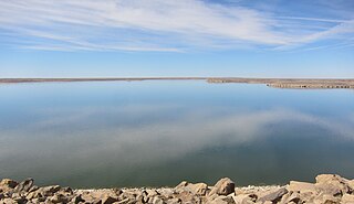
John Martin Reservoir is a reservoir on the Arkansas River in Bent County in southeastern Colorado. Built and managed by the U.S. Army Corps of Engineers, it is used for flood control, irrigation, and recreation. John Martin Reservoir State Park lies on its shore.


