Lower Saxony is a German state in northwestern Germany. It is the second-largest state by land area, with 47,614 km2 (18,384 sq mi), and fourth-largest in population among the 16 Länder of the Federal Republic of Germany. In rural areas, Northern Low Saxon and Saterland Frisian are still spoken, though by declining numbers of people.

The Meuse or Maas is a major European river, rising in France and flowing through Belgium and the Netherlands before draining into the North Sea from the Rhine–Meuse–Scheldt delta. It has a total length of 925 km.

The Rhine is one of the major European rivers. The river begins in the Swiss canton of Graubünden in the southeastern Swiss Alps. It forms the Swiss-Liechtenstein border and partly the Swiss-Austrian and Swiss-German borders. After that the Rhine defines much of the Franco-German border, after which it flows in a mostly northerly direction through the German Rhineland. Finally in Germany, the Rhine turns into a predominantly westerly direction and flows into the Netherlands where it eventually empties into the North Sea. It drains an area of 9,973 km2.

Drenthe is a province of the Netherlands located in the northeastern part of the country. It is bordered by Overijssel to the south, Friesland to the west, Groningen to the north, and the German state of Lower Saxony to the east. As of January 2023, Drenthe had a population of about 502,000, and a total area of 2,680 km2 (1,030 sq mi).

The Ems is a river in northwestern Germany. It runs through the states of North Rhine-Westphalia and Lower Saxony, and discharges into the Dollart Bay which is part of the Wadden Sea. Its total length is 362.4 kilometres (225.2 mi). The state border between the Lower Saxon area of East Friesland (Germany) and the province of Groningen (Netherlands), whose exact course was the subject of a border dispute between Germany and the Netherlands, runs through the Ems estuary.

Weener is a town in the district of Leer, in Lower Saxony, Germany. It is situated near the border with the Netherlands, on the river Ems. The towns population is at 15,654, making it the largest town of the region Rheiderland. It has a railway and autobahn connection to Groningen, Netherlands, Emden and Bremen.

The Wadden Sea National Parks in Denmark, Germany and the Netherlands are located along the German Bight of the North Sea. In Germany and Denmark they also mark the area of the UNESCO World Heritage Site of the Wadden Sea. Divided from each other by administrative borders, they form a single ecological entity. The purpose of the national parks is the protection of the Wadden Sea ecoregion.

The Fulda is a river of Hesse and Lower Saxony, Germany. It is one of two headstreams of the Weser. The Fulda is 220.4 kilometres (137.0 mi) long.

The Amer is a river in the Dutch province of North Brabant. It is a continuation of the Bergse Maas river from the river Donge near Raamsdonksveer to the point where it joins the river Nieuwe Merwede to form the Hollands Diep estuary, and has a total length of approximately 20 kilometres (12 mi). The Amer is a major navigation route. It forms the south boundary of the Biesbosch National Park.

Wümme is a river in northern Germany, in the states Lower Saxony and Bremen, marking the border between the two states for part of its course. It is the main headstream of the Lesum.

The Vechte or Vecht, often called Overijsselse Vecht in the Netherlands to avoid confusion with its Utrecht counterpart, is a river in Germany and the Netherlands. Its total length is 182 km (113 mi), of which 107 km (66 mi) is in Germany.
The geology of the Netherlands describes the geological sequence of the Netherlands. Large parts of the Netherlands today are below sea level and have in the past been covered by the sea or flooded at regular intervals. The modern Netherlands formed as a result of the interplay of the four main rivers and the influence of the North Sea and glaciers during ice-ages. The Netherlands is mostly composed of deltaic, coastal and eolian derived sediments during the Pleistocene glacial and interglacial periods.

Emlichheim is a municipality in the district of Grafschaft Bentheim in Lower Saxony, Germany, roughly 20 km south of Emmen, and 25 km northwest of Nordhorn.

Rhede is a municipality in the Emsland district, Lower Saxony, Germany. It is situated on the river Ems, near the border with the Netherlands, approx. 10 km west of Papenburg, and 20 km southeast of Winschoten.

The Dinkel is a river in Germany and the Netherlands, left tributary of the Vecht. Its total length is 89 km (55 mi), of which 47 km (29 mi) in Germany. The Dinkel originates in North Rhine-Westphalia, Germany, between Ahaus and Coesfeld. It flows north to Gronau, crosses the border with the Netherlands (Overijssel), flows through Losser, Denekamp, and recrosses the border to Germany. The Dinkel joins the Vechte in Neuenhaus.

Dersum is a municipality in the Emsland district, in Lower Saxony, Germany. It lies between the River Ems in the east and the border with the Netherlands in the west. Haren is about 24 kilometers to the south and Papenburg about 17 kilometres to the north east.

Lühe is a river in northern Germany in the district of Stade in Lower Saxony, Germany.
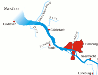
The Unterelbe or, in English usually the Lower Elbe, refers to the lower reaches of the river Elbe in Germany influenced by the tides.