Twist, Germany

Last updated
Twist
Flagge Twist.svg
DEU Twist COA.svg
Location of Twist within Emsland district
Twist in EL.svgDohrenGeesteHarenHeedeLahnLangenLeheLengerichLingenRhedeStavernTwist
Germany adm location map.svg
Red pog.svg
Twist
Lower Saxony location map.svg
Red pog.svg
Twist
Coordinates: 52°37′N07°02′E / 52.617°N 7.033°E / 52.617; 7.033 Coordinates: 52°37′N07°02′E / 52.617°N 7.033°E / 52.617; 7.033
Country Germany
State Lower Saxony
District Emsland
Government
   Mayor (201924) Petra Lübbers [1] (CDU)
Area
  Total105.61 km2 (40.78 sq mi)
Elevation
16 m (52 ft)
Population
 (2021-12-31) [2]
  Total9,554
  Density90/km2 (230/sq mi)
Time zone UTC+01:00 (CET)
  Summer (DST) UTC+02:00 (CEST)
Postal codes
49767
Dialling codes 0 59 36
Vehicle registration EL
Website www.twist-emsland.de

Twist is a municipality in the Emsland district, in Lower Saxony, Germany. It is situated directly on the Dutch border.

Contents

Situation of the local parts in the municipality of Twist:

Gemeinde Twist.png
  1. Adorf
  2. Hebelermeer
  3. Hesepertwist (Twist-Siedlung)
  4. Neuringe
  5. Rühlerfeld and Rühlermoor
  6. Rühlertwist (Twist-Bült)
  7. Schöninghsdorf and Provinzialmoor

More than half of the population lives in the center of the municipality (i.e. Twist-Siedlung and Bült). The other half is spread over the other villages, of which Schöningsdorf (population about 1100) and Rühlerfeld (900) are the largest. [3] The other villages are smaller (Adorf about 500, Hebelermeer 400, Neuringe 300 inhabitants).

History

The settlement in the area of today's municipality Twist began quite late around the year 1784. The prince-bishop of Münster Max Franz satisfied the wishes of some "Heuerleute", a kind of farmer, from the nearby village of Hesepe to settle down in the bog "Twist". This was the starting point of the settlement in Twist; to be more precise it starts at the street of houses which is nowadays called "Alt-Hesepertwist". The ground was at that time quite infertile because of its composition and did just allow a meager livelihood and so the people did not live in any comfort. The construction of the canal "Nord-Süd-Kanal" about 100 years later brought significant improvements in the quality of life of the people, because the canal allowed a systematic drainage and removal of the peat.

In the 1950s the economic revival finally arrived on the one hand by finding larger oil deposits and on the other hand by commissioning of the production site of the Dutch plastics company Wavin. These two factors were over some decades the driving forces for the economical rise of Twist.

In 1986 Twist celebrated its 200th anniversary. The anniversary festivities ended with a pageant which had respect to the history and current circumstances in Twist. For instance one of the numerous parade floats showed a detailed replica of the church St. Georg (biggest church in Twist).

In the 1990s the two main columns of Twist's economy, oil production and the plastic production declined more and more; and economic hard times meant many people lost their jobs. With the finishing of the autobahn 31 at the end of the 1990s this negative development was stopped by siting new companies especially in the industrial area close to the autobahn.

In August/September 2011 Twist celebrated its 225th anniversary. The 10-day-long festival started with a "Twist-Schau" (Twist Show). This show was performed like a play in Low German language and telling the history of Twist in a humorous way, with its good old times, but also the very hard living conditions of the first settlers, the loss of loved family members during WWII and the upcoming prosperity caused by the fast economic growth of the last 60 years that offers people of about 30 different nations a new home in Twist.

One of the following days of the festival was themed as "Tag der Vereine" (Day of the Associations) presenting all sporting, cultural and welfare associations in Twist. It showed the wide range of activities for spare time and hobbies. Another motto of one of the festival days was "Twist macht Musik" (Twist plays music) where all choirs in Twist performed their songs and left the audience very impressed.

Part of the festival were also concerts by Queen and Pink Floyd cover bands. The festival finally ended by presenting a pageant related to historical and present developments in Twist.

Origin of the name

The origin of the name of the municipality Twist has nothing to do with the dance style of the same title. Due to a long disagreement with the Dutch Kingdom about the way the border between both countries should take it was common language use to speak about "Twistrich" or "Twist Gebiet" (Twist area). In Low German "Twistrich" or "Twist Gebiet" has a meaning similar to "disputed border". This language was the official language at that time and is still partly in usage.

The name is commonly mispronounced as locals pronounce it "Tweest". [4]

New research results from Jürgen Udolph, a known scientist in the fields of onomastics, shows that the name Twist probably has its origin in the words "twistel" in the meaning of "Zwiesel" or "Zweiung", that means something is at a bifurcation. In this meaning also words like "zwieträchtig", "twisten" and "in Zweispalt, Streit sein" (in English: discrepancy, dispute) belong to the explanation of the origin of the name Twist. The conclusion of Udolph is, that the name of Twist means something like "separated settlement, a place located at a (stream) bifurcation".

Landmarks

Church St. Vinzenz von Paul zu Hebelermeer

The parish church in the district Heblermeer houses two rococo busts of Ignatius of Loyola and Francisco de Xavier created by the sculptor Johann Heinrich König (1705–1784).

Church St. Franziskus

In December 1928 the construction work on the church started. The architect Theo Burlage designed the church in the style of expressionism. One year after starting construction the first service in the church was celebrated on December 8, 1929. In August 1930 bishop Berning did consecrated the church. The altar crucifix was designed by Wolfdietrich Stein. With a height of 5 meters it fills the complete height and width of the sanctuary.

The church spire has clock faces on three of its sides. Contrary to ordinary clock faces, these ones do not show numbers. The top figure is an Iron Cross with the date of 1914 and 1918 (duration of World War I). The other 33 figures on the clock faces are name tags with the names of the soldiers killed in action from the villages Schönighsdorf and Provinzialmoor.

Protestant church in Neuringe

An exceptional feature is the Protestant church in the district of Neuringe, because this church boasts one of the oldest and most valuable organs (constructed in 1719) of the Protestant national church. The church itself was constructed in 1904. As in many villages at that time, there was no money for both construction of the church and the buying of inventory. Therefore, a used organ was bought. Sometimes, as in this case, the used ones have a higher value nowadays than organs that were built in the 1900s.

Center of Twist

In the center of the municipality of Twist numerous retailers are located, such as grocery stores, a travel agency, a bank and so on. Also the city hall and the police station is situated in the center of Twist. A special attraction in the center is the museum for crude oil and natural gas (Erdöl-Erdgas-Museum Twist) and also the "Heimathaus Twist". The Heimathaus Twist is known for legendary blues, folk, and jazz concerts.

Landscape

In 2006 the German counties Emsland and Grafschaft Bentheim founded together with the Dutch province Drenthe the "Internationaler Naturpark Moor" (International Nature Park Bog) (wetlands). This park stretches across big parts of the municipality Twist. The park has a unique biota and is the wintering grounds for numerous migratory birds every year.

Up to the settlement and cultivation in the 19th century, the area was one of the biggest peat moss areas in Europe with a size of more than 1,200 km². In recent years several projects have started to block ditches and generate a water logging of the area for renaturation. A very successful example for the renaturation in the nature park is the Dutch part of the park, where already in the 1960s first projects started and led to a fully restored peat moss area where very rare plants and animals found a new home.

Recreational activity and culture

Culture

The "Heimathaus Twist" is a reconstructed old farm house located in the center of Twist. It is known for blues and folk concerts which also take place several times a year. However, several events especially for children are also organized by the team of the "Heimathaus Twist". Directly beside the "Heimathaus Twist" the museum for crude oil and natural gas is located. It shows several exhibits on this topic and the historical development of the extraction of crude oil and natural gas. The crude oil and natural gas industry has a long history in the area of Twist for this reason it was sometimes also called the German Texas.

Recreational activity

In every district of Twist there are several sport clubs where soccer is the dominant sport, but basketball, table-tennis, competitive dance, horseback riding, swimming, tennis, handball and gymnastics are also offered.

Family policy

In May 2007 the town council decided measures to support families with children. Hence families with two or three children get a special concession on a building land for a one-family house. Families with four children get a building site for free. For this rule limited in time (till 31 December 2009) children count who are younger than 15 years and born the first 10 years after purchase.

Economy and Infrastructure

Traffic

By car

Twist has a direct connection to the Autobahn 31 which acts as north-south route between the North Sea and the Ruhr. Twist is also connected to Europastraße 233 which is constructed on German side like an Autobahn to the connection point with Autobahn 31 and on Dutch side it already has the status as Autobahn A 37. This Europastraße (E 233) connects the metropolis Rotterdam, Amsterdam with Hamburg and finally Scandinavia. On the German side it's intended over the next years to follow the Dutch side and to convert the road over the whole distance into an Autobahn.

Air traffic

The closest international airport is Münster Osnabrück Airport in the German city Greven. The airport is about 90 km away from Twist and easy to reach by using the Autobahn 31 and later changing to Autobahn 30.

Düsseldorf is the closest international hub for intercontinental flights. The distance to the airport is approximately 170 km (1,5 hours by car) and for the whole travel distance it is possible to use the Autobahn. Düsseldorf Airport can be reached directly on the Autobahn 31 and later, after changing to Autobahn 44, leaving at the exit airport (Ausfahrt Flughafen).

Amsterdam Airport Schiphol is another airport close by. The airport is about 200 km away and easy to reach on the Dutch high-speed road network. The Dutch "Autobahn" A 37 starts in Twist and for the whole distance to the airport an Autobahn can be used.

Economy

Till the middle of the nineteen-nineties the crude oil, natural gas, and peat industry dominated the economy in Twist. Especially in these industries many employees lost their job at that time. Since then many small and medium size business companies have settled down in the area of Twist especially in the industrial park at the autobahn. The biggest employer in Twist is the Dutch company Wavin. This company is European market leader for plastic pipe systems.

Tourism

In recent years tourism has also become an important factor, where the focus of tourism is on the district of Neuringe. In addition to several holiday flats there is also a campground with a public lake for bathing and a farm for horseback riding. Especially this farm theme park enjoys great popularity among the younger guests. Furthermore, within the area of this farm is an indoor children's playground which is especially suitable for children up to the age of 12.

Education

In Twist there are 5 grade schools and one junior high. After a bigger replacement and newly constructed building in 2007, this junior high acts nowadays as full-time school. In 2009 the grade schools were also transformed into all day schools. By carrying out modernisation at the schools it is guaranteed nowadays that the students get a warm meal and are supervised throughout the day.

Related Research Articles

<span class="mw-page-title-main">Lower Saxony</span> State in Germany

Lower Saxony is a German state in northwestern Germany. It is the second-largest state by land area, with 47,614 km2 (18,384 sq mi), and fourth-largest in population among the 16 Länder federated as the Federal Republic of Germany. In rural areas, Northern Low Saxon and Saterland Frisian are still spoken, albeit in declining numbers.

<span class="mw-page-title-main">Oldenburg (city)</span> City in Lower Saxony, Germany

Oldenburg (German pronunciation: [ˈɔldn̩bʊʁk](listen)) is an independent city in the state of Lower Saxony, Germany. The city is officially named Oldenburg (Oldb) (Oldenburg in Oldenburg) to distinguish from Oldenburg in Holstein.

<span class="mw-page-title-main">Groningen (province)</span> Northeasternmost province of the Netherlands

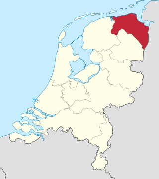
Groningen is the northeasternmost province of the Netherlands. It borders on Friesland to the west, Drenthe to the south, the German state of Lower Saxony to the east, and the Wadden Sea to the north. As of February 2020, Groningen had a population of 586,309 and a total area of 2,960 km2 (1,140 sq mi).

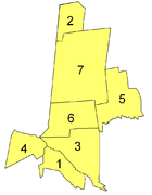
Leer is a district (Landkreis) in Lower Saxony, Germany. It is bounded by the city of Emden, the districts of Aurich, Wittmund, Friesland, Ammerland, Cloppenburg and Emsland, and by the Netherlands.

Landkreis Emsland is a district in Lower Saxony, Germany named after the river Ems. It is bounded by the districts of Leer, Cloppenburg and Osnabrück, the state of North Rhine-Westphalia, the district of Bentheim in Lower Saxony, and the Netherlands.

<span class="mw-page-title-main">Salzgitter</span> Place in Lower Saxony, Germany

Salzgitter is an independent city in southeast Lower Saxony, Germany, located between Hildesheim and Braunschweig. Together with Wolfsburg and Braunschweig, Salzgitter is one of the seven Oberzentren of Lower Saxony. With 101,079 inhabitants and 223.92 square kilometres (86.46 sq mi), its area is the largest in Lower Saxony and one of the largest in Germany. Salzgitter originated as a conglomeration of several small towns and villages, and is today made up of 31 boroughs, which are relatively compact conurbations with wide stretches of open country between them. The main shopping street of the young city is in the borough of Lebenstedt, and the central business district is in the borough of Salzgitter-Bad. The city is connected to the Mittellandkanal and the Elbe Lateral Canal by a distributary. The nearest metropolises are Braunschweig, about 23 kilometres to the northeast, and Hanover, about 51 km to the northwest. The population of the City of Salzgitter has exceeded 100,000 inhabitants since its foundation in 1942, when it was still called Watenstedt-Salzgitter. Beside Wolfsburg, Leverkusen and Eisenhüttenstadt, Salzgitter is one of the few cities in Germany founded during the 20th century.

<span class="mw-page-title-main">Leer, Lower Saxony</span> Town in Lower Saxony, Germany

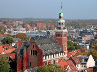
Leer is a town in the district of Leer, in the northwestern part of Lower Saxony, Germany. It is situated on the river Leda, a tributary of the river Ems, near the border with the Netherlands. With 34,958 inhabitants (2021), it is the third-largest city in East Frisia after Emden and Aurich.

<span class="mw-page-title-main">Uslar</span> Town in Lower Saxony, Germany

Uslar is a town and a municipality in southern Lower Saxony, Germany, in the south-western part of the district of Northeim, and in the south of the hills of Solling forest which are part of the Weser Uplands.

<span class="mw-page-title-main">Melle, Germany</span> Town in Lower Saxony, Germany

Melle is a city in the district of Osnabrück, Lower Saxony, Germany. The city corresponds to what used to be the district of Melle until regional territorial reform in 1972. Since then Melle is the third largest city in Lower Saxony in terms of surface area.

<span class="mw-page-title-main">Börger</span> Municipality in Lower Saxony, Germany

Börger is a village and a municipality in the district Emsland in Lower Saxony, Germany. Börger is part of the administrative unit of Sögel.

<span class="mw-page-title-main">Meppen</span> Town in Lower Saxony, Germany

Meppen is a town in and the seat of the Emsland district of Lower Saxony, Germany, at the confluence of the Ems, Hase, and Nordradde rivers and the Dortmund–Ems Canal (DEK). The name stems from the word Mappe, meaning "delta".

<span class="mw-page-title-main">Bösel</span> Municipality in Lower Saxony, Germany

Bösel is a municipality in the district of Cloppenburg, in Lower Saxony, Germany.

<span class="mw-page-title-main">Emlichheim</span> Municipality in Lower Saxony, Germany

Emlichheim is a municipality in the district of Grafschaft Bentheim in Lower Saxony, Germany, roughly 20 km south of Emmen, and 25 km northwest of Nordhorn.

<span class="mw-page-title-main">Bernau am Chiemsee</span> Municipality in Bavaria, Germany

Bernau am Chiemsee is a municipality in the district of Rosenheim in Germany on the Lake Chiemsee, and a Luftkurort.

<span class="mw-page-title-main">Lähden</span> Municipality in Lower Saxony, Germany

Lähden is a municipality in the Emsland district, in Lower Saxony, Germany.

<span class="mw-page-title-main">Heimathaus Twist</span>

The Heimathaus Twist is a cross-community cultural center in the municipality of Twist, Germany well known and for blues and folk music concerts nationwide.

<span class="mw-page-title-main">Erdöl-Erdgas-Museum Twist</span>

The Erdöl-Erdgas-Museum Twist in Twist, Germany is a museum for crude oil and natural gas and shows technical equipment for mineral exploration of these natural energy resources and gives information about their geological origin.

<span class="mw-page-title-main">Internationaler Naturpark Bourtanger Moor-Bargerveen</span> Nature reserve in northern Netherlands and Germany

The Internationaler Naturpark Bourtanger Moor-Bargerveen is a nature reserve in the west of the German state Lower Saxony as well as in the North-East of the Netherlands. Mostly this nature reserve is spread out over the German counties Emsland, Grafschaft Bentheim and the Dutch province Drenthe. The landscape within the nature park is characterised by big peat areas, heather, small lakes and a very low human population density. The Bourtanger Moor-Bargerveen International Nature Park was founded on June 1, 2006.

<span class="mw-page-title-main">Bourtange moor</span> Bog area in northern Germany and Netherlands

The Bourtanger Moor was a bog in eastern parts in the Dutch provinces of Drenthe and Groningen and the bordering German districts of Bentheim and Emsland. A remaining stretch on the border between Drenthe and the districts Emsland and Betheim is now a nature reserve, the Internationaler Naturpark Bourtanger Moor-Bargerveen.

<span class="mw-page-title-main">Pekel A</span> River in Groningen

Pekel A (also Pekel Aa; Dutch pronunciation: [ˈpeːkəl aː]) is a river in the Province of Groningen in the Netherlands. The villages of Oude Pekela and Nieuwe Pekela have been named after the river. The name translates to Brine (Pekel) River (A), and used to flow from the Dollart into a large raised bog. The Dollart was poldered from the 15th century until 1924, and the river now has its source at the confluence with the Westerwoldsche Aa at De Bult. The river was canalised and extended. The part from Oude Pekela to Stadskanaal was renamed Pekelderdiep. From 1599 until 1810, the area through which the river flowed, was a peat colony. In the 20th century, the Pekel A was a heavily polluted river, but it has been cleaned up since the 1970s.

References

  1. "Verzeichnis der direkt gewählten Bürgermeister/-innen und Landräte/Landrätinnen". Landesamt für Statistik Niedersachsen. April 2021.
  2. "LSN-Online Regionaldatenbank, Tabelle A100001G: Fortschreibung des Bevölkerungsstandes, Stand 31. Dezember 2021" (in German). Landesamt für Statistik Niedersachsen.
  3. https://www.citypopulation.de/de/germany/niedersachsen/emsland/03454054__twist/
  4. Ems Vechte Welle Archived 2011-07-19 at the Wayback Machine , published July 26, 2007