Internationaler Naturpark Bourtanger Moor-Bargerveen

Last updated
Internationaler Naturpark Bourtanger Moor-Bargerveen
Bourtanger Moor-Bargerveen International Nature Park
Karte Naturpark Bourtanger Moor-Bargerveen.png
Location of Bourtanger Moor-Bargerveen International Nature Park.
Location Lower Saxony, Germany
Drenthe, Netherlands
Nearest city Twist, Germany
Coordinates 52°39′22″N7°05′24″E / 52.656°N 7.09°E / 52.656; 7.09 [1] Coordinates: 52°39′22″N7°05′24″E / 52.656°N 7.09°E / 52.656; 7.09 [2]
Established2006

The Internationaler Naturpark Bourtanger Moor-Bargerveen (engl. Bourtanger Moor-Bargerveen International Nature Park) is a nature reserve in the west of the German state Lower Saxony as well as in the North-East of the Netherlands. Mostly this nature reserve is spread out over the German counties Emsland, Grafschaft Bentheim and the Dutch province Drenthe. The landscape within the nature park is characterised by big peat areas, heather, small lakes and a very low human population density. The Bourtanger Moor-Bargerveen International Nature Park was founded on June 1, 2006.

Nature reserve Protected area for flora, fauna or features of geological interest

A nature reserve is a protected area of importance for flora, fauna or features of geological or other special interest, which is reserved and managed for conservation and to provide special opportunities for study or research. Nature reserves may be designated by government institutions in some countries, or by private landowners, such as charities and research institutions, regardless of nationality. Nature reserves fall into different IUCN categories depending on the level of protection afforded by local laws. Normally it is more strictly protected than a nature park.

Germany Federal parliamentary republic in central-western Europe

Germany, officially the Federal Republic of Germany, is a country in Central and Western Europe, lying between the Baltic and North Seas to the north and the Alps, Lake Constance and the High Rhine to the south. It borders Denmark to the north, Poland and the Czech Republic to the east, Austria and Switzerland to the south, France to the southwest, and Luxembourg, Belgium and the Netherlands to the west.

Lower Saxony State in Germany

Lower Saxony is a German state (Land) situated in northwestern Germany. It is the second-largest state by land area, with 47,624 km2 (18,388 sq mi), and fourth-largest in population among the 16 Länder federated as the Federal Republic of Germany. In rural areas, Northern Low Saxon and Saterland Frisian are still spoken, but the number of speakers is declining.

Contents

Bourtanger Moor

Bourtanger Moor, the German part of the reserve, has a size of around 140 km2 (54 sq mi). Originally Bourtanger Moor had a size of 3,000 km2 (1,200 sq mi) which shows that nowadays the remaining part covers just a small area of its former dimension.

The nature reserve is the home of several special plants like common cottongrass and drosera and endangered animals like the viviparous lizard, grass snake, short-eared owl and European nightjar can be found in this reserve.

<i>Drosera</i> genus of plants

Drosera, commonly known as the sundews, is one of the largest genera of carnivorous plants, with at least 194 species. These members of the family Droseraceae lure, capture, and digest insects using stalked mucilaginous glands covering their leaf surfaces. The insects are used to supplement the poor mineral nutrition of the soil in which the plants grow. Various species, which vary greatly in size and form, are native to every continent except Antarctica.

Viviparous lizard species of reptile

The viviparous lizard, Zootoca vivipara, is a Eurasian lizard. It lives farther north than any other species of non-marine reptile, and most populations are viviparous, rather than laying eggs as most other lizards do. It is the only species in the monotypic genus Zootoca. Both "Zootoca" and "vivipara" mean "live birth," in Greek and Latin respectively. It was called Lacerta vivipara until the genus Lacerta was split into nine genera in 2007 by Arnold, Arribas & Carranza.

Grass snake species of reptile

The grass snake, sometimes called the ringed snake or water snake, is a Eurasian non-venomous snake. It is often found near water and feeds almost exclusively on amphibians. The barred grass snake, Natrix helvetica, was split off as a separate species in 2017.

Bargerveen

Bargerveen Nature Reserve Bargerveen7.jpg
Bargerveen Nature Reserve

The Dutch part of the reserve was designated a protected area in 1992 as Natuurreservaat Bargerveen (Bargerveen Nature Reserve). It has a size of 2,600 ha (6,400 acres) and consists mainly of bog.

Bargerveen Nature Reserve Nature reserve in Drenthe, Netherlands

Bargerveen Nature Reserve is a nature reserve in the Dutch province of Drenthe that has been included in the Natura 2000 ecological network. Since 2006 it is part of the Internationaler Naturpark Bourtanger Moor-Bargerveen, a nature reserve located on both sides of the border between the Netherlands and Germany. Most of the transboundary nature reserve, some 134 km2 (52 sq mi), lies in Germany, in the west of the state of Lower Saxony. The sparsely populated landscape consists of large peat areas, heather, and small lakes.

Related Research Articles

High Fens upland area in Belgium and Germany

The High Fens, which were declared a nature reserve in 1957, are an upland area, a plateau region in the province of Liège, in the east of Belgium and adjoining parts of Germany, between the Ardennes and the Eifel highlands. The High Fens are the largest nature reserve or park in Belgium, with an area of 4,501.2 hectares ; it lies within the German-Belgian natural park Hohes Venn-Eifel, in the Ardennes. Its highest point, at 694 metres (2,277 ft) above sea level, is the Signal de Botrange near Eupen, and also the highest point in Belgium. A tower 6 metres (20 ft) high was built here that reaches 700 metres (2,297 ft) above sea level. The reserve is a rich ecological endowment of Belgium covered with alpine sphagnum raised bogs both on the plateau and in the valley basin; the bogs, which are over 10,000 years old, with their unique subalpine flora, fauna and microclimate, are key to the conservation work of the park.

Murr (river) river in Germany

The Murr  is a river in Baden-Württemberg, Germany, right tributary of the Neckar. The river gave its name to a small town on its banks, Murr, and to the Rems-Murr-Kreis district, which was also named after the river Rems, which runs roughly parallel to the south of the Murr.

Twist, Germany Place in Lower Saxony, Germany

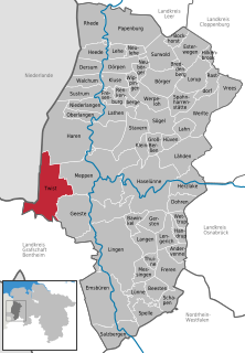
Twist is a municipality in the Emsland district, in Lower Saxony, Germany. It is situated directly on the Dutch border.

Bavarian Rhön Nature Park nature park in Bavaria, Germany

The Bavarian Rhön Nature Park straddles the junction of the German states of Bavaria, Hesse and Thuringia. 70 km² of the total 125 km² area of the nature park has been recognised by UNESCO as part of the Rhön Biosphere Reserve.
The organisation for the promotion of the Bavarian Rhön Nature Park was founded in 1967. On 26 November 1982 the regulation for the Naturpark Bayerische Rhön was issued and, in 1997, the Zweckverband became the Society for the Bavarian Rhön Nature Park and Biosphere Reserve.

Lüneburg Heath Nature Park nature park in Lower Saxony, Germany

Lüneburg Heath Nature Park is a nature park, a form of protected environment, located in the Lüneburg Heath in northern Germany.

Elbhöhen-Wendland Nature Park nature park in Lower Saxony, Germany

The Elbhöhen-Wendland Nature Park, formerly known as the Elbufer-Drawehn Nature Park is a German nature park east of Lüneburg in Lower Saxony.

Lower Oder Valley National Park national park in Brandenburg, Germany

The Lower Oder Valley International Park is a shared German-Polish nature reserve. It comprises the western banks of the Oder river within the Uckermark district in the German state of Brandenburg as well as the steep eastern banks in the Gryfino and Police counties of the Polish West Pomeranian Voivodeship further north.

Drömling landscape in Lower Saxony and Saxony-Anhalt, Germany

The Drömling is a sparsely populated depression on the border of Lower Saxony and Saxony-Anhalt in Germany with an area of about 340 square kilometres (130 sq mi). The larger part belonging to Saxony-Anhalt in the east has been a nature park since 1990. The former swampland was transformed by drainage from a natural into a cultural landscape in the 18th century under the direction of Frederick the Great of Prussia. Today the depression, with its waterways, the Mittelland Canal and the rivers Aller and Ohre is a refuge for rare or endangered species of animal and plant. Most of the area is now made up of nature reserves and protected areas. Nearby towns include Oebisfelde and Wolfsburg.

Steinhuder Meer Nature Park nature park in Lower Saxony, Germany

The Steinhuder Meer Nature Park, with northwest Germany's largest inland lake, the Steinhuder Meer, at its heart, covers an area of 310 square kilometres (120 sq mi) within the districts of Nienburg and Schaumburg and the region of Hanover. The sponsor of the nature park, founded in 1974, is Hanover Region.

Dümmer Nature Park nature park in Lower Saxony and North Rhine-Westphalia, Germany

The Dümmer Nature Park in North Germany is located in the Lower Saxon districts of Diepholz and Vechta and the North Rhine-Westphalian district of Minden-Lübbecke. It is about 34 kilometres (21 mi) northeast of Osnabrück and lies between Diepholz and Bohmte, Bersenbrück and Rahden.

Aukrug Nature Park nature park in Schleswig-Holstein, Germany

The Aukrug Nature Park is a nature park in north Germany with an area of 380 square kilometres (150 sq mi). It lies in the centre of the state of Schleswig-Holstein in the region of Holstein. It is sponsored by an association formed by the 2 districts.

Thuringian Forest Nature Park nature park in Thuringia, Germany

The Thuringian Forest Nature Park is one of the two nature parks in the state of Thuringia, Germany.

Bourtange moor Bog area in northern Germany and Netherlands

The Bourtanger Moor was a bog in eastern parts in the Dutch provinces of Drenthe and Groningen and the bordering German districts of Bentheim and Emsland. A remaining stretch on the border between Drenthe and the districts Emsland and Betheim is now a nature reserve, the Internationaler Naturpark Bourtanger Moor-Bargerveen.

Rotes Luch fen area in Brandenburg, Germany

Rotes Luch is a reclaimed fen area, known locally as a luch, and extends to a width of about 1 kilometre (0.62 mi) over a length of approximately 10 kilometres (6.2 mi) from southwest to northeast. It is located in the southwestern corner of the nature reserve Märkische Schweiz of Brandenburg, Germany.

Lechtal valley

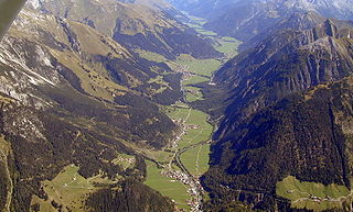
The Lechtal is an alpine valley in Austria, the greater part of which belongs to the state of Tyrol and the smaller part to Vorarlberg. The Lech river flows through the valley.

Teutoburg Forest / Egge Hills Nature Park nature park in North Rhine-Westphalia, Germany

The Teutoburg Forest / Egge Hills Nature Park is a nature park founded in 1965 in the northeast of the German state of North Rhine-Westphalia. After being expanded in 2008, the nature park in the southern Teutoburg Forest and Egge Hills has an area of 2,711 km2, making it the largest in the state and the sixth largest in Germany.

Hessian Rhön Nature Park nature park in Hesse, Germany

The Hessian Rhön Nature Park lies east of Fulda in East Hesse on the border with Thuringia and Bavaria and has and area of 70 km². Together with the Bavarian Rhön Nature Park it is part of the cross-border Rhön Biosphere Reserve.

References

  1. "Bourtanger Moor Barger Veen Nature Park". protectedplanet.net.
  2. "Bourtanger Moor Barger Veen Nature Park". protectedplanet.net.