Landkreis Emsland is a district in Lower Saxony, Germany named after the river Ems. It is bounded by the districts of Leer, Cloppenburg and Osnabrück, the state of North Rhine-Westphalia, the district of Bentheim in Lower Saxony, and the Netherlands.

The municipalities of Sweden are its lower-level local government entities. There are 290 municipalities which are responsible for a large proportion of local services, including schools, emergency services and physical planning.

An unincorporated area is a region not governed by a local municipal corporation. Similarly, an unincorporated community is a settlement not governed by its own local municipal corporation, but is administered as part of larger administrative divisions, such as a township, parish, borough, county, city, canton, state, province, or country. Occasionally, municipalities dissolve or disincorporate, which may happen if they become fiscally insolvent, and services become the responsibility of a higher administration. Widespread unincorporated communities and areas are a distinguishing feature of the United States and Canada. Most other countries of the world have either no unincorporated areas at all, or these are very rare; typically remote, outlying, sparsely populated, or uninhabited areas.

Sakarya is a province in Turkey, located on the coast of Black Sea. The Sakarya River creates a webbing of estuaries in the province. Sakarya is located in the Marmara Region. Its adjacent provinces are Kocaeli to the west, Bilecik to the south, Bolu to the southeast, and Düzce to the east.

Obec is the Czech and Slovak word for a municipality. The literal meaning of the word is "commune" or "community". It is the smallest administrative unit that is governed by elected representatives. Cities and towns are also municipalities.

Thesaban are the municipalities of Thailand. There are three levels of municipalities: city, town, and sub-district. Bangkok and Pattaya are special municipal entities not included in the thesaban system.

The municipality is the basic local administrative division in Spain together with the province.
Spelle is a Samtgemeinde in the district Emsland in Lower Saxony, Germany. Its seat is in the municipality Spelle.
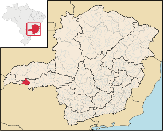
Itapagipe is a municipality in the west of the Brazilian state of Minas Gerais. As of 2020 the population was 15,379 in a total area of 1,795 km². It became a municipality in 1885.
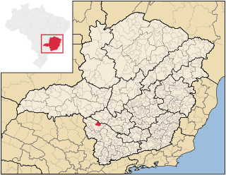
São João Batista do Glória is a Brazilian municipality located in the southwest of the state of Minas Gerais. Its population as of 2020 was 7,498 people living in a total area of 553 km². The city belongs to the meso-region of Sul e Sudoeste de Minas and to the micro-region of Passos. It became a municipality in 1948.
Nicholas II of Tecklenburg was the ruling Count of Tecklenburg from 1388 until his death.
The 2014–15 season of the Niedersachsenliga, the highest association football league in the German state of Lower Saxony, was the seventh season of the league at tier five (V) of the German football league system.

Mittelems is an electoral constituency represented in the Bundestag. It elects one member via first-past-the-post voting. Under the current constituency numbering system, it is designated as constituency 31. It is located in western Lower Saxony, comprising the Grafschaft Bentheim district and the southern part of the Emsland district.


