
Mount Eden is a suburb in Auckland, New Zealand whose name honours George Eden, 1st Earl of Auckland. It is 4 kilometres (2.5 mi) south of the Central Business District (CBD). Mt Eden Road winds its way around the side of Mount Eden Domain and continues to weave back and forth as it descends into the valley; it runs south from Eden Terrace to Three Kings. Mt Eden village centre is located roughly between Valley Road and Grange Road. The domain is accessible on foot from many of the surrounding streets, and by vehicle from Mt Eden Road. The central focus of the suburb is Maungawhau / Mount Eden, a dormant volcano whose summit is the highest natural point on the Auckland isthmus.

Mount Albert is an inner suburb of Auckland, New Zealand, which is centred on Ōwairaka / Mount Albert, a local volcanic peak which dominates the landscape. In the past Mt. Albert also referred to the 2,500 acre borough that was created in 1911 on the outskirts of Auckland City. Mt. Albert was also one of the original five wards within the Mt. Albert Borough. The suburb is located seven kilometres to the southwest of the Central Business District (CBD).

Mount Roskill is a suburban area in the city of Auckland, New Zealand. It is named for the volcanic peak Puketāpapa.
New Zealand Māori rugby league team is a rugby league representative side made up of New Zealand Māori players. The side represents the New Zealand Māori Rugby league. Like its union counterpart, the rugby league team previously competed in international competitions.

Morningside is a suburb of Auckland, New Zealand. It lies four kilometres south-west of the city centre, close to Eden Park and Western Springs Reserve.
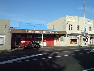
Sandringham is a suburb of Auckland, New Zealand. It is a multi-ethnic suburb with a population of over 12,000.

Wesley is a suburb of Auckland, New Zealand, located in the south-west of the Auckland isthmus. The area is a part of the Oakley Creek catchment, and in the 19th and early 20th centuries was primarily swampland owned by the Weslayan Mission. The New Zealand Government developed Wesley as a state housing area in the 1940s and 1950s.

Owairaka is a suburb of New Zealand's largest city, Auckland. It is under the local governance of the Auckland Council. The area was primarily rural until the 1930s, when the area experienced suburban growth. Owairaka is known for the Owairaka Athletic Club, a club that came to prominence in the 1960s, due to the success of coach Arthur Lydiard and athletes Murray Halberg and Peter Snell.

Kingsland is an inner-city suburb of Auckland, the largest and most populous urban area in New Zealand. Kingsland is under the local governance of the Auckland Council. It is the home of Eden Park, New Zealand's largest stadium, which hosted the finals for the 2011 Rugby World Cup. Kingsland has a village centre that contains a series of shops, restaurants, pubs and monthly markets.

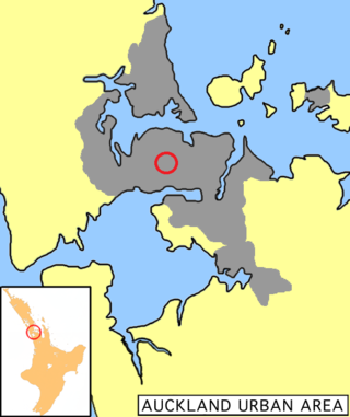
The Auckland isthmus, also known as the Tāmaki isthmus, is a narrow stretch of land on the North Island of New Zealand in the Auckland Region, and the location of the central suburbs of the city of Auckland, including the CBD. The isthmus is located between two rias : the Waitematā Harbour to the north, which opens to the Hauraki Gulf / Tīkapa Moana and Pacific Ocean, and the Manukau Harbour to the south, which opens to the Tasman Sea. The isthmus is the most southern section of the Northland Peninsula.

Fowlds Park is a small public reserve in the northern part of Mount Albert, in Auckland City.

Oakley Creek is a creek in Auckland, New Zealand. While heavily human-modified, it has a number of important ecological features, such as having the only natural waterfall on the Auckland isthmus.

Ōwairaka / Mount Albert, also known as Te Ahi-kā-a-Rakataura, is a volcanic peak and Tūpuna Maunga which dominates the landscape of the Owairaka and Mount Albert suburbs of Auckland.

Greenwoods Corner is an Auckland neighbourhood located within the suburb of Epsom, situated to the south of Newmarket and to the north of Royal Oak, at the intersection of Pah Road and Manukau Road. It is settled in the lee of Maungakiekie / One Tree Hill and serves as a convenient launching point for the area's many attractions. Cornwall Park with Maungakiekie and the Stardome Observatory, Alexandra Park with its harness-racing track, and Monte Cecilia Park with the Pah Homestead and TSB Bank Wallace Arts Centre are all a convenient distance from Greenwoods Corner.
Eden Valley is an inner-city suburb of Auckland, the largest and most populous urban area in New Zealand. The suburb grew around Dominion Road, one of the Auckland's main arterial routes. Eden Valley's commercial hub is made up of a collection of businesses, shops, and dining options that service the area. The eclectic collection of shop fronts and signage on Dominion Road has aptly been described as, "colour and chaos". The "colour and chaos" of the commercial hub is strongly contrasted by the surrounding residential area. Eden Valley is characterized by heritage buildings that house modern day businesses, a residential area that has a range of late Victorian, Edwardian and transitional bay villas, and basalt and scoria stone walls that give the area a long established feel.

Albert-Eden is a local government area in Auckland, in New Zealand's Auckland Region. It is governed by the Albert-Eden Local Board and Auckland Council, and is located within the council's Albert-Eden-Puketāpapa Ward.

The Tūpuna Maungao Tāmaki Makaurau are 14 volcanic cones that hold great historical, spiritual, ancestral and cultural significance to the 13 Māori iwi and hapū of Ngā Mana Whenua o Tāmaki Makaurau, who have owned them since 2014.
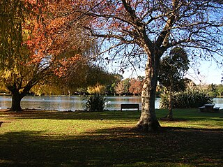
Western Springs Reserve, also known as Western Springs Lakeside Te Wai Ōrea, consists of a sanctuary for wildlife, surrounding a lake fed by the natural springs. There are walking paths surrounding the lake with bridges going across sections of it. Auckland Zoo, Museum of Transport & Technology and Western Springs Stadium are all situated around the park.

New North Road is a street in the central and western Auckland isthmus, New Zealand, connecting Upper Symonds Street in Eden Terrace to Avondale. The road runs parallel to Great North Road, located to the north, and crosses Dominion Road, the Western Line at Morningside and runs above the Waterview Tunnel section of the Southwestern Motorway at Mount Albert.

St Lukes is a suburb of New Zealand's largest city, Auckland. It is under the local governance of the Auckland Council. After Westfield St Lukes opened in 1972, the area developed into a major commercial area of the Auckland isthmus.


