Related Research Articles

Timberville is a town in Rockingham County, Virginia, United States. The population was 2,522 at the 2010 census, which was a significant increase from the 1,739 reported in the 2000 census. It is part of the Harrisonburg Metropolitan Statistical Area.
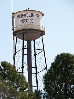
Mosquero is a village in Harding and San Miguel counties in the U.S. state of New Mexico. The population was 93 at the 2010 census, down from 120 in 2000. It is the county seat of Harding County; only a small portion of the village extends into San Miguel County.

Sandy Gulch is a small community in Calaveras County, California, just southwest of West Point on State Route 26. It lies at an elevation of 2592 feet above sea level and is located at 38°22′49″N120°31′58″W. The community is in ZIP code 95248 and area code 209.

Alder Gulch is a place in the Ruby River valley, in the U.S. state of Montana, where gold was discovered on May 26, 1863, by William Fairweather and a group of men including Barney Hughes, Thomas Cover, Henry Rodgers, Henry Edgar and Bill Sweeney who were returning to the gold fields of Grasshopper Creek, Bannack, Montana. They were on their way to Yellowstone Country from Bannack but were waylaid by a band of Crow Indians. After being ordered out of Crow hunting grounds, they crossed the East Slope of the Tobacco Root Mountains and camped for the night in Elk Park, where William "Bill" Fairweather and Henry Edgar discovered gold, while the remaining party was out hunting for meat. Agreeing to keep the new discovery quiet the group of miners returned to the town of Bannack for supplies. However, word leaked out about the new strike, and miners followed the Fairweather party out of town. The party stopped at the Point of Rocks, part way between Bannack and Alder Gulch, and established the Fairweather Mining District in a miners meeting. It was agreed that the discoverers were entitled to two claims and first choice. The first stampede of miners reached Alder Gulch June 6, 1863, and the population swelled to over 10,000 in less than 3 months. The "Fourteen Mile City" ran the length of the gulch, and included the towns of Junction City, Adobe Town, Nevada City, Central City, Virginia City, Montana, Bear Town, Highland, Pine Grove French Town, Hungry Hollow, and Summit. Upon arrival the miners lived in brush wickiups, dugouts and under overhanging rocks until cabins could be built. The first structure built in Virginia City was the Mechanical Bakery. Virginia City, and Nevada City were the centers of commerce during the height of the Alder Gulch gold rush. In the first year the area had over 10,000 people living there. Montana Territory was established in May 1864, and the first territorial capital was Bannack. The capital then moved to Virginia City, where it remained until 1875. The Alder Gulch diggings were the richest gold placer deposits ever discovered, and in three years $30,000,000 was taken from them, with $10,000,000 taken out in the first year. Nowadays, except during summertime, the streets of Virginia City are usually quiet and relatively few visitors find their way to the 16 ton granite monument that marks the spot of that incredible discovery of May 26, 1863.

The Cook–Folsom–Peterson Expedition of 1869 was the first organized expedition to explore the region that became Yellowstone National Park. The privately financed expedition was carried out by David E. Folsom, Charles W. Cook and William Peterson of Diamond City, Montana, a gold camp in the Confederate Gulch area of the Big Belt Mountains east of Helena, Montana. The journals kept by Cook and Folsom, as well as their personal accounts to friends were of significant inspirational value to spur the organization of the Washburn-Langford-Doane Expedition which visited Yellowstone in 1870.
Copper Mine Gulch is a valley in Marin County, California, United States, which is associated with a small stream.
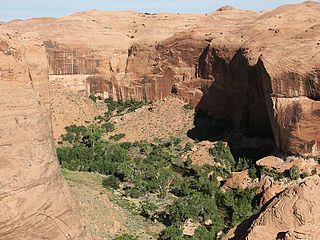
Coyote Gulch is a tributary of the Escalante River, located in Garfield and Kane Counties in southern Utah, in the western United States. Over 25 mi (40 km) long, Coyote Gulch exhibits many of the geologic features found in the Canyons of the Escalante, including high vertical canyon walls, narrow slot canyons, domes, arches, and natural bridges. The upper sections of Coyote Gulch are located within the Grand Staircase-Escalante National Monument while its lower sections are located in the Glen Canyon National Recreation Area.

Lacy is an unincorporated community in Halbert Township, Martin County, in the U.S. state of Indiana.
The Pattullo Range is a subrange of the Hazelton Mountains, located south of Tesla Lake and northeast of Bella Coola in northern British Columbia, Canada. Its highest summit is Tsaydaychuz Peak, 2758 m.

Woolsey Flat is a former settlement in Nevada County, California. Woolsey Flat is located 4 miles (6.4 km) north-northeast of North Bloomfield. It is situated at an elevation of 4,199 ft (1,280 m) above sea level.

South Woodstock is an unincorporated village and census-designated place (CDP) in the town of Woodstock in Windsor County, Vermont, United States. Its elevation is 1,040 feet (320 m), and it is located at 43°33′56″N72°31′56″W, in the Kedron Valley.
Matherville is an unincorporated community located in Wayne County, Mississippi, United States. Matherville is located in the northwest corner of Wayne County, just to the west of the state of Alabama. The elevation of Matherville is 289 feet (88 m).
Home Valley is an unincorporated community in the Columbia River Gorge National Scenic Area along the Columbia River in Skamania County, Washington, United States.

Chiawuli Tak is both a census-designated place (CDP) as well as a populated place in Pima County, Arizona, United States. Chiawuli Tak means "the barrel cactus sits" in the O'odham language. It is also unofficially known as Geowic, Jeowic, or Tjeavolitak. The population was 78 at the 2010 census.
Horton Town is an unincorporated community in Washington County, in the U.S. state of Missouri.
Walnut Creek is a tributary stream of Animas Creek within Hidalgo County, New Mexico.

Big Rock is an unincorporated community in Liberty Township, Jackson County, Ohio, United States. It is located northwest of Jackson at the intersection of Big Rock Road and Big Run Road, at 39°06′06″N82°46′35″W.
References
- ↑ U.S. Geological Survey Geographic Names Information System: Gringo Gulch
- ↑ Monmonier, Mark (2008). From Squaw Tit to Whorehouse Meadow: How Maps Name, Claim, and Inflame. University of Chicago Press. p. 39. ISBN 978-0226534640.
Coordinates: 31°33′56″N110°46′35″W / 31.56556°N 110.77639°W