Grinzing

Last updated • 4 min readFrom Wikipedia, The Free Encyclopedia
Grinzing
Coat of armsMap
Grinzing wappen.png
Karte Wien-Grinzing.png

Location: 48°15′16″N16°20′34″E / 48.25444°N 16.34278°E / 48.25444; 16.34278

Contents

Grinzing (German pronunciation: [ˈɡʁɪnt͡sɪŋ] ) was an independent municipality until 1892 and is today a part of Döbling, the 19th district of Vienna. [1]

Geography

View of Grinzing with the Wienerwald in the back, around 1900 Wien-Grinzing from south 1900.jpg
View of Grinzing with the Wienerwald in the back, around 1900

Location

Grinzing lies in the northwest of Vienna and, with an area of 613.52 hectares, is the largest suburb in the district of Döbling. To the northeast, it borders on Josefsdorf; the border continues along the Wildgrube and the Schreiberbach stream towards the east, where it branches along the Springsiedelgasse and the Neugebauerweg to the south. The border then runs along the Hungerbergstraße to mark the boundary to Unterdöbling, before following the course of the Kaasgraben, which divides Grinzing from Sievering in the east. Finally, the border turns northwestward and continues via the Himmelstraße and the Spießweg to the edge of the city of Vienna, which separates Grinzing from Weidling.

Topography

Grinzing is characterised by numerous forested ridges of the Wienerwald (Vienna Woods). Hermannskogel, the tallest hill in Vienna, lies on the border to Lower Austria. There are also other well-known hills, including the Reisenberg, Latisberg, Vogelsangberg, Hungerberg, and Pfaffenberg. Grinzing’s woods are home to several streams, including the Schreiberbach, which runs untouched through the Wildgrube almost as far as Nussdorf. The Reisenbergbach begins to the west of the Reisenberg and makes its way through Grinzing, where it flows into a canal. The headwaters of the Arbesbach also lie in the west of Grinzing. A further notable characteristic of the area are its grapevines, especially on the Reisenberg and Hungerberg hills.

Etymology

The name "Grinzing" means "of the people who belong to a man named Grinzo". Many German words ending in "ing" are indicators of membership to a Sippe . A version of the name "Grinzing" first appears in 1114, when it was called Grinzigan.

History

Beim Heurigen in Grinzing, painting by Rudolf Alfred Hoger (1900) Rudolf Alfred Hoger Beim Heurigen.jpg
Beim Heurigen in Grinzing, painting by Rudolf Alfred Höger (1900)
The centre of Grinzing with Grinzing Parish Church Die Grinzinger Kirche - panoramio.jpg
The centre of Grinzing with Grinzing Parish Church

The village of Grinzing came into the possession of the noble house Grunzinger in the 11th century. The Grunzinger built the Trummelhof, the remains of which can still be seen in the house at number 30 in the Cobenzlgasse. This former manor was supposedly thus named (Trümmer = rubble, Hof = court, yard) because it was built on top of Roman ruins.

The village was inhabited primarily by vintners and day labourers, who served land-owning monasteries and rich members of Vienna’s bourgeoisie. In the 14th century, the last of the Grunzinger, Rüdiger von Gründsing, died, and in 1350 he was buried in the Minoritenkirche in Vienna. Thereafter, Grinzing fell within the jurisdiction of the Klosterneuburg Monastery, which retained its authority over the area into the 19th century. The Grinzing Parish Church "Zum heiligen Kreuz" (The Holy Cross) was erected in 1426.

Grinzing suffered greatly in the centuries following the Middle Ages. In 1484, Matthias Corvinus laid waste to the village, while in 1529 the Ottoman Turks inflicted heavy damage. In 1604, a major fire destroyed sections of the village and in 1683 the Turks once again ruined the newly reconstructed houses. Grinzing nonetheless developed better than its neighbours. In 1713, there were 70 houses, but the plague hit the village hard. More than half of these houses were infected, and 129 people died. This seriously stunted the village’s growth.

In 1783, the church in Grinzing was elevated to the status of a parish church; it was financed through the dissolution of several religious orders in the area by Joseph II. However, the pace of development in the village remained slow in the following decades. In 1795, there were 83 houses. In 1822 there were 99 houses but there were no further additions until 1835. In 1831, Grinzing numbered 99 houses with 835 inhabitants and was thus barely larger than it had been in 1795. The rate of growth increased after the 1830s, and by 1890, the population had grown to 1,421 people in 209 houses.

In 1892, Grinzing was incorporated into the city of Vienna. The area as far as the Wienerwald ridge was included along with Oberdöbling, Unterdöbling, Kahlenbergerdorf, Nußdorf, Heiligenstadt, Sievering and Josefsdorf in the 19th district, Döbling, while the rest of Grinzing was allocated to Weidling.

Grinzing’s reputation is based on its vineyards and numerous Heurigen —the traditional cafes serving wine and must (grape juice) which remain a tourist attraction to this day.

Economy

Riede Kleben vineyard in Grinzing Riede Kleben IV.jpg
Riede Kleben vineyard in Grinzing

The traditional importance of viticulture and logging in the local economy during becomes evident when one examines the distribution of available land in Grinzing in 1826. At that time, 45 percent of the land was covered by the woodlands belonging to the Klosterneuburg Monastery. Another 23 percent was used for vineyards. Agriculture played a secondary role, covering barely 10 percent of the land. Beer production was also important at times; a brewery founded in the Trummelhof in 1814 operated intermittently until 1831.

Sights

Gustav Mahler's grave in the Grinzing cemetery Grinzinger Friedhof - Gustav Mahler.jpg
Gustav Mahler's grave in the Grinzing cemetery

In addition to Grinzing’s numerous Heurigen, the parish church and the Kaasgrabenkirche are worth a visit. The large area covered by the Wienerwald is home to the Habsburgwarte on the Hermannskogel hill as well as a monument to Karl Lueger and the “Cobenzl” restaurant on the Reisenberg hill.

The Grinzing Cemetery (Grinzinger Friedhof) is home to the graves of Julius Deutsch, Gustav Mahler, Alma Mahler-Werfel, Attila Hörbiger, Paula Wessely, Heimito von Doderer, Ida Krottendorf and Thomas Bernhard.

Notes

  1. Wien.gv.at webpage (see below: References).

Related Research Articles

<span class="mw-page-title-main">Hermannskogel</span> Highest mountain in Vienna, Austria

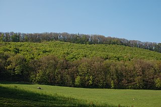
The Hermannskogel is a hill in Döbling, the 19th district of Vienna. At 542 metres above sea level, it is the highest natural point of Vienna. It lies on the border to Lower Austria.

<span class="mw-page-title-main">Josefstadt</span> 8th District of Vienna in Austria

Josefstadt is the eighth district of Vienna. It is near the center of Vienna and was established as a district in 1850, but borders changed later. Josefstadt is a heavily populated urban area with many workers and residential homes. It has a population of 24,279 people (2014). With an area of 1.08 km2, Josefstadt is the smallest district in Vienna, and was named after the Holy Roman Emperor Joseph I.

<span class="mw-page-title-main">Floridsdorf</span> 21st District of Vienna in Austria

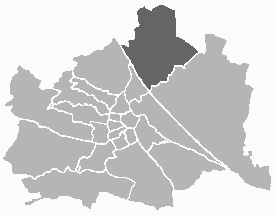
Floridsdorf is the 21st district of Vienna, located in the northern part of the city and comprising seven formerly independent communities: Floridsdorf, Donaufeld, Greater Jedlersdorf, Jedlesee, Leopoldau, Stammersdorf, and Strebersdorf.

<span class="mw-page-title-main">Kahlenberg</span>

The Kahlenberg is a mountain located in the 19th District of Vienna, Austria (Döbling).

<span class="mw-page-title-main">Hernals</span> 17th District of Vienna in Austria

Hernals is the 17th district of Vienna, Austria . Hernals is in northwest Vienna. It was annexed in 1892 out of the townships of Hernals, Dornbach, and Neuwaldegg.

<span class="mw-page-title-main">Döbling</span> 19th District of Vienna in Austria

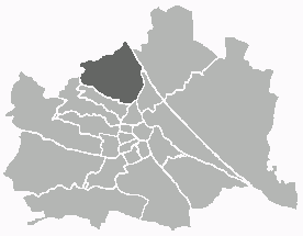
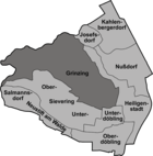
Döbling is the 19th district in the city of Vienna, Austria. It is located in the north of Vienna, north of the districts Alsergrund and Währing. Döbling has some heavily populated urban areas with many residential buildings, and borders the Vienna Woods. It includes some of the most expensive residential areas such as Grinzing, Sievering, and Neustift am Walde, and is home to many Heurigen taverns. There are some large Gemeindebauten, including Vienna's most famous, the Karl-Marx-Hof.

<span class="mw-page-title-main">Ottakring</span> 16th District of Vienna in Austria

Ottakring is the 16th District in the city of Vienna, Austria. It is located west of the central districts, north of Penzing and south of Hernals. Ottakring has some heavily populated urban areas with many residential buildings. It was formed from the independent villages of Ottakring and Neulerchenfeld in 1892.

<span class="mw-page-title-main">Heiligenstadt, Vienna</span> Place in Vienna, Austria

Heiligenstadt was an independent municipality until 1892 and is today a part of Döbling, the 19th district of Vienna, Austria.

<span class="mw-page-title-main">Kahlenbergerdorf</span>

Kahlenbergerdorf was an independent municipality until 1892 and is today a part of Döbling, the 19th district of Vienna. It is also one of the 89 Katastralgemeinden.

<span class="mw-page-title-main">Sievering</span> Suburb of Vienna

Sievering is a suburb of Vienna and part of Döbling, the 19th district of Vienna. Sievering was created in 1892 out of the two erstwhile independent suburbs Untersievering and Obersievering. These still exist as Katastralgemeinden.

<span class="mw-page-title-main">Nussdorf, Vienna</span> Suburb of Döbling, Vienna, Austria

Nussdorf was a separate municipality until 1892 and is today a suburb of Vienna in the 19th district of Döbling.

<span class="mw-page-title-main">Salmannsdorf</span>

Salmannsdorf is a part of Döbling, the 19th district of Vienna.

<span class="mw-page-title-main">Oberdöbling</span>

Oberdöbling was an independent municipality until 1892 and is today a part of Döbling, the 19th district of Vienna. It is also one of the 89 Katastralgemeinden.

<span class="mw-page-title-main">Unterdöbling</span>

Unterdöbling was an independent municipality until 1892 and is today a part of Döbling, the 19th district of Vienna. It is also one of the 89 Katastralgemeinden.

<span class="mw-page-title-main">Josefsdorf</span> Quarter of Vienna

Josefsdorf was an independent municipality until 1892 and is today a part of Döbling, the 19th district of Vienna. It is also one of the 89 Katastralgemeinden.

<span class="mw-page-title-main">Neustift am Walde</span>

Until 1892, Neustift am Walde was an independent municipality on the outskirts of Vienna, Austria. Today it is part of Döbling, the 19th district of Vienna. It is also one of the 89 Katastralgemeinden.

<span class="mw-page-title-main">Döbling Cemetery</span>

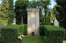
The Döbling Cemetery is a cemetery in the 19th district of Döbling in Vienna, Austria.

<span class="mw-page-title-main">Heiligenstadt Parish Church St. Michael</span> Parish church in Döbling, Vienna, Austria

The Parish Church St. Michael's is a Roman Catholic parish church in the suburb of Heiligenstadt in the 19th district of Vienna, Döbling. It is dedicated to the Archangel Michael.

<span class="mw-page-title-main">Heiligenstadt St. James's Church</span>

St. James's Church is one of two Roman Catholic churches in the parish of Heiligenstadt in the 19th district of Vienna, Döbling. It stands at the Pfarrplatz and is dedicated to James, son of Zebedee.

<span class="mw-page-title-main">Grinzing Parish Church</span> Parish church

The Grinzing Parish Church is the Roman Catholic parish church of Grinzing in the 19th district of Döbling, western Vienna, Austria.

References

Commons-logo.svg Media related to Grinzing at Wikimedia Commons