
Saint Anthony Falls, or the Falls of Saint Anthony, located at the northeastern edge of downtown Minneapolis, Minnesota, was the only natural major waterfall on the Mississippi River. Throughout the mid-to-late 1800s, various dams were built atop the east and west faces of the falls to support the milling industry that spurred the growth of the city of Minneapolis. In 1880, the central face of the falls was reinforced with a sloping timber apron to stop the upstream erosion of the falls. In the 1950s, the apron was rebuilt with concrete, which makes up the most visible portion of the falls today. A series of locks were constructed in the 1950s and 1960s to extend navigation to points upstream.
The Neponset River is a river in eastern Massachusetts in the United States. Its headwaters are at the Neponset Reservoir in Foxborough, near Gillette Stadium. From there, the Neponset meanders generally northeast for about 29 miles (47 km) to its mouth at Dorchester Bay between Quincy and the Dorchester section of Boston, near the painted gas tank.
There were several historic mills around the metro Atlanta area, for which many of its current-day roads are still named. Most of the mills date back to the 1820s and 1830s, and were built along the area's many streams. The locations of many of these mills are shown on a map of 1875 showing U. S. military operations around Atlanta in 1864. This map is now located in the U. S. Library of Congress but can be seen on the webpage linked here.

The Royal River is a small river, 39 miles (63 km) long, in southern Maine. The river originates in Sabbathday Lake in New Gloucester and flows northeasterly into Auburn and then southerly through New Gloucester, Gray and North Yarmouth into Casco Bay at Yarmouth.

The Pleasant River is a 13.1-mile-long (21.1 km) tributary of the Presumpscot River in the U.S. state of Maine.
A gristmill grinds cereal grain into flour and middlings. The term can refer to either the grinding mechanism or the building that holds it. Grist is grain that has been separated from its chaff in preparation for grinding.

Yarmouth is a town in Cumberland County, Maine, United States, twelve miles north of the state's largest city, Portland. When originally settled in 1636, as North Yarmouth, it was part of the Massachusetts Bay Colony, and remained part of its subsequent incarnations for 213 years. In 1849, twenty-nine years after Maine's admittance to the Union as the twenty-third state, it was incorporated as the Town of Yarmouth.
The historical buildings and structures of Yarmouth, Maine, represent a variety of building styles and usages, largely based on its past as home to almost sixty mills over a period of roughly 250 years. These mills include that of grain, lumber, pulp and cotton. Additionally, almost three hundred vessels were launched by Yarmouth's shipyards in the century between 1790 and 1890, and the homes of master shipwrights and ship captains can still be found throughout the town.

Royal River Park is an urban park in Yarmouth, Maine, United States. It is located to the northwest of the town center, between East Elm Street to the west and Bridge Street to the east. U.S. Route 1 runs through the park via an overpass.

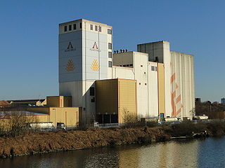
Sparhawk Mill is a former cotton mill on Bridge Street in Yarmouth, Maine, United States. Built in 1840 and made of brick, it is home today to several businesses. The mill stands, just east of the town's Second Falls, on the site of several previous mill buildings, the earliest of which was a wooden mill dating to 1817.

Main Street is a historic street in Yarmouth, Maine, United States. It is part of the 18-mile-long (29 km) State Route 115 (SR 115), the eastern terminus of which is in Yarmouth at the intersection of Marina Road and Lafayette Street (SR 88), at Yarmouth Harbor in the town's Lower Falls neighborhood. Main Street's western terminus is a merging with Walnut Hill Road in North Yarmouth, at which point SR 115 continues west. There are three distinct sections of Main Street : Lower Falls, Brickyard Hollow and Upper Village.

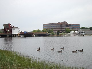
Yarmouth Marina is a natural harbor and estuary of Casco Bay, and is located adjacent to the town of Yarmouth, Maine, United States. It is situated on the Royal River, around 0.5 miles (0.80 km) southeast of the town center, in an area known as Lower Falls. Today it functions solely as a marina.
Bridge Street is a historic street in Yarmouth, Maine, United States. It runs for about 0.36 miles (0.58 km) from Willow Street in the north to the town's Main Street, State Route 115, in the south. The street's elevation is around 75 feet (23 m) at each end, while its middle section, at its crossing of the Royal River, is around 13 feet (4.0 m), a drop of around 62 feet (19 m).
Elm Street is a prominent street in Yarmouth, Maine, United States. It runs for about 2.7 miles (4.3 km) from North Road in the north to Portland Street in the south. The street's addresses are split between "West Elm Street" and "East Elm Street", the transition occurring at Main Street in the Upper Village. Several of its buildings are homes dating to the late 18th and early 19th centuries.

The First Falls are the first of four waterfalls in Yarmouth, Maine, United States. They are located on the Royal River, approximately a mile from its mouth with inner Casco Bay at Yarmouth Harbor and around 0.35 miles (0.56 km) downstream of the Second Falls. The river appealed to settlers because its 45-foot rise in close proximity to navigable water each provided potential waterpower sites. As such, each of the four falls was used to power 57 mills between 1674 and the mid-20th century.

The Third Falls are the third of four waterfalls in Yarmouth, Maine, United States. They are located on the Royal River, approximately 2.8 miles (4.5 km) from its mouth with inner Casco Bay at Yarmouth Harbor, and approximately 0.4 miles (0.64 km) upstream of the Second Falls. The river appealed to settlers because its 45-foot rise in close proximity to navigable water each provided potential waterpower sites. As such, each of the four falls was used to power 57 mills between 1674 and the mid-20th century.

The Royal River Conservation Trust (RRCT) is a volunteer-run conservation group based in Yarmouth, Maine, United States. Established in 1988 and funded by its members, it owns many preserves and trail networks, and has assisted in the creation of town-owned parks and preserves, state parks and state wildlife-management areas. The trust, one of eighty land trusts in Maine, covers seven towns and cities in Androscoggin County and Cumberland County which form the watershed of the Royal River: Yarmouth, North Yarmouth, Pownal, New Gloucester, Gray, Durham and Auburn.

Lower Falls is the colloquial name for the eastern end of Main Street, and part of East Main Street, in Yarmouth, Maine, centered around Main Street's intersection with Portland Street. It is also known as Falls Village or The Falls.

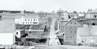
1 Main Street is a historic building in Yarmouth, Maine. It is located in the town's Lower Falls neighborhood, beside the First Falls and near Main Street's intersection with East Main Street. It stands across the Royal River from Grist Mill Park, which was the site of several mills in the 17th century.

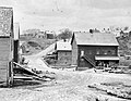 A 19th-century westerly view of one of the former grist mills (right) on the site of today's park
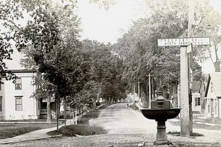
 A panorama of the park from the western side of the river