Grizzly Creek Fire

Last updated

Grizzly Creek Fire
Grizzly Creek Fire - 8.23.20 c.jpg
Grizzly Creek Fire on August 23, 2020
Location Glenwood Canyon, Glenwood Springs, Colorado, United States
Coordinates 39°34′19″N107°15′58″W / 39.572°N 107.266°W / 39.572; -107.266
Statistics [1]
Date(s)August 10, 2020 – December 18, 2020
Burned areaI-70 Glenwood 32,631 acres (13,205 ha)
CauseTruck chains
Map
USA Colorado location map.svg
FireIcon.svg
Location in Colorado

The Grizzly Creek Fire (also called the 120 Fire) [2] was a wildfire that burned 32,631 acres (13,205 ha) in Glenwood Canyon in the state of Colorado in the United States. The fire first ignited on August 10, 2020 and was declared 100% contained on December 18, 2020. The Grizzly Creek fire's proximity to Interstate 70 resulted in a 13-day closure of the interstate. It threatened the Shoshone Generating Station and resulted in the evacuation of residences in the area, as well as closure of recreational land in portions of White River National Forest. The fire was ruled to be human-caused.

Contents

Events

The Grizzly Creek Fire burning near the Shoshone Hydroelectric Generating Station. 2020 08 23-09.27.25.326-CDT.jpg
The Grizzly Creek Fire burning near the Shoshone Hydroelectric Generating Station.

August

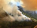
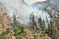
The Grizzly Creek Fire, which was first called the 120 Fire, [2] was first reported around 1:30 PM on August 10, burning in Glenwood Canyon one mile east of Glenwood Springs, Colorado. [1] Fueled by hot, dry, windy weather, the fire began spreading in multiple directions. [3] Witnesses to the fire at its start included people rafting through the canyon and a Colorado Department of Transportation employee who tried to put it out with a fire extinguisher. [4] Its growth towards Interstate 70 resulted in the interstate's closure from Glenwood Springs to Gypsum. By August 12, the fire had crossed both the interstate and the Colorado River. [5] The power plant at the Shoshone Generating Station was evacuated, along with the communities of No Name, Lookout Mountain, and Coulter Creek. [3] The Glenwood Springs Community Center was named an evacuation point to connect evacuees with services and Battle Mountain High School was named an evacuation center. [6] [7] Local roads in the area were also closed, as well as portions of Bureau of Land Management-managed land and portions of White River National Forest. [3] [8] Air support was immediately brought in due to the fire's hard-to-reach location in the canyon. [3]

The fire grew rapidly with Red Flag winds and by the morning of August 13 it spread east towards Bair Ranch and southeast into Devil's Hole Canyon and doubled in size from 6,251 acres (2,530 ha) to 13,441 acres (5,439 ha). It was one percent contained. Highway 82 was closed at Independence Pass due to excessive traffic and accidents resulting from drivers using rural, rugged dirt roads as alternatives to Interstate 70, which remained closed. [9] [10] The next day, on August 14, the Bureau of Land Management closed recreational sites and boat ramps around the southern part of the Colorado River near Dotsero. [11] The fire spotted across Coffee Pot Rd. on August 15, with crews catching the spot fire before it could spread. The fire did continue towards Bair Ranch, with dozer lines being put in place to protect the core of the ranch. [12] Air quality health advisories were put in place for areas east of the fire. [7]

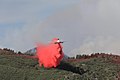
Due to the fire's location near infrastructure, residences and its potential impact on the environment, Burned Area Emergency Response teams arrived early on the scene, on August 19. That same day, it was reported that the Shoshone Hydroelectric Power Plant's service was interrupted by downed transmission lines. [13]

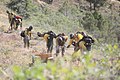
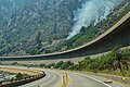
On August 20, evacuation orders were downgraded for residents in the Buck Point area. [14] The next day, containment was achieved from Coffee Pot Road to I-70. [15] That same day, it was announced that Dan Gibbs, the head of Colorado's Department of Natural Resources and a wildland firefighter was fighting the fire near Glenwood Springs. [16]

I-70 was reopened the morning of August 24. [17] Later that day, a flare up along the interstate resulted in a second, temporary closure while helicopters quelled the flare up with water drops. [18] By August 26, the fire was 61 percent contained at 32,060 acres (12,974 ha). [19]

Containment continued to grow and suppression work began in impacted areas, including on Coffee Pot Rd. [20] On the afternoon of August 30, a storm generated wind gusts of 40 MPH, resulting in crews being pulled from fire lines. [21] The fire was determined to be human caused, with further investigation required to determine specificities. [1]

Impact

The Grizzly Creek Fire has impacted infrastructure, transportation and recreational activities in the area, including in White River National Forest.

Closures and evacuations

The Grizzly Creek Fire burning along Interstate 70 on August 11, 2020. 2020 08 12-11.41.54.626-CDT.jpg
The Grizzly Creek Fire burning along Interstate 70 on August 11, 2020.

The Grizzly Creek Fire caused a section of I-70 between Glenwood Springs and Gypsum in Glenwood Canyon to be closed on August 10, 2020. It was reopened by CDOT the morning of August 24, 2020. [22] Local roads were also closed in the area, including Highway 82 which passes over Independence Pass. [3] [9]

The communities of No Name, Lookout Mountain and Coulter Creek were evacuated and the Glenwood Springs Community Center served as an evacuation point. [6] Portions of White River National Forest were also closed, including Glenwood Canyon. [3] [8]

A Union Pacific Railroad passenger and freight line was closed in the area after debris falling caused a rock pile to form on the tracks. [23] Train travel resumed by August 22. [24]

Nearly a year later, the I-70 in Glenwood Canyon was closed again, due to debris flows from the fire damage. [25]

Economic

The closures and evacuations resulted in cancelations on hotel and resort rooms by visitors in Glenwood Springs, exacerbating economic challenges from the COVID-19 pandemic. [9] Due to the closure of Interstate 70 and other roads, local businesses were unable to keep groceries, pet food and other items in stock, resulting in empty shelves. There were also fuel shortages in the area. [26]

Infrastructure

The Shoshone hydroelectric power plant lost transmission lines, resulting in a service interruption. [13]

Environmental

The Colorado River's clarity was impacted with sediment from burned areas being carried into the river from rain. It will take an estimated five to seven years for the river's clarity to return to normal. The increased sediment will impact fishing, rafting and will increase rock slides. The river will begin to dilute where it meets the Roaring Fork River and sediment is expected to be found in Lake Powell. [13]

Investigation

On August 31, the US Forest Service confirmed that the fire was human-caused and that further investigation was required to determine the specific cause. [1]

See also

Related Research Articles

<span class="mw-page-title-main">Eagle Creek Fire</span> Major 2017 wildfire in Columbia Gorge, Oregon

The Eagle Creek Fire was a destructive wildfire in the Columbia River Gorge, largely in the U.S. state of Oregon, with smaller spot-fires in Washington. The fire was started on September 2, 2017, by a 15-year-old boy igniting fireworks during a burn ban. The fire burned 50,000 acres, and burned for three months, before being declared completely contained. As late as May 29, 2018, it was still found smoldering in some areas.

<span class="mw-page-title-main">Pier Fire</span> 2017 wildfire in Tulare County, California

The Pier Fire was a wildfire that burned near Springville and in the Sequoia National Forest, in California in the United States. The fire was reported on August 29, 2017. The cause of the fire is under investigation, but is believed to be human-caused. The fire was completely extinguished on November 29, after it had burned 36,556 acres (148 km2). The fire threatened old growth sequoia trees, the Tule River Indian Reservation, and many small communities in the area.

<span class="mw-page-title-main">Alice Creek Fire</span>

The Alice Creek Fire was a wildfire north of Lincoln in the Lewis and Clark National Forest, located in Lewis and Clark County in Montana in the United States. The fire, started by a lightning strike, was reported on July 22, 2017. The fire burned at least 29,252 acres (118 km2). The Alice Creek Fire crossed the Continental Divide, impacting wildlife, specifically aquatic life, and threatened the Alice Creek Historic District.

<span class="mw-page-title-main">Creek Fire (2017)</span> 2017 wildfire in Southern California, United States

The Creek Fire was a large wildfire that burned in Kagel Canyon and the Angeles National Forest north of Sylmar, a neighborhood in Los Angeles, California, United States, and one of multiple wildfires that broke out across Southern California in December 2017. The Creek Fire burned 15,619 acres (63 km2) and destroyed 123 structures, including 60 homes, before being contained on January 9, 2018, following heavy rainfall from a winter storm. The fire threatened the communities of Santa Clarita, Glendale, Olive View, Lake View Terrace, Sunland-Tujunga, Shadow Hills, Sylmar, Pacoima, Lopez Canyon, and Kagel Canyon, as well as the Olive View–UCLA Medical Center. During the wildfire, 115,000 residents were forced to evacuate their homes.

<span class="mw-page-title-main">Ferguson Fire</span> 2018 wildfire in California

The Ferguson Fire was a major wildfire in the Sierra National Forest, Stanislaus National Forest and Yosemite National Park in California in the United States. The fire was reported on July 13, 2018, burning 96,901 acres (392 km2), before it was 100% contained on August 19, 2018. Interior areas of the fire continued to smolder and burn until September 19, 2018, when InciWeb declared the fire to be inactive. The Ferguson Fire was caused by the superheated fragments of a faulty vehicle catalytic converter igniting vegetation. The fire, which burned mostly in inaccessible wildland areas of the national forest, impacted recreational activities in the area, including in Yosemite National Park, where Yosemite Valley and Wawona were closed. The Ferguson Fire caused at least $171.2 million in damages, with a suppression cost of $118.5 million and economic losses measuring $52.7 million. Two firefighters were killed and nineteen others were injured in the fire.

<span class="mw-page-title-main">Cranston Fire</span> 2018 wildfire in California

The Cranston Fire was a wildfire that burned in southwest Riverside County, California, in the United States. The fire was started on July 25, 2018, by Brandon M. McGlover, in an act of arson. The fire burned a total of 13,139 acres (53 km2), before it was fully contained on August 10. The Cranston Fire impacted the communities of Idyllwild and Mountain Center, as well as recreational activities in the Lake Hemet area, San Bernardino National Forest and Mount San Jacinto State Park. Over 7,000 people were evacuated due to the Cranston Fire.

<span class="mw-page-title-main">Walker Fire (2019)</span> 2019 wildfire in California

The Walker Fire was a wildfire that burned near Genesee Valley in the Plumas National Forest approximately 11 miles east of the community of Taylorsville in Plumas County, California. The blaze was reported on Wednesday, September 4, 2019 and immediately expanded in size over its several days of burning. The fire actively threatened homes from Genesee Valley to Antelope Road.

<span class="mw-page-title-main">Taboose Fire</span>

The Taboose Fire was a wildfire burning in Inyo National Forest, southwest of Big Pine and northwest of Aberdeen in Inyo County in the state of California, in the United States. The fire started September 4, 2019 and on October 7, it had burned 10,296 acres (4,167 ha) and was 75 percent contained. The cause of the fire was lightning. Select trails, campgrounds and roads in Inyo National Forest, Sequoia National Park and Kings Canyon National Park had been closed due to the fire. The community of Baxter Ranch was under mandatory evacuation.

<span class="mw-page-title-main">Lime Fire</span>

The Lime Fire was a wildfire located west of Interstate 5 and north of Highway 96 in the Klamath National Forest's Lime Gulch area in Siskiyou County. The fire was started as the result of a lightning strike during a thunderstorm. As of September 17, the fire has burned 1,862 acres (754 ha) and is 96 percent contained. Evacuation warnings are in place for the area between Ash Creek and Gottsville, warning to take "extreme caution" along Highway 96. Portions of Klamath National Forest are closed due to the fire.

<span class="mw-page-title-main">Mangum Fire</span> 2020 Arizona wildfire

The Mangum Fire was a wildfire burning in Kaibab National Forest in Arizona in the United States. The fire, which started on June 8, 2020 approximately 16 miles north of the North Rim of Grand Canyon National Park, burned a total of 71,450 acres (28,915 ha). The fire threatened the community of Jacob Lake, Arizona, resulting in its evacuation. Select highways were closed, including Highway 67, which resulted in closure of the North Rim of the Grand Canyon. Additionally, areas of the Paria Canyon-Vermilion Cliffs Wilderness were inaccessible due to closures. Four buildings were destroyed, including two historic cabins. The exact cause of the fire remains under investigation, however, fire officials have confirmed it was human caused.

<span class="mw-page-title-main">East Canyon Fire</span>

The East Canyon Fire was a wildfire burning in La Plata and Montezuma Counties in Colorado in the United States. The fire was the largest of many small fires started by a lightning storm and was first reported on June 14, 2020. The East Canyon Fire burned 2,905 acres (1,176 ha) and was contained on June 27, 2020. The fire resulted in the closure a portion of Highway 160 and mandatory evacuations of a campground and residences in the area.

<span class="mw-page-title-main">Canal Fire</span>

The Canal Fire was a wildfire that burned Millard County in Utah in the United States. First reported on June 26, 2020, the fire burned 78,065 acres (31,592 ha) on public land, including Fishlake National Forest and land owned by the Bureau of Land Management. Started by a lightning strike, the fire was contained on June 27, only to escape containment on June 28 due to strong winds. The fire led to the mandatory evacuation of Fool Creek Peak and Leamington, Utah. It was contained on July 11, 2020.

<span class="mw-page-title-main">Pine Gulch Fire</span>

The Pine Gulch Fire was a wildfire that burned in Mesa County and Garfield County, Colorado in the United States. The fire was started by a lightning strike and first reported on July 31, 2020 and quickly grew, resulting in the fire being named the largest wildfire in Colorado history, surpassing the 2002 Hayman Fire. Almost seven weeks later, it was surpassed by the Cameron Peak Fire in Larimer County.

<span class="mw-page-title-main">Lake Fire (2020)</span> 2020 wildfire in Los Angeles County, California

The Lake Fire was a wildfire that burned during the 2020 California wildfire season in the Angeles National Forest in Los Angeles County in the state of California in the United States. The fire, which was first reported on August 12, 2020, burned 31,089 acres (12,581 ha) near Lake Hughes. It was fully contained on September 28. The cause of the fire remains unknown. The fire has damaged 3 structures, destroyed 12 structures and 21 outbuildings, and injured 4 firefighters.

<span class="mw-page-title-main">Loyalton Fire</span> 2020 wildfire that burnt on the California-Nevada border

The Loyalton Fire was a wildfire burning in Lassen, Plumas and Sierra County, California, and Washoe County, Nevada. The fire burned about 47,029 acres (19,032 ha) in the Tahoe National Forest and Humboldt-Toiyabe National Forest before being fully contained on September 14, 2020.

<span class="mw-page-title-main">North Complex Fire</span> A large complex wildfire in Northern California in 2020

The North Complex Fire was a massive wildfire complex that burned in the Plumas National Forest in Northern California in the counties of Plumas and Butte. 21 fires were started by lightning on August 17, 2020; by September 5, all the individual fires had been put out with the exception of the Claremont and Bear Fires, which merged on that date, and the Sheep Fire, which was then designated a separate incident. On September 8, strong winds caused the Bear/Claremont Fire to explode in size, rapidly spreading to the southwest. On September 8, 2020, the towns of Berry Creek and Feather Falls were immediately evacuated at 3:15 PM PDT with no prior warning, By September 9, 2020, the towns of Berry Creek and Feather Falls had been leveled, with few homes left standing. The fire threatened the city of Oroville, before its westward spread was stopped. The fire killed 16 people and injured more than 100. Among the 16 fatalities was a 16-year-old boy. The complex burned an estimated 318,935 acres (129,068 ha), and was 100% contained on December 3. The fire was managed by the U.S. Forest Service in conjunction with Cal Fire, with the primary incident base in Quincy. The North Complex Fire was the sixth-largest in California's modern history, and the deadliest fire in the 2020 California wildfire season.

<span class="mw-page-title-main">Cameron Peak Fire</span>

The Cameron Peak fire was a wildfire that started near Chambers Lake, Colorado, 25 miles (40 km) east of Walden and 15 miles (24 km) southwest of Red Feather Lakes near Cameron Pass on August 13, 2020, and was declared 100% contained on December 2, 2020. The fire burnt 208,663 acres through the Arapaho and Roosevelt National Forests in Larimer and Jackson Counties and Rocky Mountain National Park. At its peak, the fire forced the evacuation of over 6,000 residents in Estes Park, Chambers Lake, Rustic, Glacier View Meadows, Red Feather Lakes, Masonville, Glen Haven, Spring Canyon, various small communities along Highway 14, Stove Prairie Landing Road, as well as the Colorado State University Mountain Campus and had over 1,000 personnel fighting the fire. 469 structures were destroyed by the fire, including 220 outbuildings and 42 primary residences. The fire became the largest wildfire in Colorado history, surpassing the Pine Gulch Fire, which had set the same mark just seven weeks prior.

<span class="mw-page-title-main">Salt Fire (2021)</span> 2021 wildfire that burnt near Shasta Lake, CA

The Salt Fire was a wildfire that burned 12,660 acres (5,123 ha) in the Lakehead area north of Shasta Lake in Shasta County, California in the United States during the 2021 California wildfire season. The fire was first reported on Wednesday, June 30, 2021, and it was fully contained on July 19, 2021. The fire destroyed forty-one structures, including twenty-seven residences and fourteen outbuildings, and damaged four additional outbuildings. Although the cause remains under investigation, officials from the Shasta–Trinity National Forest believe that the fire was likely sparked by hot material that fell from a vehicle on Interstate 5 and landed in dry brush next to the freeway.

<span class="mw-page-title-main">Antelope Fire</span> 2021 wildfire in California

The Antelope Fire was a wildfire that burned in the Klamath National Forest, the Modoc National Forest, the Shasta-Trinity National Forest, and in Lava Beds National Monument in Siskiyou County, California, in the United States. The fire was started by a lightning strike and was first reported on August 1, 2021. As of October 15th, the fire had burned 145,632 acres (58,935 ha).

<span class="mw-page-title-main">Tiger Fire</span> Wildfire in Yavapai County, Arizona

The Tiger Fire was a wildfire that burned 16,278 acres (6,587 ha) in the U.S. state of Arizona from June to July 2021. The fire was caused by a dry lightning strike in the Prescott National Forest. Although Horsethief Basin Lake was evacuated and both the community of Crown King and the census-designated place of Black Canyon City were threatened, no injuries or deaths were reported, and no buildings were destroyed. Over 300 fire personnel were assigned to contain the blaze.

References

Sources

PD-icon.svg This article incorporates public domain material from the United States Government.

Footnotes

  1. 1 2 3 4 "Grizzly Creek Fire Information". InciWeb. August 31, 2020. Retrieved August 31, 2020.
  2. 1 2 "Grizzly Creek Fire Closes I-70, Grows To 1,300 Acres Near Glenwood Springs". KCNC-TV. August 10, 2020. Retrieved September 1, 2020.
  3. 1 2 3 4 5 6 "Winds and terrain challenge Grizzly Creek Fire efforts". InciWeb. August 11, 2020. Retrieved September 1, 2020.
  4. Sanchez, Hayley (August 12, 2020). "Grizzly Creek Fire On I-70 In Glenwood Canyon Forces Residents To Evacuate". Colorado Public Radio. Retrieved September 1, 2020.
  5. "Grizzly Creek Fire grows, additional resources arriving". InciWeb. August 12, 2020. Retrieved September 1, 2020.
  6. 1 2 Osberger, Madeleine (August 10, 2020). "Grizzly Creek Fire grows to 3,200 acres with no containment". Aspen Daily News. Retrieved September 1, 2020.
  7. 1 2 "Colorado Wildfire Weekend Updates For Aug. 15-16: Evacuations, Closures, Size". Colorado Public Radio. August 15, 2020. Retrieved September 1, 2020.
  8. 1 2 "Grizzly Creek Fire Area Closure". InciWeb. August 11, 2020. Retrieved September 1, 2020.
  9. 1 2 3 Allen, Taylor; Sakas, Michael Elizabeth (August 13, 2020). "Glenwood Springs Businesses Hunker Down As Grizzly Creek Fire Grows Rapidly". Colorado Public Radio. Retrieved September 1, 2020.
  10. "Grizzly Creek Fire August 14, 2020 Update". InciWeb. August 14, 2020. Retrieved September 1, 2020.
  11. "New BLM Closures on the Colorado River in Eagle County". InciWeb. August 14, 2020. Retrieved September 1, 2020.
  12. "Grizzly Creek Fire August 16, 2020". InciWeb. August 16, 2020. Retrieved September 1, 2020.
  13. 1 2 3 Blevins, Jason; Brown, Jennifer (August 19, 2020). "The Grizzly Creek fire is threatening the Colorado River and water for the entire West". The Colorado Sun. Retrieved September 1, 2020.
  14. "Grizzly Creek Fire Update 8.20.20". InciWeb. August 20, 2020. Retrieved September 1, 2020.
  15. "Grizzly Creek Fire Update 8.22.20". InciWeb. August 22, 2020. Retrieved September 1, 2020.
  16. "Colorado Wildfire Updates For Aug. 20: Maps, Evacuations, Closures, Fire Growth And More". Colorado Public Radio. Retrieved September 1, 2020.
  17. "Grizzly Creek Fire Daily Update 8.24.20". InciWeb. August 24, 2020. Retrieved September 1, 2020.
  18. "Grizzly Creek Fire Update 8.25.20". InciWeb. August 25, 2020. Retrieved September 1, 2020.
  19. "Grizzly Creek Fire Update 8.26.20". InciWeb. August 26, 2020. Retrieved September 1, 2020.
  20. "Grizzly Creek Fire Update 8.28.20". InciWeb. August 28, 2020. Retrieved September 1, 2020.
  21. "Grizzly Creek Fire Update 8.31.20". InciWeb. August 31, 2020. Retrieved September 1, 2020.
  22. "I-70 closed in western Colorado because of new wildfire". Durango Herald. Associated Press. August 11, 2020. Retrieved August 14, 2020.
  23. Stroud, John (August 16, 2020). "Grizzly Creek Fire at 25,690 acres, 0% containment; crews work to limit fire's eastward spread". Post Independent. Retrieved September 1, 2020.
  24. LaConte, John (August 22, 2020). "Grizzly Creek Fire crews turning over management, expecting more containment soon". Post Independent. Retrieved September 1, 2020.
  25. "Canyon Closure Impacts Lake County". Leadville Today. July 30, 2021. Archived from the original on August 1, 2021. This stretch of interstate continues to experience severe impacts from debris flows along burn scars from the Grizzly Creek fire.
  26. Minor, Nathaniel (August 14, 2020). "It's Still Unclear When I-70, Closed By The Grizzly Creek Fire, Will Reopen. That's Wreaking Havoc On Businesses". Colorado Public Radio. Retrieved September 1, 2020.