Haniska is a village and municipality in Košice-okolie District in the Kosice Region of eastern Slovakia.

Stejanovci is a village in Serbia. It is situated in the Ruma municipality, in the Srem District, Vojvodina province. The village has a Serb ethnic majority and its population numbering 1,020 people.
Lipova is a commune in Bacău County, Romania. It is composed of seven villages: Lipova, Mâlosu, Satu Nou, Valea Caselor, Valea Hogei, Valea Mărului and Valea Moșneagului.

Moșnița Nouă is a commune in Timiș County, Romania, founded in 1902 by ethnic Hungarian settlers from Békés County and Szentes. It is composed of five villages: Albina (Bródpuszta), Moșnița Nouă, Moșnița Veche (Mosnica), Rudicica (Ruzicskatelep) and Urseni (Magyarmedves).

Podskale is a village in the administrative district of Gmina Opatowiec, within Kazimierza County, Świętokrzyskie Voivodeship, in south-central Poland. It lies approximately 18 km (11 mi) east of Kazimierza Wielka and 73 km (45 mi) south of the regional capital Kielce.
Borzęcin Mały is a village in the administrative district of Gmina Stare Babice, within Warsaw West County, Masovian Voivodeship, in east-central Poland. It lies approximately 10 kilometres (6 mi) west of Stare Babice, 6 km (4 mi) west of Ożarów Mazowiecki, and 20 km (12 mi) west of Warsaw.
Cienia Druga is a village in the administrative district of Gmina Opatówek, within Kalisz County, Greater Poland Voivodeship, in west-central Poland. It lies approximately 2 kilometres (1 mi) south of Opatówek, 12 km (7 mi) south-east of Kalisz, and 118 km (73 mi) south-east of the regional capital Poznań.
Cienia Pierwsza is a village in the administrative district of Gmina Opatówek, within Kalisz County, Greater Poland Voivodeship, in west-central Poland. It lies approximately 2 kilometres (1 mi) south of Opatówek, 12 km (7 mi) south-east of Kalisz, and 118 km (73 mi) south-east of the regional capital Poznań.
Bagondine is a village and rural commune in the Brakna Region of southern Mauritania.
Pabianice is a village in the administrative district of Gmina Janów, within Częstochowa County, Silesian Voivodeship, in southern Poland. It lies approximately 5 kilometres (3 mi) west of Janów, 20 km (12 mi) south-east of Częstochowa, and 58 km (36 mi) north-east of the regional capital Katowice.
Domatowo is a village in the administrative district of Gmina Puck, within Puck County, Pomeranian Voivodeship, Kashubia in northern Poland. It lies approximately 11 kilometres (7 mi) west of Puck and 47 km (29 mi) north-west of the regional capital Gdańsk.
Brac is a village in the administrative district of Gmina Drawno, within Choszczno County, West Pomeranian Voivodeship, in north-western Poland. It lies approximately 3 kilometres (2 mi) north-west of Drawno, 23 km (14 mi) east of Choszczno, and 79 km (49 mi) east of the regional capital Szczecin.
Pirapemas is a municipality in the state of Maranhão in the Northeast region of Brazil.
Rogozina is a village in General Toshevo Municipality, Dobrich Province, in northeastern Bulgaria.

Ćipirovine is a village in the municipality of Bijeljina, Republika Srpska, Bosnia and Herzegovina.
Raudla is a village in Tapa Parish, Lääne-Viru County, in northeastern Estonia.
Surju is a village in Surju Parish, Pärnu County in southwestern Estonia.
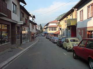
Brodarevo is a village in the municipality of Prijepolje, Serbia. According to the 2002 census, the village has a population of 6,500.
Babayevo is the name of several inhabited localities in Russia.
Krasnaya Rechka is the name of several rural localities in Russia: