Greenland is a North American autonomous territory of the Kingdom of Denmark. It is the largest country within the Kingdom and one of three countries which form the Kingdom, the others being Denmark proper and the Faroe Islands; the citizens of all three countries are citizens of Denmark. As Greenland is one of the Overseas Countries and Territories of the European Union, citizens of Greenland are also granted European Union citizenship. The capital and largest city of Greenland is Nuuk. Greenland lies between the Arctic and Atlantic oceans, east of the Canadian Arctic Archipelago. It is the world's largest island, as well as the northernmost area of the world – Kaffeklubben Island off the northern coast is the world's northernmost undisputed point of land, and Cape Morris Jesup on the mainland was thought to be so until the 1960s.

A phantom island is a purported island which was included on maps for a period of time, but was later found not to exist. They usually originate from the reports of early sailors exploring new regions, and are commonly the result of navigational errors, mistaken observations, unverified misinformation, or deliberate fabrication. Some have remained on maps for centuries before being "un-discovered."

Vinland, Vineland, or Winland was an area of coastal North America explored by Vikings. Leif Eriksson landed there around 1000 AD, nearly five centuries before the voyages of Christopher Columbus and John Cabot. The name appears in the Vinland Sagas, and describes Newfoundland and the Gulf of Saint Lawrence as far as northeastern New Brunswick. Much of the geographical content of the sagas corresponds to present-day knowledge of transatlantic travel and North America.

Ilulissat, formerly Jakobshavn or Jacobshaven, is the municipal seat and largest town of the Avannaata municipality in western Greenland, located approximately 350 km (220 mi) north of the Arctic Circle. With the population of 4,670 as of 2020, it is the third-largest city in Greenland, after Nuuk and Sisimiut. The city is home to almost as many sled-dogs as people.

The Norse exploration of North America began in the late 10th century, when Norsemen explored areas of the North Atlantic colonizing Greenland and creating a short term settlement near the northern tip of Newfoundland. This is known now as L'Anse aux Meadows where the remains of buildings were found in 1960 dating to approximately 1,000 years ago. This discovery helped reignite archaeological exploration for the Norse in the North Atlantic. This single settlement, located on the island of Newfoundland and not on the North American mainland, was abruptly abandoned.

Hans Poulsen Egede was a Dano-Norwegian Lutheran missionary who launched mission efforts to Greenland, which led him to be styled the Apostle of Greenland. He established a successful mission among the Inuit and is credited with revitalizing Dano-Norwegian interest in the island after contact had been broken for about 300 years. He founded Greenland's capital Godthåb, now known as Nuuk.

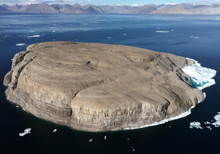
Hans Island is an island in the very centre of the Kennedy Channel of Nares Strait in the high Arctic region, split between the Canadian territory of Nunavut and the Danish autonomous country of Greenland. The island itself is barren and uninhabited with an area of 130 hectares, measuring 1,290 by 1,199 metres, and a maximum elevation of 168.17 m (551.7 ft). Its location in the strait that separates Ellesmere Island of Canada from northern Greenland was for years a border dispute, the so-called Whisky War between the two countries of Canada and Denmark. Hans Island is the smallest of three islands in Kennedy Channel off the Washington Land coast; the others are Franklin Island and Crozier Island. The strait at this point is 35 km (22 mi) wide, placing the island within the territorial waters of both Canada and Denmark (Greenland). A 1,280-metre-long (4,200 ft) border traverses the island.

Markland is the name given to one of three lands on North America's Atlantic shore discovered by Leif Eriksson around 1000 AD. It was located south of Helluland and north of Vinland.

The Zeno brothers, Nicolò and Antonio, were Italian noblemen from the Republic of Venice who lived during the 14th century. They came to prominence in 1558, when their descendant, Nicolò Zeno the Younger, published a map and a series of letters purporting to describe an exploration made by the brothers of the north Atlantic and Arctic waters in the 1390s. The younger Nicolò claimed the documents were discovered in a storeroom of his family home.

The Times Atlas of the World, rebranded The Times Atlas of the World: Comprehensive Edition in its 11th edition and The Times Comprehensive Atlas of the World from its 12th edition, is a world atlas currently published by HarperCollins Publisher L.L.C. Its most recent edition, the fifteenth, was published on 6 September 2018.

The Greenland national football team represents Greenland in non-FIFA international tournaments. It is controlled by the Football Association of Greenland. Although it has the same status as the Faroe Islands within the Kingdom of Denmark, Greenland is not, unlike the Faroe Islands national football team, a member of FIFA nor of any continental confederation and therefore is not eligible to enter the World Cup or other sanctioned tournaments. Most of the matches they have played have been against the Faroe Islands and Iceland, but neither of the two consider those games full internationals. In May 2022 it was announced that Greenland had officially applied to become a member of CONCACAF.

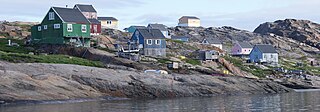
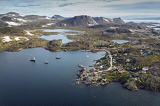
Tasiusaq is an island settlement in the Avannaata municipality in northwestern Greenland. It had 252 inhabitants in 2020. In Kalaallisut, the name means "looks like a lake".

Kullorsuaq is a settlement in the Avannaata municipality in northwestern Greenland. It is the northernmost settlement in the Upernavik Archipelago, located on Kullorsuaq Island at the southern end of Melville Bay, itself part of the larger Baffin Bay.

Nuussuaq, formerly Kraulshavn, is a settlement in Avannaata municipality in northwestern Greenland. It is the only mainland settlement in the Upernavik Archipelago, located near the western tip of the Nuussuaq Peninsula, on the northern coast of Sugar Loaf Bay, an indentation of Baffin Bay.

Oqaatsut, formerly Rodebay or Rodebaai, is a settlement in Avannaata municipality, in western Greenland. It had 29 inhabitants in 2020. The modern name of the settlement is Kalaallisut for "Cormorants". The village is served by the communal all-purpose Pilersuisoq store.
Innaarsuit is an island settlement in Avannaata municipality in northwestern Greenland. Located on an island of the same name, the settlement had 180 inhabitants in 2020.

Kulusuk, formerly Kap Dan, is a settlement in the Sermersooq municipality in southeastern Greenland, located on an island of the same name. The settlement population of 241 includes many Danes choosing to live there due to the airport. In the Kalaallisut language, the name of the village means "Chest of a Black Guillemot".
This page is a historical timeline of the island known as Greenland or Kalaallit Nunaat.

King Frederick VIII Land is a major geographic division of northeastern Greenland. It extends above the Arctic Circle from 76°N to 81°N in a North-South direction along the coast of the Greenland Sea.

The Denmark expedition, also known as the Denmark Expedition to Greenland's Northeast Coast and the Danmark Expedition after the ship's name, was an expedition to northeastern Greenland in 1906–1908.


