Related Research Articles

The Gdańsk Voivodeship was a voivodeship (province) of the Polish People's Republic from 1975 to 1989, and the Third Republic of Poland from 1989 to 1998. Its capital was Gdańsk, and it was centered on the region of Pomerelia. It was established on 1 June 1975, from the parts of the voivodeships of Gdańsk, and Bydgoszcz, and existed until 31 December 1998, when it was incorporated into then-established Pomeranian Voivodeship.

A sołtys is a head of a sołectwo elected by its permanent citizens in a village meeting. According to data from 2010, Poland had 40 thousand sołtys, 30.7% of which were women.
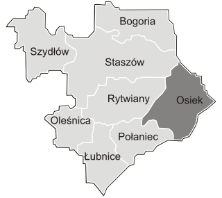
Gmina Osiek is an urban-rural gmina in Staszów County, Świętokrzyskie Voivodeship, in south-central Poland. Its seat is the town of Osiek, which lies approximately 21 kilometres (13 mi) east of Staszów and 71 km (44 mi) south-east of the regional capital Kielce.

Białystok Voivodeship was a unit of administrative division and local government in Poland from 1944 to 1975, when its purview was separated into eastern Suwałki Voivodeship, Łomża Voivodeship and Białystok Voivodeship (1975–1998). Its capital city was Białystok. The establishment of Podlaskie Voivodeship in 1999 was essentially a reunion of the areas of Białystok Voivodeship (1945–1975).
Bukowa is a village in the administrative district of Gmina Osiek, within Staszów County, Świętokrzyskie Voivodeship, in south-central Poland. It lies approximately 7 kilometres (4 mi) north of Osiek, 19 km (12 mi) east of Staszów, and 67 km (42 mi) south-east of the regional capital Kielce.

Długołęka is a village in the administrative district of Gmina Osiek, within Staszów County, Świętokrzyskie Voivodeship, in south-central Poland. It lies approximately 4 kilometres (2 mi) east of Osiek, 24 km (15 mi) east of Staszów, and 75 km (47 mi) south-east of the regional capital Kielce.
Lipnik is a village in the administrative district of Gmina Osiek, within Staszów County, Świętokrzyskie Voivodeship, in south-central Poland. It lies approximately 4 kilometres (2 mi) south-east of Osiek, 23 km (14 mi) east of Staszów, and 75 km (47 mi) south-east of the regional capital Kielce.
Mikołajów is a village in the administrative district of Gmina Osiek, within Staszów County, Świętokrzyskie Voivodeship, in south-central Poland. It lies approximately 3 kilometres (2 mi) south of Osiek, 20 km (12 mi) east of Staszów, and 72 km (45 mi) south-east of the regional capital Kielce.
Mucharzew is a village in the administrative district of Gmina Osiek, within Staszów County, Świętokrzyskie Voivodeship, in south-central Poland. It lies approximately 7 kilometres (4 mi) west of Osiek, 15 km (9 mi) south-east of Staszów, and 67 km (42 mi) south-east of the regional capital Kielce.
Ossala is a village in the administrative district of Gmina Osiek, within Staszów County, Świętokrzyskie Voivodeship, in southern Poland. It lies approximately 7 kilometres (4 mi) south-west of Osiek, 17 km (11 mi) south-east of Staszów, and 69 km (43 mi) south-east of the regional capital Kielce.
Ossala-Lesisko is a village in the administrative district of Gmina Osiek, within Staszów County, Świętokrzyskie Voivodeship, in south-central Poland. It lies approximately 9 kilometres (6 mi) west of Osiek, 14 km (9 mi) south-east of Staszów, and 67 km (42 mi) south-east of the regional capital Kielce.
Strużki is a village in the administrative district of Gmina Osiek, within Staszów County, Świętokrzyskie Voivodeship, in south-central Poland. It lies approximately 8 kilometres (5 mi) south-west of Osiek, 17 km (11 mi) south-east of Staszów, and 70 km (43 mi) south-east of the regional capital Kielce.
Suchowola is a village in the administrative district of Gmina Osiek, within Staszów County, Świętokrzyskie Voivodeship, in south-central Poland. It lies approximately 4 kilometres (2 mi) north-west of Osiek, 18 km (11 mi) east of Staszów, and 68 km (42 mi) south-east of the regional capital Kielce.
Trzcianka-Kolonia is a colony in the administrative district of Gmina Osiek, within Staszów County, Świętokrzyskie Voivodeship, in south-central Poland. It lies approximately 6 kilometres (4 mi) south-west of Osiek, 20 km (12 mi) south-east of Staszów, and 72 km (45 mi) south-east of the regional capital Kielce.
Gromada Tursko Wielkie is a group consisting of several villages, constituted the lowest tier of local government, taking over the role previously played by gmina Tursko Wielkie; at a smaller scale. In communist Poland between 29 September 1954 and 31 December 1972, this assembly was introduced. Gromada was the lowest administrative division of Poland.
The Szczecin Voivodeship was a voivodeship (province) with its capital in Szczecin, that was centered on the Farther Pomerania. It existed from 1946 to 1975. Until 19 February 1947 it was under the administration of Provisional Government of National Unity, which then was replaced by the Polish People's Republic. It was established on 28 June 1946, when it was carved out of the territory of the District of the Western Pomerania, and parts of the Gdańsk, and Pomeranian Voivodeships. On 6 July 1950, its eastern half was incorporated into then-established Koszalin Voivodeship, and the voivodeship ceased to exist on 31 May 1975, when it was replaced by then-established Szczecin and Gorzów Voivodeships.

The Kalisz Voivodeship was a voivodeship (province) of the Polish People's Republic from 1975 to 1989, and the Republic of Poland from 1989 to 1998. Its capital was Kalisz, and it was centred on the Kalisz Region. It was established on 1 June 1975, from the parts of the Poznań, Wrocław, and Łódź Voivodeships, and existed until 31 December 1998, when it was partitioned between then-established Greater Poland, Lower Silesian, and Łódź Voivodeships.

The Kraków Voivodeship, from 1975 to 1984 known as the Kraków Metropolitan Voivodeship, was a voivodeship (province) of the Polish People's Republic from 1975 to 1989, and the Republic of Poland from 1989 to 1998. Its territory included its capital, Kraków and the surrounding municipalities. It was established on 1 June 1975 from the part of the Kraków Voivodeship, and the city of Kraków, which until then acted as a separate administrative division. It existed until 31 December 1998, when it got incorporated into then-established Lesser Poland Voivodeship.

The Koszalin Voivodeship was a voivodeship (province) of the Polish People's Republic, with capital in Koszalin, that existed from 1950 to 1975. It was established on 6 July 1950, from the eastern half of the Szczecin Voivodeship, and existed until 31 May 1975, when it was partitioned between then-established voivodeships of Koszalin, Słupsk, and Piła.

The Koszalin Voivodeship was a voivodeship (province) of the Polish People's Republic from 1975 to 1989, and the Third Republic of Poland from 1989 to 1998. Its capital was Koszalin, and it was centered on the eastern Farther Pomerania. It was established on 1 June 1975, from the part of the Koszalin Voivodeship, and existed until 31 December 1998, when it was incorporated into then-established West Pomeranian Voivodeship.
References
- ↑ "Dz.U. 1954 nr 43 poz. 191" [Journal of the Laws of 1954, No. 43, item 191]. Ustawa z dnia 25 września 1954 r. o reformie podziału administracyjnego wsi i powołaniu gromadzkich rad narodowych[Act of September 25, 1954 on the reform of administrative division and the establishment of village and the constituent Gromadzka National Councils] (in Polish). They signed under this act: Zawadzki, Aleksander — President of Council of State of the Republic of Poland; Rybicki, Marian — Secretary Council of State. Warsaw, Poland: Lower house of the Polish parliament. 25 September 1954. pp. 349–353.
{{cite book}}: CS1 maint: others (link) - ↑ "Dz.U. 1972 nr 49 poz. 312" [Journal of the Laws of 1972, No. 49, item 312]. Ustawa z dnia 29 listopada 1972 r. o utworzeniu gmin i zmianie ustawy o radach narodowych[Act of November 29, 1972 on the establishment of gminas and amending the law on National Councils] (in Polish). They signed under this act: Jabłoński, Henryk — President of Council of State of the Republic of Poland; Stasiak, Ludomir — Secretary Council of State. Warsaw, Poland: Lower house of the Polish parliament. 29 November 1972. pp. 474–480. Archived from the original on 26 January 2013. Retrieved 17 January 2012.
{{cite book}}: CS1 maint: others (link) - 1 2 Cf. Kaczmarek, Leon (ed.); Taszycki, Witold (1970). Urzędowe nazwy miejscowości i obiektów fizjograficznych. 33. Powiat staszowski województwo kieleckie[Official Names of Localities and Physiographic Objects. 33. Staszów County Kielce Voivodeship] (in Polish). Commission for Establishing Names of Localities and Physiographic Objects (to business use). Vol. 33. Warsaw, Poland: Council of Ministers' Office. Cabinet Office for bureaux of the Supervisory Boards. pp. 28–33, 77–96.
{{cite book}}:|first1=has generic name (help) - ↑ Cf. Wykaz Gromad Polskiej Rzeczypospolitej Ludowej według stanu z dnia 1 VII 1952 r.[List of Gromadas of the Polish People’s Republic according to of July 1, 1952] (in Polish). Warsaw: Polish People’s Republic. Central Statistical Office. 1952.