Related Research Articles

A powiat is the second-level unit of local government and administration in Poland, equivalent to a county, district or prefecture in other countries. The term "powiat" is most often translated into English as "county" or "district". In historical contexts, this may be confusing because the Polish term hrabstwo (an administrative unit administered/owned by a hrabia is also literally translated as "county".

Białystok Voivodeship was a unit of administrative division and local government in Poland from 1975 to 1998, when it was superseded by the Podlaskie Voivodeship. Its capital city was Białystok. It was formed in 1975 from part of the existing Białystok Voivodeship. The region was 10,055 km2 (3,882 sq mi), and its population in 1994, about 700 000 inhabitants. It was divided into 20 cities and 50 municipalities. It bordered with four Voivodeships: Suwałki, Łomża, Siedlce and Biała Podlaska and until 1991 with the Soviet Union, and later with Belarus.

Kościerzyna County is a unit of territorial administration and local government (powiat) in Pomeranian Voivodeship, northern Poland. It came into being on 1 January 1999 as a result of the Polish local government reforms passed in 1998. Its administrative seat and only town is Kościerzyna, which lies 51 kilometres (32 mi) south-west of the regional capital Gdańsk. Its borders equal approximately the borders of the old Marquessate of Berent in the German Empire.
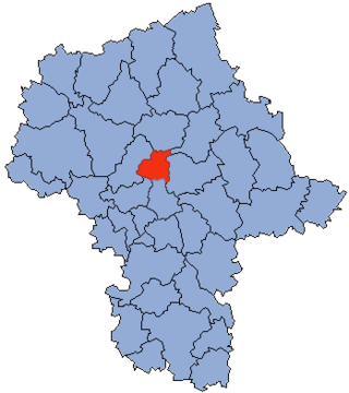
Legionowo County is a unit of territorial administration and local government (powiat) in Masovian Voivodeship, east-central Poland. It came into being on 1 January 1999 as a result of the Polish local government reforms passed in 1998. Its administrative seat and largest town is Legionowo, which lies 22 kilometres (14 mi) north of Warsaw. The only other town in the county is Serock, lying 17 km (11 mi) north-east of Legionowo.
A wójt is the highest administrative officer of a Polish rural gmina, i.e., of a commune (gmina) comprising only villages.

The gmina is the basic unit of the administrative division of Poland, similar to a municipality. As of 1 January 2019, there were 2,477 gminy throughout the country, encompassing over 43,000 villages. Nine hundred and forty gminy include cities and towns, with 302 among them constituting an independent urban gmina consisting solely of a standalone town or one of the 107 cities, the latter governed by a city mayor.

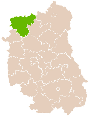
Lublin County is a unit of territorial administration and local government (powiat) in Lublin Voivodeship, eastern Poland. It was established on January 1, 1999, as a result of the Polish local government reforms passed in 1998. Its administrative seat is the city of Lublin, although the city is not part of the county. The only towns in Lublin County are Bełżyce, which lies 23 km (14 mi) west of Lublin, and Bychawa, 26 km (16 mi) south of Lublin.
Łuków County is a unit of territorial administration and local government (powiat) in Lublin Voivodeship, eastern Poland. It was established on January 1, 1999, as a result of the Polish local government reforms passed in 1998. Its administrative seat and largest town is Łuków, which lies 76 kilometres (47 mi) north of the regional capital Lublin. The only other town in the county is Stoczek Łukowski, lying 30 km (19 mi) west of Łuków.
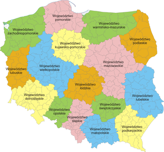
The administrative division of Poland since 1999 has been based on three levels of subdivision. The territory of Poland is divided into voivodeships (provinces); these are further divided into powiats, and these in turn are divided into gminas. Major cities normally have the status of both gmina and powiat. Poland currently has 16 voivodeships, 380 powiats, and 2,478 gminas.

A sołtys is a head of a sołectwo elected by its permanent citizens in a village meeting. According to data from 2010, Poland had 40 thousand sołtys, 30.7% of which were women.
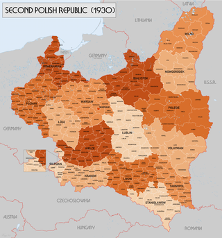
Subdivisions of the Second Polish Republic became an issue immediately after the creation of the Second Polish Republic in 1918. The Polish–Lithuanian Commonwealth had been partitioned in the late 18th century. The various parts of what was now Polish territory had belonged to different states with different administrative structures: Austria-Hungary, the German Empire and the Russian Empire.
Augustówka is a neighbourhood, and an area of the City Information System, in the city of Warsaw, Poland, located within the district of Mokotów.
Gromada is a village in the administrative district of Gmina Biłgoraj, within Biłgoraj County, Lublin Voivodeship, in eastern Poland. It lies approximately 3 kilometres (2 mi) north-west of Biłgoraj and 77 km (48 mi) south of the regional capital Lublin. Gromada is situated within the Central European Summer Time timezone.

Białystok Voivodeship was a unit of administrative division and local government in Poland from 1944 to 1975, when its purview was separated into eastern Suwałki Voivodeship, Łomża Voivodeship and Białystok Voivodeship (1975–1998). Its capital city was Białystok. The establishment of Podlaskie Voivodeship in 1999 was essentially a reunion of the areas of Białystok Voivodeship (1945–1975).
Gromada is a village in the administrative district of Gmina Tarnawatka, within Tomaszów Lubelski County, Lublin Voivodeship, in eastern Poland.

Bortnytsia is a village in Rivne oblast, near the town of Dubno, in Dubno Raion, Ukraine. The village currently has a population of 365.
Zbiersk-Cukrownia is a village in the administrative district of Gmina Stawiszyn, within Kalisz County, Greater Poland Voivodeship, in west-central Poland. It lies approximately 5 kilometres (3 mi) north-east of Stawiszyn, 22 km (14 mi) north of Kalisz, and 98 km (61 mi) south-east of the regional capital Poznań.
Gromada Tursko Wielkie is a group consisting of several villages, constituted the lowest tier of local government, taking over the role previously played by gmina Tursko Wielkie; at a smaller scale. In communist Poland between 29 September 1954 and 31 December 1972, this assembly was introduced. Gromada was the lowest administrative division of Poland.
Gromada Osiek is a group of several Polish villages, constituted at the lowest tier of local government. They take over the role previously played by Gmina Osiek at a smaller scale than Gmina Osiek. In communist Poland between September 29, 1954 to December 31, 1972 these villages were introduced as a Polish word meaning “Osiek”. These units are created by the Communist Polish Law and have legal effect.
References
- 1 2 3 Roczniak, Władysław (2004). "The Polish "gromada" peasant collectives in the era of re-feudalization" . The Polish Review. 49 (4). University of Illinois Press: 1083–1101.
| | This Poland-related article is a stub. You can help Wikipedia by expanding it. |