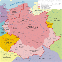
Administrative divisions of Poland

Last updated

The administrative division of Poland since 1999 has been based on three levels of subdivision. The territory of Poland is divided into voivodeships (provinces); these are further divided into powiats (counties or districts), and these in turn are divided into gminas (communes or municipalities). Major cities normally have the status of both gmina and powiat. Poland currently has 16 voivodeships, 380 powiats (including 66 cities with powiat status), and 2,478 gminas. [1]

Contents

The current system was introduced pursuant to a series of acts passed by the Polish parliament in 1998, and came into effect on 1 January 1999. Between 1975 and 1998 there had been 49 smaller "voivodeships" and no powiats (see subdivisions of the Polish People's Republic). The reform created 16 larger voivodeships (largely based on and named after historical regions) and reintroduced powiats.

The boundaries of the voivodeships do not always reflect the historical borders of Polish regions. Around half of the Silesian Voivodeship belongs to the historical province of Lesser Poland. Similarly, the area around Radom, which historically is part of Lesser Poland, is located in the Masovian Voivodeship. Also, the Pomeranian Voivodeship includes only the eastern extreme of historical Pomerania, as the western part is in Germany and the eastern border has shifted again and again.

Division of Poland into voivodeships and powiats (2007) POLSKA mapa woj z powiatami.png
Division of Poland into voivodeships and powiats (2007)

Voivodeships

Poland is currently divided into 16 provinces known as voivodeships (Polish : województwa, singular województwo). Legally they are called "I tier units" (jednostki I stopnia). Administrative authority at voivodeship level is shared between a central government-appointed governor, called the voivode (usually a political appointee), an elected assembly called the sejmik, and an executive board (zarząd województwa) chosen by that assembly. The leader of that executive is called the marszałek .

#FlagEmblemVoivodeshipPolish nameCapital city (cities)
1
POL wojewodztwo wielkopolskie flag.svg
POL wojewodztwo wielkopolskie COA.svg
Greater Poland wielkopolskie Poznań
2
POL wojewodztwo kujawsko-pomorskie flag.svg
POL wojewodztwo kujawsko-pomorskie COA.svg
Kuyavia-Pomerania kujawsko-pomorskie Bydgoszcz and Toruń
3
POL wojewodztwo malopolskie flag.svg
POL wojewodztwo malopolskie COA.svg
Lesser Poland małopolskie Kraków
4
POL wojewodztwo lodzkie 1 flag.svg
POL wojewodztwo lodzkie COA.svg
Łódź łódzkie Łódź
5
POL wojewodztwo dolnoslaskie flag.svg
POL wojewodztwo dolnoslaskie COA.svg
Lower Silesia dolnośląskie Wrocław
6
POL wojewodztwo lubelskie flag.svg
POL wojewodztwo lubelskie COA.svg
Lublin lubelskie Lublin
7
POL wojewodztwo lubuskie flag.svg
POL wojewodztwo lubuskie COA.svg
Lubusz lubuskie Gorzów Wielkopolski and Zielona Góra
8
POL wojewodztwo mazowieckie flag.svg
POL wojewodztwo mazowieckie COA.svg
Masovia mazowieckie Warsaw
9
POL wojewodztwo opolskie flag.svg
POL wojewodztwo opolskie COA.svg
Opole opolskie Opole
10
POL wojewodztwo podlaskie flag.svg
POL wojewodztwo podlaskie COA.svg
Podlaskie podlaskie Białystok
11
POL wojewodztwo pomorskie flag.svg
POL wojewodztwo pomorskie COA.svg
Pomerania pomorskie Gdańsk
12
POL wojewodztwo slaskie flag.svg
POL wojewodztwo slaskie COA.svg
Silesia śląskie Katowice
13
POL wojewodztwo podkarpackie flag.svg
POL wojewodztwo podkarpackie COA.svg
Subcarpathia podkarpackie Rzeszów
14
POL wojewodztwo swietokrzyskie flag.svg
POL wojewodztwo swietokrzyskie COA.svg
Świętokrzyskie świętokrzyskie Kielce
15
POL wojewodztwo warminsko-mazurskie flag.svg
POL wojewodztwo warminsko-mazurskie COA.svg
Warmia-Masuria warmińsko-mazurskie Olsztyn
16
POL wojewodztwo zachodniopomorskie flag.svg
POL wojewodztwo zachodniopomorskie COA.svg
West Pomerania zachodniopomorskie Szczecin

Powiats

Each voivodeship is divided into a number of smaller entities known as powiats (counties), which are legally "II tier units" (jednostki II stopnia). The number of powiats per voivodeship ranges from 12 (Opole Voivodeship) to 42 (Masovian Voivodeship). They include two types of administrative divisions:

Tier units of the administrative division in Poland. Administrative-division-of-Poland.webp
Tier units of the administrative division in Poland.

Gminas

The "III tier units" (jednostki III stopnia) are 2477 gminas (also called commune or municipality). A powiat is typically divided into a number of gminas (between 3 and 19), although the city counties constitute single gminas. A gmina has an elected council as well as a directly elected mayor (known as prezydent in large towns, burmistrz in most urban and urban-rural gminas, and wójt in rural gminas). A gmina may be classed as:

Smaller units

Gminas are generally sub-divided into smaller units, called osiedle or dzielnica in towns, and sołectwo in rural areas. However, these units are of lesser importance and are subordinate in status to the gmina.

Historical subdivisions

Polish territory has been subject to significant changes over the course of Polish history. Therefore, the modern Polish administrative division, while on some levels similar to some historical ones, is quite different from others. Historical Polish administrative divisions can be divided into the following periods:

See also

Cultural and economic:

Similar administrative division:

Related Research Articles

<span class="mw-page-title-main">Pomerania</span> Historical region on the southern shore of the Baltic Sea in Central Europe

Pomerania is a historical region on the southern shore of the Baltic Sea in Central Europe, split between Poland and Germany. The central and eastern part belongs to the West Pomeranian, Pomeranian and Kuyavian-Pomeranian voivodeships of Poland, while the western part belongs to the German states of Mecklenburg-Western Pomerania and Brandenburg.

A county is a geographic region of a country used for administrative or other purposes in some nations. The term is derived from the Old French comté denoting a jurisdiction under the sovereignty of a count (earl) or a viscount. Literal equivalents in other languages, derived from the equivalent of "count", are now seldom used officially, including comté, contea, contado, comtat, condado, Grafschaft, graafschap, and zhupa in Slavic languages; terms equivalent to 'commune' or 'community' are now often instead used.

<span class="mw-page-title-main">Voivodeships of Poland</span> Highest-level administrative division of Poland

A voivodeship is the highest-level administrative division of Poland, corresponding to a province in many other countries. The term has been in use since the 14th century and is commonly translated into English as "province".

<span class="mw-page-title-main">Powiat</span> Provincial unit in Poland

A powiat is the second-level unit of local government and administration in Poland, equivalent to a county, district or prefecture in other countries. The term "powiat" is most often translated into English as "county" or "district". In historical contexts, this may be confusing because the Polish term hrabstwo (an administrative unit administered/owned by a hrabia is also literally translated as "county".

<span class="mw-page-title-main">Białystok Voivodeship (1975–1998)</span>

Białystok Voivodeship was a unit of administrative division and local government in Poland from 1975 to 1998, when it was superseded by the Podlaskie Voivodeship. Its capital city was Białystok. It was formed in 1975 from part of the existing Białystok Voivodeship. The region was 10,055 km2 (3,882 sq mi), and its population in 1994, about 700 000 inhabitants. It was divided into 20 cities and 50 municipalities. It bordered with four Voivodeships: Suwałki, Łomża, Siedlce and Biała Podlaska and until 1991 with the Soviet Union, and later with Belarus.

<span class="mw-page-title-main">Karkonosze County</span> County in Lower Silesian Voivodeship, Poland

Karkonosze County is a unit of territorial administration and local government (powiat) in Lower Silesian Voivodeship, south-western Poland. It came into being on January 1, 1999, as a result of the Polish local government reforms passed in 1998.

<span class="mw-page-title-main">Kreis Wirsitz</span>

Kreis Wirsitz was one of 14 or 15 Kreise in the northern administrative district of Bromberg, in the Prussian province of Posen. The county existed with essentially the same boundaries beginning in 1815 as a German Kreise then from 1919 as a Polish Powiat until 1975. Its administrative center was the town of Wyrzysk (Wirsitz). The county contained additional municipalities such as Bialosliwie, Lobzenica (Lobsens), Miasteczko Krajeńskie (Friedheim), Mrocza (Mrotschen), Nakło nad Notecią (Nakel), Sadki and Wysoka (Wissek) plus over 100 villages. Many villages that had Germanic names were changed to completely different Polish names following World War II, such as Radzicz. In 1954 the central government abolished the commune as the smallest unit of government, dividing the county into 28 clusters. In 1973 municipalities were restored. After the administrative reform of 1975, the territory of the county was divided between the new (lower) region of Bydgoszcz and the region Piła. The territory of the defunct county was annexed by Naklo County, Kujavian-Pomeranian Voivodeship and Pila County, Greater Poland Voivodeship. Wyrzysk was incorporated into Piła County.

<span class="mw-page-title-main">Puck County</span> County in Pomeranian Voivodeship, Poland

Puck County is a unit of territorial administration and local government (powiat) in Pomeranian Voivodeship, northern Poland, on the Baltic coast. The powiat of this name existed in the history of Poland, since the times of the Polish–Lithuanian Commonwealth up to 1795, and then reintroduced in 1999.

<span class="mw-page-title-main">Gmina</span> Municipal-level administrative division of Poland

The gmina is the basic unit of the administrative division of Poland, similar to a municipality. As of 1 January 2019, there were 2,477 gminy throughout the country, encompassing over 43,000 villages. Nine hundred and forty gminy include cities and towns, with 302 among them constituting an independent urban gmina consisting solely of a standalone town or one of the 107 cities, the latter governed by a city mayor.

<span class="mw-page-title-main">Suwałki Region</span> Historical region in Poland

Suwałki Region is a small region around the city of Suwałki in northeastern Poland near the border with Lithuania. It encompasses the powiats of Augustów, Suwałki, and Sejny, and roughly corresponds to the southern part of the former Suwałki Governorate.

<span class="mw-page-title-main">Subdivisions of the Polish–Lithuanian Commonwealth</span>

Subdivisions of the Polish–Lithuanian Commonwealth evolved over for centuries of its existence from the signing of the Union of Lublin to the third partition.

<span class="mw-page-title-main">Cieszyn County</span> County in Silesian Voivodeship, Poland

Cieszyn County is a unit of territorial administration and local government (powiat) in Silesian Voivodeship, southern Poland, on the Czech and Slovak border. It came into being on January 1, 1999, as a result of the Polish local government reforms passed in 1998.

<span class="mw-page-title-main">Nowy Sącz County</span> County in Lesser Poland Voivodeship, Poland

Nowy Sącz County is a unit of territorial administration and local government (powiat) in Lesser Poland Voivodeship, southern Poland, on the Slovak border. It came into being on January 1, 1999, as a result of the Polish local government reforms passed in 1998. Its administrative seat is the city of Nowy Sącz, although the city is not part of the county. The county contains five towns: Krynica-Zdrój, 31 km (19 mi) south-east of Nowy Sącz, Stary Sącz, 9 km (6 mi) south-west of Nowy Sącz, Grybów, 19 km (12 mi) east of Nowy Sącz, Piwniczna-Zdrój, 21 km (13 mi) south of Nowy Sącz, and Muszyna, 33 km (21 mi) south-east of Nowy Sącz.

<span class="mw-page-title-main">Łuków County</span> County in Lublin Voivodeship, Poland

Łuków County is a unit of territorial administration and local government (powiat) in Lublin Voivodeship, eastern Poland. It was established on January 1, 1999, as a result of the Polish local government reforms passed in 1998. Its administrative seat and largest town is Łuków, which lies 76 kilometres (47 mi) north of the regional capital Lublin. The only other town in the county is Stoczek Łukowski, lying 30 km (19 mi) west of Łuków.

<span class="mw-page-title-main">Subdivisions of Congress Poland</span>

Congress Poland was subdivided several times from its creation in 1815 until its dissolution in 1918. Congress Poland was divided into departments, a relic from the times of the French-dominated Duchy of Warsaw. In 1816 the administrative divisions were changed to forms that were more traditionally Polish: voivodeships, obwóds and powiats. Following the November Uprising, the subdivisions were again changed in 1837 to bring the subdivisions closer to the structure of the Russian Empire when guberniyas (governorates) were introduced. In this way, Congress Poland was gradually transformed into the "Vistulan Country". Over the next several decades, various smaller reforms were carried out, either changing the smaller administrative units or merging/splitting various guberniyas.

<span class="mw-page-title-main">Subdivisions of the Second Polish Republic</span>

Subdivisions of the Second Polish Republic became an issue immediately after the creation of the Second Polish Republic in 1918. The Polish–Lithuanian Commonwealth had been partitioned in the late 18th century. The various parts of what was now Polish territory had belonged to different states with different administrative structures: Austria-Hungary, the German Empire and the Russian Empire.

A city with powiat rights is in Poland a designation denoting 66 of the 107 cities which exercise also the powers and duties of a county, thus being an independent city. They have roughly the same status as former county boroughs in the United Kingdom.

References

  1. "Population. Size and structure and vital statistics in Poland by territorial division in 2017. As of December, 31" (PDF) (in Polish). Główny Urząd Statystyczny (Central Statistical Office). Retrieved 27 June 2018.
  2. www.ideo.pl, ideo- (2019-04-27). "Gminy wiejskie chcą lepszej ochrony swych granic". Prawo.pl (in Polish). Retrieved 2021-02-15.