Subdivisions of the Kingdom of Galicia and Lodomeria
Last updated
This article contains numerous links to pages on foreign language Wikipedias. They are shown as red links with the language codes in [small blue letters] in brackets. Click on the language code to see the page in that language.
Prior to 1867, while a crown land of the Austrian Empire and before that as part of the Habsburg monarchy, the kingdom had instead been divided into Kreise since the late 18th century, which from 1854 were subdivided into Bezirke (referred to as Amtsbezirke[de] ('office districts'), to distinguish them from other types of Bezirk).
The Kingdom of Galicia and Lodomeria was the largest and most populous crown land of Cisleithania (i.e. the non-Hungarian parts of the Habsburg realms) between 1772 and 1918. More widely, the central European region of Galicia is today split between the modern states of Poland and Ukraine. Despite having passed through several intermediate states during the great wars of the 20th century, the regions have mainly preserved their territorial integrity and continue to demarcate the jurisdiction of local government authorities in their successor states.
Kreise (until 1865)
A map showing the Kreise and Kreisdistrikte of Galicia and Lodomeria 1777–82
The Kreise (lit.'circles'; sg.Kreis; Polish: cyrkuły, sg.cyrkuł; Ukrainian: округиokruhy, sg.округokruh) of Galicia and Lodomeria go back in some form to the aftermath of the First Partition of Poland in 1772 which led to the Kingdom's creation, but did not take something resembling their final form until 1782. They were (generally) named after their capital/seat; usually this would take the form [genitival adjectival form of the name]Kreis (usually simply [Name]erKreis e.g. Lemberger Kreis from Lemberg, the German name for Lviv), but Kreis[standard form of the name] (e.g. Kreis Lemberg) was also used, especially later, and the two forms were interchangeable.
At first, Galicia and Lodomeria was divided into 6 large Kreise, which were subdivided into 59 Kreisdistrikte ('circle districts') in 1773. In 1775 the number of Kreisdistrikte was reduced to 19.
The 18 Kreise of Galicia and Lodomeria c.1782.
In 1782 the two-level system was abolished and Galicia and Lodomeria was divided into 18 Kreise of the type used in the other non-Hungarian Habsburg realms (what would later be called Cisleithania). Over the next decade these would mostly take the forms which would persist until the mid-19th century.
As the border of Galicia and Lodomeria itself, the Vistula formed the northern borders of the Myslenicer, Bochnier, Tarnower and (partially) Rzeszower Kreise.
The Bukowiner Kreis (an exception where the name derives from the region, although it was also known as Czernowitzer Kreis) was added to Galicia and Lodomeria in 1786, having previously been a separate military district.
In 1791 the Dukler Kreis had become the Jasłoer Kreis when its capital moved there.
The lands gained by the Habsburgs in the 1795 Third Partition of Poland became West (or New) Galicia, a separate part of the kingdom. It too was divided into Kreise. The area around Krakau on the right (southern) bank of the Vistula was transferred to the Krakauer Kreis. West Galicia was incorporated into Galicia-proper in 1803 as a semi-autonomous region.
West Galicia was largely bounded by the Vistula, Bug and Pilica rivers. The Vistula also formed the eastern border of the Radomer Kreis, the western border of the Josefower and Wiazownaer Kreise, the eastern and southern border of the Opatower Kreis, the southern border of the Stopnicer Kreis and part of those of the Slomniker and Krakauer Kreise.
Sometimes the Myślenicer, Bochnier and Sandecer Kreise from the first partition were considered as a part of West Galicia.
Maps of the Kreise of West Galicia c.1803
In 1803 West and East Galicia were united into Galicia and the number of Kreise in West Galicia was reduced to 6: Krakuer, Kielcer, Radomer, Lubliner, Chełmer, Bialer.
In 1809 the Treaty of Schönbrunn ceded the third-partition-territory plus the Zamośćer Kreis[de; pl] and an area around Krakau on the right bank of the Vistula to the Duchy of Warsaw,[3] a Napoleonicclient. It also ceded the Tarnopoler Kreis and most of the Zalestschyker Kreis to the Russian Empire,[4] where they became the Tarnopolsky Krai[de; pl; ru; uk]. Most of the rump of Zalestschyker Kreis was merged with a part of the Stanislauer Kreis to become the Kolomeaer Kreis with the rest going to the Stanislauer Kreis itself.
The Tarnopolsky Krai was returned to Austria in 1815 (Congress of Vienna); the former Zalestschyker Kreis became the Czortkower Kreis. The area adjacent to Krakau on the right bank of the Vistula, which had been part of the Duchy of Warsaw, went to the Myslenicer and Bochnier Kreise, re-establishing the Vistula as the border. (The other territories which had been ceded to the Duchy of Warsaw on the other hand went to the Russian-controlled Congress Poland, other than the city of Kraków and its environs, which became the Free City of Cracow.)
In 1819 the Myslenicer Kreis became the Wadowicer Kreis.
The Free City of Cracow was annexed by Austria in 1846, nominally becoming the Grand Duchy of Kraków but administratively added to Galicia as the Krakauer Kreis. The extent of this Kreis, which matched that of the former free city, was similar but not identical to the earlier Krakauer Kreis of West Galicia.
In 1850, following the Revolutions of 1848 the Kreise were abolished and replaced with a system of political districts (see §Regierungsbezirke and political districts (1850–53)) but these changes were reversed in Bach's reforms from 1853.[6] The changes to Galicia and Lodomeria were specifically laid out in 1854: they divided the crown land into two Verwaltungsgebiete (administrative regions/territories) based in Lemberg (Lviv/Lwów) and Krakau (Krawów), which each oversaw some of the land's Kreise; the two cities themselves were directly subordinate to the crown land. The Kreise were also subdivided into Bezirke ('districts'; also referred to as Amtsbezirke[de] ('office districts')).[7]
In 1860 Verwaltungsgebiet Krakau and Bukovina were dissolved and re-subordinated to Lemberg; the Jasłoer Kreis was partitioned between the Sandecer, Tarnower, Rzeszower and Sanoker Kreise; the Wadowicer and Bochnier Kreise were merged into Kreis Krakau.[8] Bukovina was detached again in the 1861 February Patent.[9]
Below is a list of the divisions (Verwaltungsgebiete, Kreise and Bezirke) as of 1854,[7] with changes after that noted. (Divisions are listed with the names used in the legislation, i.e. mostly in contemporary German and/or Polish. Capitals are in bold.):
The Kreise in Galicia and Lodomeria were abolished in 1865 (enacted 23 September, effective 31 October), with the Bezirksämter subordinated directly to Lemberg.[11]
Regierungsbezirke and political districts (1850–53)
In 1850, in the aftermath of the revolutions of 1848, Galicia and Lodomeria was divided into three Regierungsbezirke ('government districts'), named after their capitals: Lemberg (Lviv/Lwów), Krakau (Kraków) and Stanislau (Stanislaviv/Stanisławów; today called Ivano-Frankivsk). The Kreise were abolished and replaced with political districts (Bezirkshauptmannschaften).[12] While political districts where also introduced in many other crown lands, they generally either retained their Kreise (often with a reduced number) or were not divided other than into political districts; the Regierungsbezirke were specific to Galicia and Lodomeria. This first attempt to introduce political districts to the Empire ended in 1853 with Bach's reforms.
Regierungsbezirk Krakau, the area from the Carpathians to the Vistula, and the San basin (i.e. the area west of the San basin). Comprised the former Kreise of Krakau, Wadowice, Bochnia, Sandec, Jasło, Tarnów and Rzeszow, along with parts of the Sanok and Przemyśl Kreise. It had 26 districts:
Krakau
Chrzanow
Podgórze
Kenty
Saybusch
Wadowice
Jordanow
Neumarkt
Dobczyce
Bochnia
Alt-Sandec
Neu-Sandec
Grybow
Gorlice
Jasło
Tarnow
Dombrowa
Sędziszow
Pilsno
Mielec
Dukla
Krosno
Rzeszow
Łańcut
Rozwadow
Przeworsk
Regierungsbezirk Lemberg – the former Kreise of Przemyśl, Zołkiew, Lemberg, Sanok, and Sambor, along with parts of the Stryi, Złoczow and Brzeżan Kreise. It had 19 districts:
Dubiecko
Jaroslau
Przemyśl
Jaworow
Lubaczow
Sambor
Sanok
Dobromil
Stare Miasto
Drohobycz
Stryi
Rawa
Zołkiew
Sokal
Brody
Lemberg
Chodorow
Grodek
Złoczow
Regierungsbezirk Stanislau – the former Kreise of Tarnopol, Czortkow, Stanislau and Kolomea, along with the remainder of the Stryi, Złoczow and Brzeżan Kreise. It had 18 districts:
Załośce
Tarnopol
Skałat
Bursztyn
Brzeżan
Podhayce
Trembowla
Czortkow
Borszezow
Buczacz
Kałusz
Dolina
Stanislau
Tyśmienica
Nadworna
Horodenka
Kolomea
Kuty
Political districts (from 1867)
Administrative districts of Galicia in 1914
In 1867 political districts (German: Bezirke, Polish: powiaty; also called counties (in the administrative sense) when translated from the Polish – see Powiat §Names and English equivalents) were reintroduced to Galicia and Lodomeria. They originally numbered 74:[1]
In 1902 the Galician-Hungarian border was adjusted slightly, now running along the mountain ridge through the peak of Rysy; prior to this it had run through the Morskie Oko lake about a kilometre to the west. This therefore slightly expanded Neumarkt/Nowy Targ district.
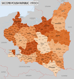
Administrative map comprising the voivodeships of Kraków, Lwów, Stanisławów, and Tarnopol in 1938Administrative divisions of Poland c.1930.Border changes between Galicia and Lodomeria/Poland and Hungary/Czechoslovakia. 1902–58.
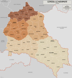
In 1939 at the beginning of World War II Poland was jointly occupied and annexed by Nazi Germany and the Soviet Union in accordance with the Molotov–Ribbentrop Pact. Most of the western parts of the former Galicia and Lodomeria became part of the Nazi General Government, largely forming the Kraków District (Distrikt Krakau), although some additional areas north of Kraków (most of which had incidentally been part of West Galicia) were also included; the northeastern border lay along the San, placing a small part of it in the Lublin District (Distrikt Lublin). The parts furthest to the west became part of Germany-proper within the East Upper Silesia area of Upper Silesia Province. The border between the General Government and what was by this time the Slovak State was restored to that of the pre-1918 Galicia-Hungary border.
The Soviet-annexed formerly Galician territories became the Drohobych, Lviv, Stanislav (now Ivano-Frankivsk) and Tarnopil Oblasts of the Ukrainian SSR, which broadly correspond with the modern Lviv, Ivano-Frankivsk and Ternopil Oblasts (see below).
In July 1941 as part of the Nazi invasion of the Soviet Union the rest of the former Galicia and Lodomeria was annexed by Germany. Some western parts of this territory became part of the Kraków District while the rest formed the District of Galicia (Distrikt Galizien), which also gained a small amount of formerly Galician territory from the Lublin District which had been on the German-side of the 1939 border. The external borders of the District of Galicia (other than with the Kraków District) matched those of the former kingdom.
In Poland today, there are parts of three voivodeships (provinces) that collectively formed the western part of the Kingdom of Galicia and Lodomeria.[13]
Only Podkarpackie Voivodeship ("Subcarpathia") was entirely contained in the Kingdom. The majority of the territory of the Lesser Poland Voivodeship was contained in the Kingdom. From 1795 to 1815, three counties (powiats) that are situated north of the river Vistula were briefly part of the Kingdom: Olkusz County, Miechów County and Proszowice County. By the terms of the treaties of the Congress of Vienna they were annexed to Russian Poland ("Congress Poland") where they remained until the end of World War I. Additionally, the northernmost part of the land-county of Kraków around the villages of Sułoszowa, Skała and Słomniki were similarly allocated to Congress Russia; the remaining parts of the county were located in the Kingdom. The third voivodeship of Silesia contained only a small part of the Kingdom. The Silesian city-county of Jaworzno was originally part of the Kingdom's Chrzanowski county. The majority of the territory of the latter county is still an extant county in modern Poland – Chrzanów County – which is today located in the Lesser Poland voivodeship. The south-eastern Silesian land-counties of Żywiec County and Bielsko County along with the city-county of Bielsko-Biała formed the most westerly part of the Kingdom. The remaining 32 counties of Silesia were never part of the Kingdom.
This section needs to be updated. The reason given is: Needs to be updated to take into account the 2020 administrative reform; most of these raions have been abolished.. Please help update this article to reflect recent events or newly available information.(April 2021)
In Ukraine today, there are three provinces (oblasts) that formed the eastern part of the Kingdom of Galicia and Lodomeria. Two of these – Lviv Oblast and Ivano-Frankivsk Oblast – were entirely contained in the kingdom. The third – Ternopil Oblast – was mainly in the kingdom apart from four of its most northerly raions. These four raions – Kremenets Raion, Shumsk Raion, Lanivtsi and the northern half of Zbarazh Raion – were formerly part of the county of Krzemieniec in the Wolyn Voivodeship (province) of the Second Polish Republic during the interwar period. Prior to World War I, they were part of Congress Poland. They never formed part of the Kingdom of Galicia and Lodomeria. The remaining raions of Ternopil Oblast were all part of the Kingdom of Galicia and Lodomeria.
The government assigned some towns the status of Jewish Administrative Center. These Administrative Centers were responsible for maintaining Jewish vital records.
↑ Regna Galiciae, et Lodomeriae Iosephi II. et M. Theresiae Avgg. Ivssv methodo astronomico trigonometrica, nec non Bukovina geometrice dimensa: Adjectus est alphabeticus locorum, et Quadratulorum, ipsis in Tabula Geographica respondentium index, Seorsum typis datus – Trigonometric map of Galicia and Lodomeria by Joseph Liesganig, 1794. Available from the National Library of Poland here. A version coloured to show the post-1815 Kreise is also available here
↑ Patent vom 28. Februar 1861, RGBl. 20/1861: "February Patent". Reichs-Gesetz-Blatt für das Kaiserthum Österreich. 1861-02-28. Retrieved 2023-07-06– via ÖNB-ALEX - Historische Rechts- und Gesetztexte Online.
This page is based on this Wikipedia article Text is available under the CC BY-SA 4.0 license; additional terms may apply. Images, videos and audio are available under their respective licenses.