Administrative divisions of the Netherlands

Last updated

The Netherlands has several levels of administrative subdivisions. The first level of subdivision consists of 12 provinces. [1] The second level of subdivision consists of 342 municipalities.

Contents

The country is also subdivided into 21 water districts, governed by a water board (waterschap or hoogheemraadschap), each having authority in matters concerning water management. [2] [3] Direct elections of the water boards take place every four years.

Group of provinces

Groups of provinces. Landsdeel.png
Groups of provinces.

The Group of provinces (Dutch : landsdeel) is a European subdivision of the Netherlands. It meets the needs of Eurostat, the European statistical institute, which has defined a classification of territorial units for statistics. These groups correspond to the first European statistical level (NUTS 1).

There are four of them: Northern Netherlands, Eastern Netherlands, Western Netherlands and Southern Netherlands. [4]

Provinces

ProvinceCoat of armsISOCapitalLargest municipalityKing's CommissionerNumber of
municipalities
(since 2023)
Total area [5] Land area [5] Population [5]
(2023)
Population density [5]
km2mi2km2mi2
Flag of Drenthe.svg  Drenthe
Drenthe wapen.svg
NL-DR Assen Emmen Jetta Klijnsma  (PvdA)122,6801,0352,6331,016
502,051
191/km2 (490/sq mi)
Flag of Flevoland.svg  Flevoland
Flevoland wapen.svg
NL-FL Lelystad Almere Arjen Gerritsen  (VVD)62,4129311,410544
444,701
315/km2 (820/sq mi)
Frisian flag.svg  Friesland
Friesland wapen.svg
NL-FR Leeuwarden Arno Brok  (VVD)185,7532,2213,3401,290
659,551
197/km2 (510/sq mi)
Flag of Gelderland.svg  Gelderland
Gelderland wapen.svg
NL-GE Arnhem Nijmegen John Berends  (CDA)515,1361,9834,9601,915
2,133,708
430/km2 (1,100/sq mi)
Flag of Groningen.svg  Groningen
Groningen provincie wapen.svg
NL-GR Groningen René Paas  (CDA)102,9551,1412,316894
596,075
257/km2 (670/sq mi)
Flag of Limburg.svg  Limburg
Limburg-nl-wapen.svg
NL-LI Maastricht Emile Roemer  (SP)312,2108532,145828
1,128,367
526/km2 (1,360/sq mi)
North Brabant-Flag.svg  North Brabant
Noord-Brabant wapen.svg
NL-NB 's-Hertogenbosch Eindhoven Ina Adema  (VVD)565,0821,9624,9021,892
2,626,210
536/km2 (1,390/sq mi)
Flag of North Holland.svg  North Holland
Noord-Holland wapen.svg
NL-NH Haarlem Amsterdam Arthur van Dijk  (VVD)444,0921,5802,6631,028
2,952,622
1,109/km2 (2,870/sq mi)
Flag of Overijssel.svg  Overijssel
Overijssel wapen.svg
NL-OV Zwolle Enschede Andries Heidema  (CU)253,4211,3213,3171,281
1,184,333
357/km2 (920/sq mi)
Flag of Zuid-Holland.svg  South Holland
Zuid-holland wapen.svg
NL-ZH The Hague Rotterdam Jaap Smit  (CDA)503,3081,2772,6981,042
3,804,906
1,410/km2 (3,700/sq mi)
Utrecht (province)-Flag.svg  Utrecht
Utrecht provincie wapen.svg
NL-UT Utrecht Hans Oosters  (PvdA)261,5606021,484573
1,387,643
935/km2 (2,420/sq mi)
Flag of Zeeland.svg  Zeeland
Zeeland wapen.svg
NL-ZE Middelburg Terneuzen Han Polman  (D66)132,9331,1331,780687
391,124
220/km2 (570/sq mi)

COROP regions

A COROP region is a division of the Netherlands for statistical purposes, used by Statistics Netherlands, among others. The Dutch abbreviation stands for Coördinatiecommissie Regionaal Onderzoeksprogramma, literally the Coordination Commission Regional Research Programme. These divisions are also used in the EU designation as NUTS 3.

Water boards

The 21 water boards in The Netherlands in 2019 2019-Waterschap-prov-1200.png
The 21 water boards in The Netherlands in 2019

Typically, a water board's territory is made up of one or more polders or watersheds. The territory of a water board generally covers several municipalities and may even include areas in two or more provinces. As of 2021, there are 21 water boards in The Netherlands. [6]

  1. Waterschap Noorderzijlvest (Groningen, Friesland and Drenthe)
  2. Wetterskip Fryslân (Friesland and Groningen)
  3. Waterschap Hunze en Aa's (Groningen and Drenthe)
  4. Waterschap Drents Overijsselse Delta (Drenthe and Overijssel)
  5. Waterschap Vechtstromen (Drenthe and Overijssel)
  6. Waterschap Vallei en Veluwe (Utrecht and Gelderland)
  7. Waterschap Rijn en IJssel (Gelderland)
  8. Hoogheemraadschap De Stichtse Rijnlanden (Utrecht and South Holland)
  9. Waterschap Amstel, Gooi en Vecht (North Holland, Utrecht and South Holland)
  10. Hoogheemraadschap Hollands Noorderkwartier (North Holland)
  11. Hoogheemraadschap van Rijnland (South Holland and North Holland)
  12. Hoogheemraadschap van Delfland (South Holland)
  13. Hoogheemraadschap van Schieland en de Krimpenerwaard (South Holland)
  14. Waterschap Rivierenland (South Holland, Gelderland, Utrecht and North Brabant)
  15. Waterschap Hollandse Delta (South Holland)
  16. Waterschap Scheldestromen (Zeeland)
  17. Waterschap Brabantse Delta (North Brabant)
  18. Waterschap De Dommel (North Brabant)
  19. Waterschap Aa en Maas (North Brabant)
  20. Waterschap Limburg (Limburg)
  21. Waterschap Zuiderzeeland (Flevoland)

Municipalities

Municipalities of the Netherlands. Gemeenten 2024.png
Municipalities of the Netherlands.

Since 1 January 2023, there have been 342 municipalities (Dutch : gemeenten). Municipalities are the second-level administrative division in the Netherlands and are subdivisions of their respective provinces. Their duties are delegated to them by the central government and they are ruled by a municipal council that is elected every four years. Municipal mergers have reduced the total number of municipalities by two-thirds since the first official boundaries were created in the mid 19th century. Municipalities themselves are informally subdivided into districts and neighbourhoods for administrative and statistical purposes.

These municipalities come in a wide range of sizes, Westervoort is the smallest with a land area of 7.03 km2 (2.71 sq mi) and Súdwest-Fryslân the largest with a land area of 523.01 km2 (201.94 sq mi). Schiermonnikoog is both the least populated and the least densely populated municipality at 23/km2 (60/sq mi). Amsterdam has the highest population with over 900,000 residents (31 March 2022), whereas The Hague is the most densely populated with a density of 6,620/km2 (17,100/sq mi).

Related Research Articles

<span class="mw-page-title-main">Groningen (province)</span> Northeasternmost province of the Netherlands

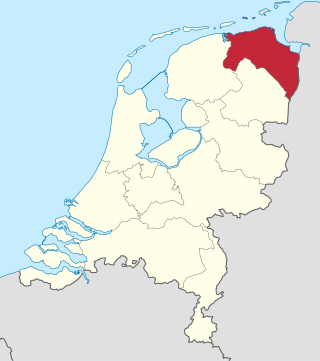
Groningen is the northeasternmost province of the Netherlands. It borders on Friesland to the west, Drenthe to the south, the German state of Lower Saxony to the east, and the Wadden Sea to the north. As of January 2023, Groningen had a population of about 596,000, and a total area of 2,955 km2 (1,141 sq mi).

The Union of Utrecht was a treaty signed on 23 January 1579 in Utrecht, Netherlands, unifying the northern provinces of the Netherlands, until then under the control of Habsburg Spain.

<span class="mw-page-title-main">Drenthe</span> Province of the Netherlands

Drenthe is a province of the Netherlands located in the northeastern part of the country. It is bordered by Overijssel to the south, Friesland to the west, Groningen to the north, and the German state of Lower Saxony to the east. As of January 2023, Drenthe had a population of about 502,000, and a total area of 2,680 km2 (1,030 sq mi).

<span class="mw-page-title-main">Overijssel</span> Province of the Netherlands

Overijssel is a province of the Netherlands located in the eastern part of the country. The province's name translates to "across the IJssel", from the perspective of the Episcopal principality of Utrecht by which it was held until 1528. The capital city of Overijssel is Zwolle and the largest city is Enschede. The province had a population of about 1,184,000 as of January 2023. The land mostly consists of grasslands and some forests ; it also borders a small part of the IJsselmeer to the west.

<span class="mw-page-title-main">Provinces of the Netherlands</span> First-level administrative divisions of the Netherlands

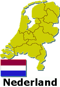
There are twelve provinces of the Netherlands representing the administrative layer between the national government and the local governments, with responsibility for matters of subnational or regional importance.

<span class="mw-page-title-main">Municipalities of the Netherlands</span> Second-level administrative divisions of the Netherlands

Since 1 January 2023, there have been 342 regular municipalities and three special municipalities in the Netherlands. The latter is the status of three of the six island territories that make up the Dutch Caribbean. Municipalities are the second-level administrative division, or public bodies, in the Netherlands and are subdivisions of their respective provinces. Their duties are delegated to them by the central government and they are ruled by a municipal council that is elected every four years. Municipal mergers have reduced the total number of municipalities by two-thirds since the first official boundaries were created in the mid 19th century. Municipalities themselves are informally subdivided into districts and neighbourhoods for administrative and statistical purposes.

This is an armorial of the Kingdom of the Netherlands.

<span class="mw-page-title-main">Young Democrats (Netherlands)</span> Youth wing

The Young Democrats is a social-liberal youth organisation in the Netherlands, founded in 1984. Although independent, it is affiliated with the social-liberal Democrats 66 party. With over 5,000 members, it is the largest political youth organisation of the Netherlands.

<span class="mw-page-title-main">Water board (Netherlands)</span> Water management authorities in the Netherlands

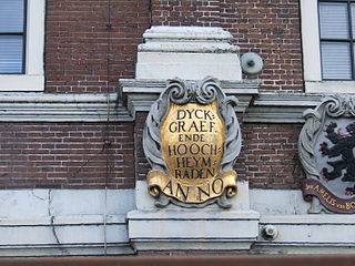
In the Netherlands, a water board, water council or water authority is a regional governing body solely charged with the management of surface water in the environment. Water boards are independent of administrative governing bodies like provinces and municipalities. In general, they are responsible for managing rivers and canals, issues with the flow of watercourses and drainage issues, water collection, flood and erosion prevention and provision of potable water. They manage polder systems, water levels, water barriers and locks, enforcements, water quality and sewage treatment in their respective regions. The concept of a coordinating "High Water Authority" (Hoogheemraadschap) originated in what now is the province of South Holland in the 12th century.

Dutch dialects are primarily the dialects that are both cognate with the Dutch language and spoken in the same language area as the Dutch standard language. They are remarkably diverse and are found within Europe mainly in the Netherlands and northern Belgium.

De Hoop is a name used for mills in Belgium and the Netherlands.

The Dutch Amateur Radio Emergency Service (DARES), which was founded on 12 May 2004, is a non-profit organization made out of licensed radio amateurs in the Netherlands. DARES participants are able to set up a national, continental or international radio network in case of an emergency situation, like a power outage on a large scale, a flooding, a cyber attack causing severe damage to communication networks, or other emergency situations, where the safety of a large group of people are in danger.

Mediahuis Noord, formerly known as NDC Mediagroep, is a Dutch publisher of newspapers, magazines, and websites focused on the three northern provinces of the Netherlands: Drenthe, Friesland and Groningen. It is owned by Mediahuis, a Belgian company. Headquarters are in Leeuwarden, other offices are in Groningen and Meppel. In addition to three main provinces, NDC publishes and distributes also in the Kop van Overijssel, Noordoostpolder, and northern Flevoland.

<span class="mw-page-title-main">2019 Dutch provincial elections</span> Dutch provincial elections held in 2019

Provincial elections were held in the Netherlands on 20 March 2019. Eligible voters elected the members of the Provincial States in the twelve provinces of the Netherlands. The elections were held on the same day as the 2019 Dutch water boards elections and, in the Caribbean Netherlands, island council elections.

<span class="mw-page-title-main">Netherlands–Spain relations</span> Bilateral relations

Netherlands–Spain relations are the bilateral relations between the Netherlands and Spain. The relations between both countries are defined mainly by their membership in the European Union and by being allies in the NATO.

References

  1. Provinces of Netherlands
  2. "De waterschappen" (in Dutch). Archived from the original on 3 November 2013. Retrieved 7 June 2013.
  3. "Mijn waterschap" (in Dutch). Retrieved 6 May 2021.
  4. NUTS 2021 classification
  5. 1 2 3 4 "Regionale kerncijfers Nederland" [Regional key figures Netherlands]. CBS Statline (in Dutch). CBS. 18 December 2023. Retrieved 15 March 2024.
  6. "Zoek Waterschap". waterschappen.nl. Retrieved 2 August 2021.