Subdivisions of Polish territories during World War II

Last updated

Division of interwar Poland
by the occupying powers
1939–41
Occupation of Poland 1939.png
Fourth Partition of Poland – aftermath of the Nazi–Soviet Pact; division of Polish territories in the years 1939–1941
1941–44
Occupation of Poland 1941.png
Changes in administration of Polish territories following the German invasion of the Soviet Union in 1941. The map shows the state in 1944

Subdivision of Polish territories during World War II can be divided into several phases. The territories of the Second Polish Republic were first administered first by Nazi Germany (in the west) and the Soviet Union (in the east), then (following the German invasion of the Soviet Union) in their entirety by Nazi Germany, and finally (following Soviet push westwards) by the Soviet Union again. In 1946, administrative control of the areas not annexed by the Soviet Union was returned to Poland.

Contents

After Germany and the Soviet Union conquered Poland in 1939, they partitioned the country. Germany took most of the ethnically Polish territory. The area annexed by the Soviet Union was ethnically diverse: Poles were the largest single ethnic group, but there were non-Polish majorities in some regions: Ukrainians in the south and Belarusians in the north. [1] Many of these people had felt alienated in the interwar Poland and welcomed the Soviets. [2]

Soviet zone (1939–1941)

By the end of the Polish Defensive War the Soviet Union had taken over 52.1% of the territory of Poland (circa 200,000 km2), with over 13,700,000 people. The estimates vary; Professor Elżbieta Trela-Mazur gives the following numbers in regards to the ethnic composition of these areas: 38% Poles (ca. 5.1 million people), 37% Ukrainians, 14.5% Belarusians, 8.4% Jews, 0.9% Russians and 0.6% Germans. There were also 336,000 refugees from areas occupied by Germany, most of them Jews (198,000). [2] Areas occupied by the USSR were annexed to Soviet territory, with the exception of area of Wilno, which was transferred to Lithuania, although soon attached to USSR, when Lithuania became a Soviet republic.

Under the terms of the Molotov–Ribbentrop pact, adjusted by agreement on 28 September 1939, the Soviet Union, annexed all Polish territory east of the line of the rivers Pisa, Narew, Bug and San, except for the area around Wilno (Vilnius), which was given to Lithuania, and the Suwałki region, which was annexed by Germany. These territories were largely inhabited by Ukrainians and Belarusians, with minorities of Poles and Jews (see exact numbers in Curzon line). The total area, including the area given to Lithuania, was 201,000 square kilometres, with a population of 13.5 million. A small strip of land that was part of Hungary before 1914, was also given to Slovakia.

German zone (1939–1945)

Annexation of selected Polish territories

Under the terms of two decrees by Hitler (8 October and 12 October 1939), large areas of western Poland were annexed to Germany. These included all the territories taken by Prussia in Partitions of Poland which Germany subsequently lost under the 1918 Treaty of Versailles, including the Polish Corridor, Wielkopolska, as well as territories divided after plebiscites such as Upper Silesia, as well as a large area east of these territories, including the city of Łódź.

The area of these annexed territories was 94,000 square kilometres and the population was about 10 million, the great majority of whom were Poles. The annexed parts were controlled by a German administration ruled by a Gauleiter, a system similar in practice to that of the Reich itself. Nearly 1 million Poles were expelled from this German ruled area, while 600,000 Germans from eastern Europe and 400,000 from the German Reich were settled there.

Nazi German administrative unitsAnnexed administrative units
Reichsgau/Gau
(province)
Regierungsbezirk
(government region)
Polish voivodeship/
State
Counties
Reichsgau Wartheland
(Warthegau)
initially Reichsgau Posen [3]
Posen
Hohensalza
Litzmannstadt 5
Poznań all counties
Łódź most counties
Pomeranian five counties
Warsaw one county
Reichsgau Danzig-West Prussia 1
(Danzig-Westpreußen)
initially Reichsgau West Prussia
Bromberg
Danzig 1
Marienwerder 1
Greater Pomeranian most counties
Free City of Danzig
East Prussia 1
(Ostpreußen)
southernmost part2
Zichenau
Gumbinnen 1
Warsaw Ciechanów, Działdowo, Maków, Mława,
Płock, Płońsk, Przasnysz, Sierpc;
parts of Łomża, Ostrołęka, Pułtusk,
Sochaczew, Warsaw
Białystok Suwałki and part of Augustów
Bezirk Bialystok
(attached in 1941)6
Białystok Białystok, Bielsk Podlaski, Grajewo, Łomża,
Sokółka, Volkovysk, Grodno
(Upper) Silesia 1,3
(Oberschlesien)
easternmost part4
Kattowitz
Oppeln 1
Autonomous Silesian
Kielce Sosnowiec, Będzin, Zawiercie, Olkusz
Kraków Chrzanów, Oświęcim, Żywiec [4]
1 Gau or Regierungsbezirk only partially comprised annexed territory

2 the annexed parts are also referred to as "South East Prussia" (German : Südostpreußen)
3 Gau Upper Silesia was created in 1941, before it was part of Gau Silesia
4 the annexed parts are also referred to as "East Upper Silesia" (German : Ostoberschlesien)
5 named after the chief city, Polish : Łódź. The German equivalent Lodz was rendered to Litzmannstadt in 1940, thus the Regierungsbezirk's name was changed accordingly.
6 not incorporated into, but administered by Gau East Prussia, attached after the Nazi German invasion of the Soviet Union, 1941

Creation of General Government

Hans Frank with districts administrators in 1942 from left: Ernst Kundt, Ludwig Fischer, Hans Frank, Otto Wachter, Ernst Zorner, Richard Wendler. Kundt, Fischer, Frank, Wachter, Zorner, Wendler.jpg
Hans Frank with districts administrators in 1942 from left: Ernst Kundt, Ludwig Fischer, Hans Frank, Otto Wächter, Ernst Zörner, Richard Wendler.
Administrative map of the General Government, August 1941 General Government for the occupied Polish territories.png
Administrative map of the General Government, August 1941

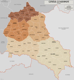
The remaining block of territory was placed under a German administration called the General Government (in German Generalgouvernement für die besetzten polnischen Gebiete), with its capital at Kraków. The General Government was subdivided into four districts, Warsaw, Lublin, Radom, and Kraków (Distrikt Krakau).

A German lawyer and prominent Nazi, Hans Frank, was appointed "Governor-General of the occupied Polish territories" on 26 October 1939. Frank oversaw the segregation of the Jews into Nazi ghettos in the larger cities, particularly Warsaw, and the use of Polish civilians as forced and slave labour in German war industries.

German invasion of the Soviet Union

After Operation Barbarossa, the June 1941 German invasion of the Soviet Union, the Polish territories previously annexed to the Ukrainian and Byelorussian republics were organized by the Germans as follows:

Return of Soviet administration (1944–1945)

Soviet forces returned to former territories of the Second Polish Republic during the 1944 summer offensive, Operation Bagration, specifically in the Lublin–Brest Offensive), leading to Vistula–Oder Offensive of 1945. However, in terms of international politics, a far more important victory was won by Joseph Stalin already in 1943, when the Western Allies yielded to his demands during the Tehran Conference, for the annexation of eastern Poland by the Soviet Union. [5]

With full Soviet control and sponsorship, in July 1944, the Polish Committee of National Liberation (Polski Komitet Wyzwolenia Narodowego, PKWN), a Polish provisional government was formed. Its purpose was to administer the territories earmarked for the return to the newly reformed Poland. Starting with the communist decrees of 1946, the legal powers were passed on to local administration (see Administrative division of People's Republic of Poland). [6]

Destruction of the Polish Underground State

Throughout World War II, Poland had a unique underground administration maintained by the Polish Underground State. For regional divisions of Poland by the underground army known as Armia Krajowa, see areas and regions of operation. Following the German surrender, Soviet agencies such as NKVD and SMERSH proceeded to eliminate all structures originating from the prewar Second Polish Republic. Over 20,000 Poles, including the hero of Auschwitz, Witold Pilecki, were murdered in communist prisons. [7]

See also

Notes

  1. Jan Tomasz Gross, Revolution from Abroad, pp. 4, 5, Princeton, 2005, ISBN   0-691-09603-1
  2. 1 2 Elżbieta Trela-Mazur (1997). Włodzimierz Bonusiak; Stanisław Jan Ciesielski; Zygmunt Mańkowski; Mikołaj Iwanow (eds.). Sowietyzacja oświaty w Małopolsce Wschodniej pod radziecką okupacją 1939–1941. Kielce: Wyższa Szkoła Pedagogiczna im. Jana Kochanowskiego. p. 294. ISBN   8371331002 via Google Books. Of the 13.5 million civilians living in Polish areas annexed by the Soviet Union according to the last official Polish census, the population was over 38% Poles (5.1 million), 37% Polish Ukrainians (4.7 million), 14.5% Belarusians, 8.4% Jews, 0.9% Russians and 0.6% Germans.{{cite book}}: |work= ignored (help)
  3. Piotr Eberhardt, Political Migrations in Poland, 1939–1948, Warsaw 2006, "Archived copy" (PDF). Archived from the original (PDF) on 18 October 2011. Retrieved 8 February 2016.{{cite web}}: CS1 maint: archived copy as title (link): 10,568,000 people
  4. Ryszard Kaczmarek Górnoślązacy i górnośląscy gauleiterzy Biuletyn IPN NR 6–7 (41–42) 2004 page 46
  5. Robert Gellately (2013). Stalin's Curse: Battling for Communism in War and Cold War. Oxford U.P. pp. 177–178. ISBN   9780191644887.
  6. Norman Davies, God's Playground: A History of Poland. Vol 2. New York: Columbia University Press, 1982 and several reprints. ISBN   0-231-05353-3 and ISBN   0-231-05351-7.
  7. Rzeczpospolita, 02.10.04 Nr 232, Wielkie polowanie: Prześladowania akowców w Polsce Ludowej (Great hunt: the persecutions of AK soldiers in the People's Republic of Poland). Internet Archive.

Related Research Articles

<span class="mw-page-title-main">Curzon Line</span> Historical demarcation of territories of Poland and the Soviet Union

The Curzon Line was a proposed demarcation line between the Second Polish Republic and the Soviet Union, two new states emerging after World War I. Based on a suggestion by Herbert James Paton, it was first proposed in 1919 by Lord Curzon, the British Foreign Secretary, to the Supreme War Council as a diplomatic basis for a future border agreement.

<span class="mw-page-title-main">History of Poland (1939–1945)</span> Period of Polish history during World War II

The history of Poland from 1939 to 1945 encompasses primarily the period from the invasion of Poland by Nazi Germany and the Soviet Union to the end of World War II. Following the German–Soviet non-aggression pact, Poland was invaded by Nazi Germany on 1 September 1939 and by the Soviet Union on 17 September. The campaigns ended in early October with Germany and the Soviet Union dividing and annexing the whole of Poland. After the Axis attack on the Soviet Union in the summer of 1941, the entirety of Poland was occupied by Germany, which proceeded to advance its racial and genocidal policies across Poland.

<span class="mw-page-title-main">Territories of Poland annexed by the Soviet Union</span> 1939 Soviet Union invasion of Poland

Seventeen days after the German invasion of Poland in 1939, which marked the beginning of the Second World War, the Soviet Union entered the eastern regions of Poland and annexed territories totalling 201,015 square kilometres (77,612 sq mi) with a population of 13,299,000. Inhabitants besides ethnic Poles included Belarusian and Ukrainian major population groups, and also Czechs, Lithuanians, Jews, and other minority groups.

<span class="mw-page-title-main">Reichskommissariat Ostland</span> Belarus, Lithuania, Latvia and Estonia as occupied by Germany during the Second World War

The Reichskommissariat Ostland (RKO) was established by Nazi Germany in 1941 during World War II. It became the civilian occupation regime in Lithuania, Latvia, Estonia, and the western part of Byelorussian SSR. German planning documents initially referred to an equivalent Reichskommissariat Baltenland. The political organization for this territory – after an initial period of military administration before its establishment – involved a German civilian administration, nominally under the authority of the Reich Ministry for the Occupied Eastern Territories led by Nazi ideologist Alfred Rosenberg, but actually controlled by the Nazi official Hinrich Lohse, its appointed Reichskommissar.

<span class="mw-page-title-main">Kresy</span> Former eastern regions of Poland

Eastern Borderlands or simply Borderlands was a term coined for the eastern part of the Second Polish Republic during the interwar period (1918–1939). Largely agricultural and extensively multi-ethnic with a Polish minority, it amounted to nearly half of the territory of interwar Poland. Historically situated in the eastern Polish–Lithuanian Commonwealth, following the 18th-century foreign partitions it was divided between the Empires of Russia and Austria-Hungary, and ceded to Poland in 1921 after the Treaty of Riga. As a result of the post-World War II border changes, all of the territory was ceded to the USSR, and none of it is in modern Poland.

<span class="mw-page-title-main">Kobryn</span> Town in Brest Region, Belarus

Kobryn or Kobrin is a town in Brest Region, Belarus. It serves as the administrative center of Kobryn District. It is located in the southwestern corner of Belarus, where the Mukhavets river and Dnieper–Bug Canal meet. The town lies about 52 kilometres (32 mi) east of the city of Brest. As of 2023, it has a population of 52,670.

<span class="mw-page-title-main">Braslaw</span> Town in Vitebsk Region, Belarus

Braslaw or Braslav is a town in Vitebsk Region, Belarus. It serves as the administrative center of Braslaw District. As of 2023, it has a population of 9,426.

<i>Reichskommissariat Ukraine</i> Civilian-administered region of German-occupied Ukraine during WWII

During World War II, Reichskommissariat Ukraine was the civilian occupation regime of much of Nazi German-occupied Ukraine. It was governed by the Reich Ministry for the Occupied Eastern Territories headed by Alfred Rosenberg. Between September 1941 and August 1944, the Reichskommissariat was administered by Erich Koch as the Reichskommissar. The administration's tasks included the pacification of the region and the exploitation, for German benefit, of its resources and people. Adolf Hitler issued a Führer decree defining the administration of the newly-occupied Eastern territories on 17 July 1941.

<span class="mw-page-title-main">Western Belorussia</span> Historical region of Belarus

Western Belorussia or Western Belarus is a historical region of modern-day Belarus which belonged to the Second Polish Republic during the interwar period. For twenty years before the 1939 invasion of Poland, it was the northern part of the Polish Kresy macroregion. Following the end of World War II in Europe, most of Western Belorussia was ceded to the Soviet Union by the Allies, while some of it, including Białystok, was given to the Polish People's Republic. Until the dissolution of the Soviet Union in 1991, Western Belorussia formed the western part of the Byelorussian Soviet Socialist Republic (BSSR). Today, it constitutes the west of modern Belarus.

The Belarusian minority in Poland is composed of 47,000 people according to the Polish census of 2011. This number decreased in the last decades from over 300,000 due to an active process of assimilation. Most of them live in the Podlaskie Voivodeship.

<span class="mw-page-title-main">German occupation of the Baltic states during World War II</span>

After the German invasion of the Soviet Union, the Baltic states were under military occupation by Nazi Germany from 1941 to 1944. Initially, many Estonians, Latvians, and Lithuanians considered the Germans liberators from the Soviet Union.

<span class="mw-page-title-main">Bialystok District</span> Nazi German administrative unit in occupied Eastern Poland

Bialystok District was an administrative unit of Nazi Germany created during the World War II invasion of the Soviet Union. It was to the south-east of East Prussia, in present-day northeastern Poland as well as in smaller sections of adjacent present-day Belarus and Lithuania. It was sometimes also referred to by the designation South East Prussia along with the Regierungsbezirk Zichenau, although in contrast to the latter, it was not incorporated into, but merely attached to East Prussia.

<span class="mw-page-title-main">Polish population transfers (1944–1946)</span> Post WWII resettlement

The Polish population transfers in 1944–1946 from the eastern half of prewar Poland, were the forced migrations of Poles toward the end and in the aftermath of World War II. These were the result of a Soviet Union policy that had been ratified by the main Allies of World War II. Similarly, the Soviet Union had enforced policies between 1939 and 1941 which targeted and expelled ethnic Poles residing in the Soviet zone of occupation following the Nazi-Soviet invasion of Poland. The second wave of expulsions resulted from the retaking of Poland from the Wehrmacht by the Red Army. The USSR took over territory for its western republics.

The Holocaust in Belarus refers to the systematic extermination of Jews living in the Byelorussian Soviet Socialist Republic during its occupation by Nazi Germany in World War II. It is estimated that roughly 800,000 Belarusian Jews were murdered during the Holocaust. However, other estimates place the number of Jews killed between 500,000 and 550,000.

<span class="mw-page-title-main">Dzisna</span> Town in Vitebsk Region, Belarus

Dzisna is a town in Miory District, Vitebsk Region, Belarus. It is located on the left bank of the Daugava River, near the confluence of the Dysna. In 2017, its population was 1,500 inhabitants. As of 2023, it has a population of 1,417.

<span class="mw-page-title-main">Polish–Soviet border agreement of August 1945</span> 1945 border agreement

The Border Agreement between Poland and the USSR of 16 August 1945 established the borders between the Union of Soviet Socialist Republics (USSR) and the Republic of Poland. It was signed by the Provisional Government of National Unity formed by the Polish communists. According to the treaty, Poland officially accepted the ceding its pre-war Eastern territory to the USSR (Kresy) which was decided earlier in Yalta already. Some of the territory along the Curzon line, established by Stalin during the course of the war, was returned to Poland. The treaty also recognised the division of the former German East Prussia and ultimately approved the finalised delimitation line between the Soviet Union and Poland: from the Baltic sea, to the border tripoint with Czechoslovakia in the Carpathians. The agreement entered into force on 5 February 1946.

<span class="mw-page-title-main">Elections to the People's Assemblies of Western Ukraine and Western Belorussia</span>

Elections to the People's Assemblies of Western Ukraine and Western Belorussia, which took place on October 22, 1939, were an attempt to legitimize the annexation of the Second Polish Republic's eastern territories by the Soviet Union following the September 17 Soviet invasion of Poland in accordance with the secret protocol of the Molotov–Ribbentrop Pact. Only one month after these lands were occupied by the Red Army, the Soviet secret police and military led by the Party officials staged the local elections in an atmosphere of state terror. The referendum was rigged. The ballot envelopes were numbered and often handed over already sealed. By design, the candidates were unknown to their constituencies which were brought to the voting stations by armed militias. The results were to become the official legitimization of the Soviet takeover of what is known today as the Western Belorussia and the Western Ukraine. Consequently, both Assemblies voted for incorporation of all formerly Polish voivodeships into the Soviet Union.

<span class="mw-page-title-main">Occupation of Poland (1939–1945)</span> Occupation of Poland during WWII

The occupation of Poland by Nazi Germany and the Soviet Union during World War II (1939–1945) began with the German-Soviet invasion of Poland in September 1939, and it was formally concluded with the defeat of Germany by the Allies in May 1945. Throughout the entire course of the occupation, the territory of Poland was divided between Nazi Germany and the Soviet Union (USSR), both of which intended to eradicate Poland's culture and subjugate its people. In the summer-autumn of 1941, the lands which were annexed by the Soviets were overrun by Germany in the course of the initially successful German attack on the USSR. After a few years of fighting, the Red Army drove the German forces out of the USSR and crossed into Poland from the rest of Central and Eastern Europe.

Generalbezirk Weißruthenien was one of the four administrative subdivisions of Reichskommissariat Ostland, the 1941–1945 civilian occupation regime established by Nazi Germany for the administration of the three Baltic countries and the western part of the Byelorussian SSR.