Related Research Articles
The administrative division reform of 1708 was carried out by Russian Tsar Peter the Great in an attempt to improve the manageability of the vast territory of Russia. Prior to the reform, the country was subdivided into uyezds and volosts, and in the 17th century the number of the uyezds was 166.
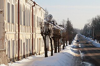
Opochka is a town and the administrative center of Opochetsky District in Pskov Oblast, Russia, located on the Velikaya River, 130 kilometers (81 mi) south of Pskov, the administrative center of the oblast. Population: 11,603 (2010 Census); 13,964 (2002 Census); 16,190 (1989 Soviet census).; 9,928.
An uezd, or povit in a Ukrainian context was a type of administrative subdivision of the Grand Duchy of Moscow, the Tsardom of Russia, the Russian Empire, the Russian SFSR, and the early Soviet Union, which was in use from the 13th century. For most of Russian history, uezds were a second-level administrative division. By sense, but not by etymology, uezd approximately corresponds to the English "county".

Smolensk Governorate was an administrative-territorial unit (guberniya) of the Tsardom of Russia, the Russian Empire, and the Russian SFSR. It existed, with interruptions, between 1708 and 1929.
Zubtsov is a town and the administrative center of Zubtsovsky District in Tver Oblast, Russia, located at the confluence of the Volga and Vazuza Rivers, 153 kilometers (95 mi) south of Tver, the administrative center of the oblast. Population: 6,927 (2010 Census); 7,430 (2002 Census); 7,630 (1989 Soviet census); 8,100.

Sebezh is a town and the administrative center of Sebezhsky District in Pskov Oblast, Russia, located in a picturesque setting between Lakes Sebezhskoye and Orono 189 kilometers (117 mi) south of Pskov, the administrative center of the oblast. Population: 6,375 (2010 Census); 7,138 (2002 Census); 9,497 (1989 Soviet census).
Novorzhev is a town and the administrative center of Novorzhevsky District in Pskov Oblast, Russia, located on the Sorot River 144 kilometers (89 mi) southeast of Pskov, the administrative center of the oblast. Population: 3,695 (2010 Census); 4,125 (2002 Census); 5,050 (1989 Soviet census).
Novosokolniki is a town and the administrative center of Novosokolnichesky District in Pskov Oblast, Russia, located on the Maly Udray River at the junction of the St. Petersburg–Kyiv and Moscow–Riga railways, 287 kilometers (178 mi) southeast of Pskov, the administrative center of the oblast. Population: 8,119 (2010 Census); 9,757 (2002 Census); 10,689 (1989 Soviet census).

Archangelgorod Governorate was an administrative-territorial unit (guberniya) of the Tsardom of Russia and the Russian Empire, which existed from 1708 until 1780. Its seat was in Archangel (Arkhangelsk). The governorate was located in the north of the Russian Empire and bordered Siberia Governorate in the east, Kazan Governorate in the southeast, Moscow and Ingermanland Governorates in the southwest, Sweden in the west, and Norway in north-west. In the north, the governorate was limited by the White and Barents Seas.

The Moscow Governorate was a province (guberniya) of the Tsardom of Russia, and the Russian Empire. It was bordered by Tver Governorate to the north, Vladimir Governorate to the northeast, Ryazan Governorate to the southeast, Tula Governorate to the south, Kaluga Governorate to the southwest, and Smolensk Governorate to the west. Moscow Governorate consisted of an area of 33,272.84 square kilometres (12,846.72 sq mi) and a population of 2,430,581 in 1897. Its capital was in Moscow.

Kiev Viceroyalty was an administrative-territorial unit (namestnichestvo) of the Russian Empire, which existed in 1781–1796. It was created in the process of Catherine's reforms initiated by edict of November 7, 1775.
Western Oblast was an administrative-territorial unit (oblast) of the Russian SFSR from 1929 to 1937. Its seat was in the city of Smolensk. The oblast was located in the west of European Russia, and its territory is currently divided between Bryansk, Kaluga, Pskov, Smolensk, and Tver Oblasts.
Kuban Black Sea Oblast was an administrative division of the Russian Soviet Federative Socialist Republic which existed in 1920–1924.

Northern Krai was an administrative-territorial unit (krai) of the Russian SFSR from 1929 to 1936. Its seat was in the city of Arkhangelsk. The krai was located in the north of European Russia, and its territory is currently divided between Arkhangelsk, Vologda, Kostroma, and Kirov Oblasts, the Nenets Autonomous Okrug, and the Komi Republic.

Gdovsky District is an administrative and municipal district (raion), one of the twenty-four in Pskov Oblast, Russia. It is located in the northwest of the oblast and borders with Slantsevsky District of Leningrad Oblast in the north, Plyussky District in the east, Strugo-Krasnensky District in the southeast, and with Pskovsky District in the south. Lake Peipus forms the border with Estonia in the west. The area of the district is 3,400 square kilometers (1,300 sq mi). Its administrative center is the town of Gdov. Population: 12,792 (2010 Census); 17,715 ; 19,842 (1989 Soviet census). The population of Gdov accounts for 34.2% of the district's total population.

Azov Governorate was an administrative-territorial unit (guberniya) of the Russian Empire, which existed from 1775 to 1783. Its capital was in Belyov Fortress and later in Yekaterinoslav.

Kiev Governorate was an administrative-territorial unit (guberniya) of the Tsardom of Russia and the Russian Empire. It was established in December 1708 as one of the eight guberniyas first created during the reforms of Peter the Great.

Simbirsk Governorate was an administrative-territorial unit (guberniya) of the Russian Empire and the Russian SFSR, which existed from 1796 to 1928. Its administrative center was in the city of Simbirsk, renamed Ulyanovsk in 1924.

Peno is an urban-type settlement and the administrative center of Penovsky District of Tver Oblast, Russia. It is located between Lake Peno and Lake Volgo, both located in the course of the Volga River and belonging to Upper Volga Reservoir. Population: 4,220 (2010 Census); 5,358 (2002 Census); 6,212 (1989 Soviet census).
References
- 1 2 3 Tsutsiev, Arthur (2014). Atlas of the Ethno-Political History of the Caucasus (PDF). Translated by Nora Seligman Favorov. New Haven: Yale University Press. ISBN 9780300153088. Archived (PDF) from the original on 17 June 2023.
- ↑ С. А. Тархов (2001). "Изменение административно-территориального деления России за последние 300 лет". Электронная версия журнала "География". Archived from the original on 2013-11-13.
- 1 2 Кавказский календарь на 1913 год [Caucasian calendar for 1913] (in Russian) (68th ed.). Tiflis: Tipografiya kantselyarii Ye.I.V. na Kavkaze, kazenny dom. 1913. Archived from the original on 19 April 2022.