
Hesse or Hessia, officially the State of Hessen, is a state in Germany. Its capital city is Wiesbaden, and the largest urban area is Frankfurt. With an area of 21,000 square kilometers and a population of just over six million it ranks seventh and fifth respectively among the sixteen German states. Frankfurt Rhine-Main, Germany's second-largest metropolitan area, is mainly located in Hesse.

Spessart is a Mittelgebirge, a range of low wooded mountains, in the States of Bavaria and Hesse in Germany. It is bordered by the Vogelsberg, Rhön and Odenwald. The highest elevation is the Geiersberg at 586 metres above sea level.

The Rhön Mountains are a group of low mountains in central Germany, located around the border area where the states of Hesse, Bavaria and Thuringia come together. These mountains, which are at the extreme southeast end of the East Hesse Highlands, are partly a result of ancient volcanic activity. They are separated from the Vogelsberg Mountains by the river Fulda and its valley. The highest mountain in the Rhön is the Wasserkuppe which is in Hesse. The Rhön Mountains are a popular tourist destination and walking area.

The Kinzig is a river, 87 kilometres long, in southern Hesse, Germany. It is a right tributary of the Main. Its source is in the Spessart hills at Sterbfritz, near Schlüchtern. The Kinzig flows into the Main in Hanau. The Main-Kinzig-Kreis (district) was named after the river. The towns along the Kinzig are Schlüchtern, Steinau an der Straße, Bad Soden-Salmünster, Gelnhausen, and Hanau. The Kinzig is first recorded in 815 A.D. as Chinzicha.

Aura im Sinngrund is a community in the Main-Spessart district in the Regierungsbezirk of Lower Franconia (Unterfranken) in Bavaria, Germany and a member of the Verwaltungsgemeinschaft of Burgsinn.

Mittelsinn is a community in the Main-Spessart district in the Regierungsbezirk of Lower Franconia (Unterfranken) in Bavaria, Germany and a member of the Verwaltungsgemeinschaft of Burgsinn.
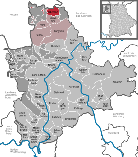
Obersinn is a market community in the Main-Spessart district in the Regierungsbezirk of Lower Franconia (Unterfranken) in Bavaria, Germany and a member of the Verwaltungsgemeinschaft of Burgsinn.
Flörsbachtal is a municipality in the Main-Kinzig district, in Hesse, Germany. It has a population close to 2,400. Flösbachtal contains both the oldest parish and the youngest settlement established in the Spessart hills. Located within the municipal territory is the Hermannskoppe, the highest elevation in the Hessian part of the Spessart and the Wiesbüttmoor, a rare hanging bog.

Sinntal is a municipality in the Main-Kinzig district, in Hesse, Germany. It has a population of around 8,900.

The Ludwig Western Railway is a German railway line that was originally funded by the Kingdom of Bavaria. It runs from Bamberg via Würzburg to Aschaffenburg and on into the former "Kurhessian" Hanau.

The Sinn is a river that flows through the state of Hesse and the Bavarian province of Lower Franconia in southern Germany. It is about 69 kilometres (43 mi) long and is a right, northerly tributary of the Franconian Saale.
The East Hesse Highlands describes a heavily wooded range of hills lying mainly in the German state of Hesse, but also extending a little way into Lower Saxony to the north, Thuringia to the east and Bavaria to the southeast. The region is sandwiched between the West Hesse Depression to the west, the Weser Uplands to the north, the Thuringian Basin to the northeast, the northwestern edge of the Thuringian Forest to the east, the Spessart to the south and the Wetterau to the southwest.

Jossa is a river of Hesse, Germany. It is a tributary of the Sinn, which in turn flows into the Franconian Saale shortly before the latter discharges into the Main at Gemünden am Main.

Lohrbach is a small river in the municipality of Flörsbachtal in the Main-Kinzig district of Hesse, Germany.

The Hessian Rhön Nature Park lies east of Fulda in East Hesse on the border with Thuringia and Bavaria and has and area of 720,7 km². Together with the Bavarian Rhön Nature Park it is part of the cross-border Rhön Biosphere Reserve.
Spessart Nature Park is a nature park in Germany, managed by Naturpark Spessart e. V. The park spans the states of Hesse and Bavaria, and covers an area of 2,440 km² within the German hill range known as the Spessart. The geological foundation of the park is formed by a Bunter sandstone plate, up to about 400 metres thick, which tilts towards the southeast. The nature park includes the largest contiguous area of mixed forest in Germany. Deep valleys, gentle hillsides and heights characterise the landscape of the Spessart.
The Hesse Highlands, Hessian Highlands or Hessian Highlands and Lowlands, are a largely densely forested low mountain area in the German state of Hesse that lies between the Rhenish Massif and the western edge of the Thuringian Basin. The Hesse Highlands are both part of the German Central Uplands and the Rhine-Weser Watershed.

The Vogelsberg (help·info) is a large volcanic mountain range in the German Central Uplands in the state of Hesse, separated from the Rhön Mountains by the Fulda river valley. Emerging approximately 19 million years ago, the Vogelsberg is Central Europe's largest basalt formation, consisting of a multitude of layers that descend from their peak in ring-shaped terraces to the base.
