Sinntal

Last updated
Sinntal
Wappen Sinntal.svg
Location of Sinntal within Main-Kinzig-Kreis district
Sinntal in MKK.svgSchöneckRodenbachNeubergRonneburg
Germany adm location map.svg
Red pog.svg
Sinntal
Hesse location map.svg
Red pog.svg
Sinntal
Coordinates: 50°16′N9°38′E / 50.267°N 9.633°E / 50.267; 9.633
Country Germany
State Hesse
Admin. region Darmstadt
District Main-Kinzig-Kreis
Subdivisions12 districts
Government
   Mayor (202228) Thomas Henfling [1]
Area
  Total111.83 km2 (43.18 sq mi)
Highest elevation
585 m (1,919 ft)
Lowest elevation
220 m (720 ft)
Population
 (2022-12-31) [2]
  Total8,840
  Density79/km2 (200/sq mi)
Time zone UTC+01:00 (CET)
  Summer (DST) UTC+02:00 (CEST)
Postal codes
36391
Dialling codes 06664,
06665 (Altengronau, Jossa, Neuengronau),
09741 (Züntersbach)
Vehicle registration MKK, GN, SLÜ
Website www.sinntal.de

Sinntal is a municipality in the Main-Kinzig district, in Hesse, Germany. It has a population of around 8,800.

Contents

Geography

Location

Sinntal is located around 30 km south of Fulda in the Main-Kinzig district of Hesse.

The municipal territory lies at elevations between 220 and 585 m above NHN. It includes area in the Mittelgebirge Spessart and Rhön. [3]

Sinntal is located right at the border between Hesse and Bavaria. It stretches across the valley of the Sinn river from which it takes its name.

Subdivisions

Sinntal consists of the following Ortsteile :

Neighbouring communities

Sinntal borders on (from the north, clockwise): Kalbach (Hesse), Motten, the unincorporated area Mottener Forst-Süd  [ de ], Bad Brückenau, Zeitlofs, the unincorporated area Roßbacher Forst  [ de ], Obersinn (all Bavaria), the unincorporated area Gutsbezirk Spessart (Hesse) and Schlüchtern (Hesse).

Governance

The mayor of Sinntal is Thomas Henfling (since 2022).

Infrastructure

Transport

Sinntal lies on the Hanover-Würzburg high-speed rail line. Germany's longest tunnel, the Landrücken Tunnel is located in the northern part of the municipal territory.

The closest motorway is the Bundesautobahn 7. The nearest interchange is in "Bad Brückenau".

Related Research Articles

Main-Kinzig-Kreis is a Kreis (district) in the east of Hesse, Germany. Neighboring districts are Wetteraukreis, Vogelsbergkreis, Fulda, Bad Kissingen, Main-Spessart, Aschaffenburg, Offenbach and the district-free cities of Offenbach and Frankfurt.

<span class="mw-page-title-main">Hainburg, Germany</span> Municipality in Hesse, Germany

Hainburg is a municipality of just under 14,400 inhabitants in the Offenbach district in the Regierungsbezirk of Darmstadt in Hesse, Germany.

<span class="mw-page-title-main">Lahntal</span> Municipality in Hesse, Germany

The municipality of Lahntal is found in the Marburg-Biedenkopf district in northwest Middle Hesse, Germany.

<span class="mw-page-title-main">Twistetal</span> Municipality in Hesse, Germany

Twistetal is a municipality in Waldeck-Frankenberg in northwest Hesse, Germany, southwest of Bad Arolsen.

<span class="mw-page-title-main">Bad Soden-Salmünster</span> Town in Hesse, Germany

Bad Soden-Salmünster is a town in the Main-Kinzig district, in Hesse, Germany. It is situated on the river Kinzig, between Fulda and Hanau. It has a population of around 13,000.

<span class="mw-page-title-main">Wächtersbach</span> Town in Hesse, Germany

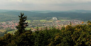
The town of Wächtersbach is part of the Main-Kinzig-Kreis in Hesse, Germany. In 1982, the town hosted the 22nd Hessentag state festival.

<span class="mw-page-title-main">Bad Zwesten</span> Municipality in Hesse, Germany

Bad Zwesten is a municipality in the Schwalm-Eder district of Hesse, Germany.

<span class="mw-page-title-main">Freigericht</span> Municipality in Hesse, Germany

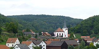
Freigericht is a municipality in the Main-Kinzig district, in Hesse, Germany. It is situated 15 km east of Hanau, close to the Frankfurt Rhein-Main region at the foothills of the Spessart, directly at the Hesse-Bavaria border. More than 40% of the area is forested.

<span class="mw-page-title-main">Freiensteinau</span> Municipality in Hesse, Germany

Freiensteinau is a municipality in the Vogelsbergkreis in Hesse, Germany.

<span class="mw-page-title-main">Steinau an der Straße</span> Town in Hesse, Germany

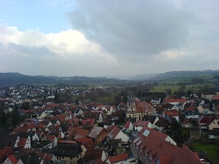
Steinau an der Straße is a town of around 10,000 inhabitants in the Main-Kinzig district, in Hesse, Germany. It is situated on the river Kinzig, 32 kilometres (20 mi) southwest of Fulda. The name Steinau refers to stones in the river; an der Straße, meaning on the road, refers to the historic trade route Via Regia from Leipzig to Frankfurt on which it was located. Steinau is best known for the Brothers Grimm who spent part of their childhood here.

<span class="mw-page-title-main">Bad König</span> Town in Hesse, Germany

Bad König is a town and resort (Kurort) in the central Odenwald in the Odenwaldkreis (district) in Hesse, Germany, 29 km southeast of Darmstadt.

<span class="mw-page-title-main">Bad Orb</span> Town in Hesse, Germany

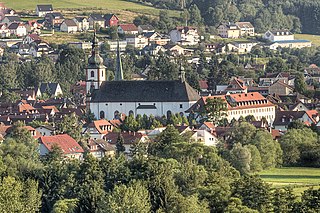
Bad Orb is a spa town in the Main-Kinzig-Kreis district of Hesse, Germany. It is situated 32 kilometres (20 mi) east of Hanau between the forested hills of the Spessart. Bad Orb has a population of over 10,000. Its economy is dominated by the health and tourism sectors.

<span class="mw-page-title-main">Flieden</span> Municipality in Hesse, Germany

Flieden is a municipality in the district of Fulda, in Hesse, Germany. Traditionally called a “Königreich” (Kingdom), it may show a crown in its coat of arms.

<span class="mw-page-title-main">Biebergemünd</span> Municipality in Hesse, Germany

Biebergemünd is a municipality in the Main-Kinzig district, in Hesse, Germany. It has a population of over 8,000 and lies in the wooded hills of the Spessart.

<span class="mw-page-title-main">Flörsbachtal</span> Municipality in Hesse, Germany

Flörsbachtal is a municipality in the Main-Kinzig district, in Hesse, Germany. It has a population close to 2,400. Flösbachtal contains both the oldest parish and the youngest settlement established in the Spessart hills. Located within the municipal territory is the Hermannskoppe, the highest elevation in the Hessian part of the Spessart and the Wiesbüttmoor, a rare hanging bog.

<span class="mw-page-title-main">Großkrotzenburg</span> Municipality in Hesse, Germany

Großkrotzenburg is a municipality in the Main-Kinzig district, in Hesse, Germany. It has a population of around 7,500.

<span class="mw-page-title-main">Jossgrund</span> Municipality in Hesse, Germany

Jossgrund is a municipality in the Main-Kinzig district, in Hesse, Germany. It has around 3,500 inhabitants distributed among several formerly independent villages, now Ortsteile. The administration seat is at Oberndorf.

<span class="mw-page-title-main">Linsengericht</span> Municipality in Hesse, Germany

Linsengericht is a municipality in the Main-Kinzig district, in Hesse, Germany.

<span class="mw-page-title-main">Fränkisch-Crumbach</span> Municipality in Hesse, Germany

Fränkisch-Crumbach is a municipality in the Odenwaldkreis (district) in Hesse, Germany.

<span class="mw-page-title-main">Lützelbach</span> Municipality in Hesse, Germany

Lützelbach is a municipality in the Odenwaldkreis (district) in Hesse, Germany.

References

  1. "Ergebnisse der jeweils letzten Direktwahl von Landrätinnen und Landräte sowie (Ober-)Bürgermeisterinnen und (Ober-)Bürgermeister in Hessen, Stand 13.04.2023" (XLS) (in German). Hessisches Statistisches Landesamt.
  2. "Bevölkerung in Hessen am 31.12.2022 nach Gemeinden" (XLS) (in German). Hessisches Statistisches Landesamt. June 2023.
  3. "Daten und Anfahrt (German)". Gemeinde Sinntal. Retrieved 8 April 2016.