Motten

Last updated

Motten
Motten Motten Catholic Church s.png
Church of Saint Bartholomew
DEU Motten COA.svg
Coat of arms
Location of Motten within Bad Kissingen district
Motten in KG.svg
Germany adm location map.svg
Red pog.svg
Motten
Bavaria location map.svg
Red pog.svg
Motten
Coordinates: 50°24′N9°46′E / 50.400°N 9.767°E / 50.400; 9.767 Coordinates: 50°24′N9°46′E / 50.400°N 9.767°E / 50.400; 9.767
Country Germany
State Bavaria
Admin. region Unterfranken
District Bad Kissingen
Subdivisions3 Ortsteile
Government
   Mayor (202026) Katja Habersack [1]
Area
  Total23.80 km2 (9.19 sq mi)
Elevation
420 m (1,380 ft)
Population
 (2020-12-31) [2]
  Total1,672
  Density70/km2 (180/sq mi)
Time zone UTC+01:00 (CET)
  Summer (DST) UTC+02:00 (CEST)
Postal codes
97786
Dialling codes 09748
Vehicle registration KG
Website www.motten.de
St.-Bartholomaus Motten Motten Catholic Church d.png
St.-Bartholomäus

Motten is a municipality in the district of Bad Kissingen in Bavaria in Germany.

Contents

Geography

Subdivisions

The municipality consists of the following Ortsteile :

History

Motten originally belonged to the Bishop of Fulda, and was secularized in 1803 and given to Archduke Ferdinand of Orange. In 1806, it became part of the Province of Fulde in France. In the Congress of Vienna in 1815, it was given to Austria. Since the Treaty of Munich of 1816, it has belonged to Bavaria.

On the evening of 22 October 2005, a tornado destroyed parts of the industrial district.

Demographics

YearPopulation
19611491
19701617
19871641
19911741
19951961
20001946
20021946
20051935
20101794
20151771

Economy

Motten has had a brewery since the 16th century.

In 1998, there were 242 businesses in the municipality. In 1999, there were 54 agricultural businesses, with 837 ha under cultivation, 227 ha in fields, and 606 ha in pasture.

Governance

Coat of arms

A black Templar's cross on a diagonal silver band, with a crown above and a gold thistle blossom below on a black background.

Related Research Articles

Teising Place in Bavaria, Germany

Teising is a municipality in the district of Altötting in Bavaria in Germany and belongs to the parish Burgkirchen am Wald. The village is located very centrally between the towns of Altötting and Mühldorf am Inn. Since 2008 most traffic is rerouted to the nearby freeway A94, which help the village center gain considerably in attractiveness.

Aura an der Saale Place in Bavaria, Germany

Aura an der Saale is a municipality in the district of Bad Kissingen in Bavaria in Germany.

Elfershausen Place in Bavaria, Germany

Elfershausen is a municipality in the district of Bad Kissingen in Bavaria in Germany.

Euerdorf Place in Bavaria, Germany

Euerdorf is a municipality in the district of Bad Kissingen in Bavaria in Germany.

Fuchsstadt Place in Bavaria, Germany

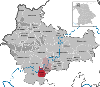
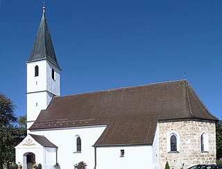
Fuchsstadt is a municipality in the district of Bad Kissingen in Bavaria in Germany.

Geroda, Lower Franconia Place in Bavaria, Germany

Geroda is a municipality in the district of Bad Kissingen in Bavaria in Germany.

Nüdlingen Place in Bavaria, Germany

Nüdlingen is a municipality in the district of Bad Kissingen in Bavaria in Germany.

Oberleichtersbach Place in Bavaria, Germany

Oberleichtersbach is a municipality in the district of Bad Kissingen in Bavaria in Germany.

Oberthulba Place in Bavaria, Germany

Oberthulba is a municipality in the district of Bad Kissingen in Bavaria in Germany.

Altendorf, Upper Franconia Place in Bavaria, Germany

Altendorf is a community in the Upper Franconian district of Bamberg, Bavaria, Germany.

Gundelsheim, Bavaria Place in Bavaria, Germany

Gundelsheim is a community in the Upper Franconian district of Bamberg.

Emmering, Ebersberg Place in Bavaria, Germany

Emmering is a community in the Upper Bavarian district of Ebersberg. It is a member of the administrative community (Verwaltungsgemeinschaft) of Aßling.

Kunreuth Place in Bavaria, Germany

Kunreuth is a municipality in the district of Forchheim in Bavaria in Germany.

Pinzberg Place in Bavaria, Germany

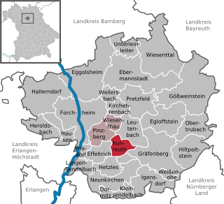
Pinzberg is a municipality in the district of Forchheim in Bavaria in Germany.

Pretzfeld Place in Bavaria, Germany

Pretzfeld is a municipality in the district of Forchheim in Bavaria in Germany.

Eching am Ammersee Place in Bavaria, Germany

Eching am Ammersee is a municipality in the district of Landsberg in Bavaria in Germany. It has a size of 6.15km2.

Bodolz Place in Bavaria, Germany

Bodolz is a municipality in the district of Lindau in Bavaria in Germany.

Weiherhammer Place in Bavaria, Germany

Weiherhammer is a municipality in the district of Neustadt an der Waldnaab in Bavaria, Germany.

Zeilarn Place in Bavaria, Germany

Zeilarn is a municipality in the district of Rottal-Inn in Bavaria, Germany.

Tacherting Place in Bavaria, Germany

Tacherting is a municipality in the north of the district of Traunstein in Bavaria, Germany.

References

  1. Liste der ersten Bürgermeister/Oberbürgermeister in kreisangehörigen Gemeinden, Bayerisches Landesamt für Statistik, 15 July 2021.
  2. "Tabellenblatt "Daten 2", Statistischer Bericht A1200C 202041 Einwohnerzahlen der Gemeinden, Kreise und Regierungsbezirke". Bayerisches Landesamt für Statistik und Datenverarbeitung (in German). June 2021.