
Mantel is a municipality located in the district of Neustadt an der Waldnaab in Bavaria, Germany. It is known as a Markt, a town that was historically granted 'market rights'. The town was first mentioned in official documents in 1212, and in 1945 it was incorporated into the municipality of Rupprechtsreuth. As part of the regional reform in Bavaria, parts of the dissolved municipality of Hütten were added to it in 1972. The town's population fell by 77 people, 2.8%, to 2728 between 1988 and 2018. Mantel is best known for its nature preserve, Naturwaldreservat Gscheibte Loh, as well as its castle, Schloss Steinfels.

Bischofsheim in der Rhön is a town in the district Rhön-Grabfeld, in Bavaria, Germany. It is situated in the Rhön Mountains, 29 km southeast of Fulda.

Kupferberg is a municipality in the district of Kulmbach, in Bavaria, Germany. It is situated in the Frankenwald, 9 km northeast of Kulmbach.

Sondheim vor der Rhön is a municipality in the district Rhön-Grabfeld, Bavaria, Germany. It is administrated by the Verwaltungsgemeinschaft Ostheim. As of 2002 it had a population of 1123, and covers an area of 18.58 km².

Elfershausen is a municipality in the district of Bad Kissingen in Bavaria in Germany.

Euerdorf is a municipality in the district of Bad Kissingen in Bavaria in Germany.
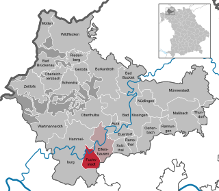
Fuchsstadt is a municipality in the district of Bad Kissingen in Bavaria in Germany.

Geroda is a municipality in the district of Bad Kissingen in Bavaria in Germany.

Motten is a municipality in the district of Bad Kissingen in Bavaria in Germany.

Nüdlingen is a municipality in the district of Bad Kissingen in Bavaria in Germany.

Oberthulba is a municipality in the district of Bad Kissingen in Bavaria in Germany.

Emmering is a community in the Upper Bavarian district of Ebersberg. It is a member of the administrative community (Verwaltungsgemeinschaft) of Aßling.

Aidhausen is a municipality in the district of Haßberge in Bavaria in Germany, it is a member of the Verwaltungsgemeinschaft Hofheim in Unterfranken.

Konradsreuth is a municipality in Upper Franconia in the district of Hof in Bavaria in Germany.

Aiglsbach is a town and municipality in the Lower Bavarian district of Kelheim, Germany, and a member of the Mainburg administrative partnership, a voluntary resource-pooling agreement with three neighbouring municipalities.

Ebensfeld is a municipality in the district of Lichtenfels in Bavaria in Germany. It lies on the river Main.
Kreuth is a municipality in the district of Miesbach in Bavaria in Germany.

Schlammersdorf is a municipality in the district of Neustadt an der Waldnaab in Bavaria, Germany.
Breitenberg is a municipality in the district of Passau in Bavaria in Germany. It lies on the border with Austria, and is the easternmost municipality of Bavaria.

Pfaffenhausen is a municipality in the district of Unterallgäu in Bavaria, Germany. The town is seat of a municipal association with Breitenbrunn, Swabia, Oberrieden, Bavaria and Salgen.


