Brachttal

Last updated
Brachttal
Wappen Brachttal.svg
Location of Brachttal within Main-Kinzig-Kreis district
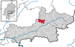
Brachttal in MKK.svgSchöneckRodenbachNeubergRonneburg
Germany adm location map.svg
Red pog.svg
Brachttal
Hesse location map.svg
Red pog.svg
Brachttal
Coordinates: 50°18′12″N9°17′52″E / 50.30333°N 9.29778°E / 50.30333; 9.29778
Country Germany
State Hesse
Admin. region Darmstadt
District Main-Kinzig-Kreis
Subdivisions6 districts
Government
   Mayor (202228) Wolfram Zimmer [1]
Area
  Total
30.85 km2 (11.91 sq mi)
Highest elevation
315 m (1,033 ft)
Lowest elevation
157 m (515 ft)
Population
 (2022-12-31) [2]
  Total
5,089
  Density160/km2 (430/sq mi)
Time zone UTC+01:00 (CET)
  Summer (DST) UTC+02:00 (CEST)
Postal codes
63636
Dialling codes 06053 and 06054
Vehicle registration MKK
Website www.gemeinde-brachttal.de

Brachttal is a municipality in the Main-Kinzig district, in Frankfurt Rhine-Main in Hesse, Germany.

Contents

Districts

The Bracht, a tributary of the Kinzig, flows through the Tal (valley) so the municipality got the name Brachttal.

Brachttal consists of six parts:

Schlierbach is the biggest part of Brachttal and also the most populous. The administration and the tourist information of Brachttal (Gemeindeverwaltung Brachttal) are located in Schlierbach.

Schlierbach is well known for its ceramic manufacture, the Waechtersbach ceramics . Next to the manufacture there is a tegut-market, the only supermarket in Brachttal.

In Spielberg and Streitberg there are ceramic museums. In Neuenschmidten is Schloss Eisenhammer and an old big oak with a scope of 7.88 meters (25.853 ft) in 2014. [3] Today the Schloss is empty.

The famous Vogelsberger Südbahnradweg leads through Schlierbach and Hellstein. This cycle track is built on a closed railway, the Vogelsberger Südbahn which was a rail connection between Wächtersbach and Hartmannshain.

There is a buslinie to Schlierbach which starts at Wächtersbach station. The bus stop Schlierbach Rathaus is in front of the administration (Gemeindeverwaltung Brachttal). More information is available by the Rhein-Main-Verkehrsverbund.

Politics

Sister cities

Coordinates/Maps of POI

References

  1. "Ergebnisse der jeweils letzten Direktwahl von Landrätinnen und Landräte sowie (Ober-)Bürgermeisterinnen und (Ober-)Bürgermeister in Hessen, Stand 13.04.2023" (XLS) (in German). Hessisches Statistisches Landesamt.
  2. "Bevölkerung in Hessen am 31.12.2022 nach Gemeinden" (XLS) (in German). Hessisches Statistisches Landesamt. June 2023.
  3. "Neuenschmidten - Eine Auflistung der Monumentalsten Eichen in Deutschland. Mit Messwerten zu den einzelnen Eichen und weiteren Informationen". www.monumentale-eichen.de (in German). Retrieved 2017-01-23.