Grebenhain

Last updated
Grebenhain
Wappen Grebenhain.png
Location of Grebenhain within Vogelsbergkreis district
Mittelhessen Vogelsberg Gre.pngSchlitzGemündenSchwalmtalLauterbachWartenbergLautertal
Germany adm location map.svg
Red pog.svg
Grebenhain
Hesse location map.svg
Red pog.svg
Grebenhain
Coordinates: 50°29′N09°21′E / 50.483°N 9.350°E / 50.483; 9.350 Coordinates: 50°29′N09°21′E / 50.483°N 9.350°E / 50.483; 9.350
Country Germany
State Hesse
Admin. region Gießen
District Vogelsbergkreis
Government
   Mayor (201925) Sebastian Stang [1]
Area
  Total91.62 km2 (35.37 sq mi)
Elevation
467 m (1,532 ft)
Population
 (2020-12-31) [2]
  Total4,629
  Density51/km2 (130/sq mi)
Time zone UTC+01:00 (CET)
  Summer (DST) UTC+02:00 (CEST)
Postal codes
36355
Dialling codes 06644, 06643, 06668
Vehicle registration VB
Website www.gemeinde-grebenhain.de

Grebenhain is a municipality in the Vogelsbergkreis in Hesse, Germany.

Contents

Geography

Location

The municipality of Grebenhain lies from 400 to 733 m above sea level in the southeastern Vogelsberg Mountains, about 30 km west of Fulda.

Neighbouring communities

Grebenhain borders in the north on the town of Herbstein, in the east on the community of Hosenfeld (Fulda district), in the south on the communities of Freiensteinau and Birstein (Main-Kinzig-Kreis), in the southwest on the town of Gedern (Wetteraukreis), and in the west on the town of Schotten.

Constituent communities

The municipality consists of 15 centres named Bannerod, Bermuthshain, Crainfeld, Grebenhain (administrative seat), Hartmannshain, Heisters, Herchenhain, Ilbeshausen-Hochwaldhausen, Metzlos, Metzlos-Gehaag, Nösberts-Weidmoos, Vaitshain, Volkartshain, Wünschen-Moos und Zahmen.

History

The area nowadays occupied by the greater community of Grebenhain in the Vogelsberg was likely settled by waves of settlers from the Wetterau between the eighth and eleventh centuries as part of the expansion carried out in the High Middle Ages by the Abbots of Fulda.

The oldest place in today's municipal area is Crainfeld, which was alluded to as early as the ninth century in a Fulda donation announcement. The first definite and verifiable mention of Crainfeld, however, is in a king's document from 1012, which also mentions Bermuthshain and Ilbeshausen in a document for the first time.

Crainfeld advantageously lay at the crossroads of two important mediaeval trade roads, and was moreover until 1821 the seat of a court district, witnessed even today by the Edelhof, the Amt building used by the Oberschultheißen (roughly "sheriffs") when the Landgraves held sway in Hesse. The stately half-timbered house was built in 1685 by carpenter Hans Muth from Ilbeshausen. Hans Muth also built the Hansenmühle (or "Teufelsmühle" – "Devil's Mill") in Ilbeshausen in 1691, one of the loveliest half-timbered buildings in Upper Hesse. Crainfeld is furthermore still the seat of the parish even today. Until the State Highway (Staatsstraße), today's Bundesstraße 275, was built in 1834-1857, and the railway line in 1901-1906 through the neighbouring community of Grebenhain, Crainfeld was the region's main town.

The communities of Crainfeld, Grebenhain, Bermuthshain and Ilbeshausen have been Hessian since 1437 and formed until 1821 the court district of Crainfeld, which belonged to the Hessian Amt of Nidda. From 1852, they belonged to the Lauterbach district. The communities of Hartmannshain and Herchenhain have likewise been Hessian since 1437 and belonged to the court district of Burkhards. Until 1938, they were part of the Schotten district. The communities of Bannerod, Heisters, Zahmen, Wünschenmoos, Vaitshain, Nösberts, Weidmoos, Metzlos-Gehaag and Metzlos belonged until 1806 to the court districts of Altenschlirf and Moos, held by the Riedesel family. When the Riedesel state was mediatized, they became Hessian. The community of Volkartshain was until 1806 owned by the Counts of Stolberg-Gedern.

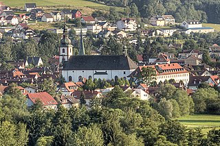
The main community of Grebenhain had its first documentary mention in a Riedesel document in 1338. Until the fifteenth century, iron ore was mined there, which is recalled today in the names Am Eisenberg (a hall) and Eisenbergsweg (a street), Eisen being German for "iron". In the west of the village, there was until 1789 a large manorial pond.

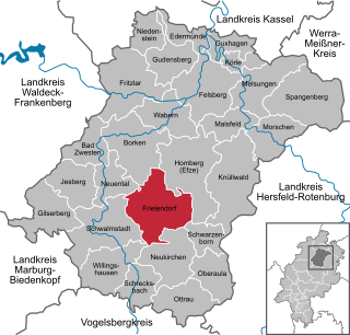
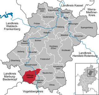
As part of Hesse's municipal reforms, the 13 formerly independent municipalities of Bannerod, Bermuthshain, Crainfeld, Grebenhain, Hartmannshain, Herchenhain, Ilbeshausen-Hochwaldhausen, Metzlos, Metzlos-Gehaag, Nösberts-Weidmoos, Steigertal (Heisters, Wünschenmoos, Zahmen), Vaitshain and Volkartshain had to merge on 1 January and 1 August 1972 into the greater community of Grebenhain.

Economy

Related Research Articles

<span class="mw-page-title-main">Kaufungen</span> Municipality in Hesse, Germany

Kaufungen is a municipality in the district of Kassel, in Hesse, Germany. It is situated in the narrow valley of the river Losse, surrounded by the steep, wooded hills of the Kaufunger Wald, approx. 10 kilometres east of Kassel.

<span class="mw-page-title-main">Bad Soden-Salmünster</span> Town in Hesse, Germany

Bad Soden-Salmünster is a town in the Main-Kinzig district, in Hesse, Germany. It is situated on the river Kinzig, between Fulda and Hanau. It has a population of around 13,000.

<span class="mw-page-title-main">Alsfeld</span> Town in Hesse, Germany

Alsfeld is a town in the center of Hesse, in Germany. Large towns nearby are Bad Hersfeld about 33 kilometres to the east, Fulda 36 kilometres to the southeast, Gießen 47 kilometres to the west and Marburg an der Lahn about 36 kilometres to the northwest. Alsfeld is located on the upper part of the Schwalm in the northern Vogelsberg and just to the south of the Knüll mountains at the western edge of the Alsfeld basin. It is well known for its well-preserved old town with hundreds of timber-frame houses, and part of the German Timber-Frame Road. In 1961, the town hosted the first Hessentag state festival, in 1985 the 25th.

<span class="mw-page-title-main">Frielendorf</span> Municipality in Hesse, Germany

Frielendorf is a municipality in the Schwalm-Eder district, Hesse, Germany.

<span class="mw-page-title-main">Malsfeld</span> Municipality in Hesse, Germany

Malsfeld is a municipality in the Schwalm-Eder district in Hesse, Germany, on the river Fulda.

<span class="mw-page-title-main">Melsungen</span> Town in Hesse, Germany

Melsungen is a small climatic spa town in the Schwalm-Eder district in northern Hesse, Germany. In 1987, the town hosted the 27th Hessentag state festival.

<span class="mw-page-title-main">Lich, Hesse</span> Town in Hesse, Germany

Lich is a town in the district of Gießen, in Hesse, Germany. It is situated 12 km southeast of Gießen. Lich has a population of around 13,000.

<span class="mw-page-title-main">Willingshausen</span> Municipality in Hesse, Germany

Willingshausen is a municipality in the Schwalm-Eder district in Hesse, Germany.

<span class="mw-page-title-main">Grebenau</span> Town in Hesse, Germany

Grebenau is a town in the Vogelsbergkreis in Hesse, Germany.

<span class="mw-page-title-main">Freiensteinau</span> Municipality in Hesse, Germany

Freiensteinau is a municipality in the Vogelsbergkreis in Hesse, Germany.

<span class="mw-page-title-main">Herbstein</span> Town in Hesse, Germany

Herbstein is a small town in the Vogelsbergkreis in Hesse, Germany.

<span class="mw-page-title-main">Schotten</span> Town in Hesse, Germany

Schotten is a town in the middle of Hesse, Germany. Larger towns nearby include Alsfeld in the north, Fulda in the east, Friedberg in the south and Gießen in the west.

<span class="mw-page-title-main">Ulrichstein</span> Town in Hesse, Germany

Ulrichstein is a small town in the Vogelsbergkreis in Hesse, Germany.

<span class="mw-page-title-main">Steinau an der Straße</span> Town in Hesse, Germany

Steinau an der Straße is a town of around 10,000 inhabitants in the Main-Kinzig district, in Hesse, Germany. It is situated on the river Kinzig, 32 kilometres (20 mi) southwest of Fulda. The name Steinau refers to stones in the river; an der Straße, meaning on the road, refers to the historic trade route Via Regia from Leipzig to Frankfurt on which it was located. Steinau is best known for the Brothers Grimm who spent part of their childhood here.

<span class="mw-page-title-main">Laubach</span> Town in Hesse, Germany

Laubach is a town of approximately 10,000 people in the Gießen region of Hesse, Germany. Laubach is known as a Luftkurort, a climatic health resort. It is situated 23 kilometres (14 mi) east of Gießen. Surrounding Laubach are the towns of Hungen, Grünberg, Schotten and Lich.

<span class="mw-page-title-main">Gedern</span> Town in Hesse, Germany

Gedern is a town in the Wetteraukreis district in Hesse, Germany, and historically belongs to Oberhessen. It is located 38 kilometres (24 mi) northeast of Hanau at the foot of the Vogelsberg, one of the largest inactive volcanoes in Europe.

<span class="mw-page-title-main">Hauneck</span> Municipality in Hesse, Germany

Hauneck is a community in Hersfeld-Rotenburg district in eastern Hesse, Germany.

<span class="mw-page-title-main">Hohenroda</span> Municipality in Hesse, Germany

Hohenroda is a municipality in Hersfeld-Rotenburg district in eastern Hesse, Germany lying right on the boundary with Thuringia.

<span class="mw-page-title-main">Lauterbach, Hesse</span> Town in Hesse, Germany

Lauterbach is a town in the Vogelsbergkreis district of the federal state of Hesse in central Germany. In 1983, the town hosted the 23rd Hessentag state festival.

<span class="mw-page-title-main">Buchenau (Eiterfeld)</span> Ortsteil of Eiterfeld in Hesse, Germany

Buchenau is a district of the market town Eiterfeld in the district of Fulda and has around 350 inhabitants.

References

  1. "Ergebnisse der letzten Direktwahl aller hessischen Landkreise und Gemeinden" (XLS) (in German). Hessisches Statistisches Landesamt. 5 September 2022.
  2. "Bevölkerung in Hessen am 31.12.2020 nach Gemeinden". Hessisches Statistisches Landesamt (in German). June 2021.