Schlitz, Hesse

Last updated
Schlitz
Stadt schlitz 01.jpg
Schlitz
Wappen Schlitz.svg
Location of Schlitz within Vogelsbergkreis district
Mittelhessen Vogelsberg Sli.pngSchlitzGemündenSchwalmtalLauterbachWartenbergLautertal
Germany adm location map.svg
Red pog.svg
Schlitz
Hesse location map.svg
Red pog.svg
Schlitz
Coordinates: 50°40′N9°34′E / 50.667°N 9.567°E / 50.667; 9.567 Coordinates: 50°40′N9°34′E / 50.667°N 9.567°E / 50.667; 9.567
Country Germany
State Hesse
Admin. region Gießen
District Vogelsbergkreis
Subdivisions17 Stadtteile
Government
   Mayor (202228) Heiko Siemon [1] (CDU)
Area
  Total142.09 km2 (54.86 sq mi)
Elevation
245 m (804 ft)
Population
 (2021-12-31) [2]
  Total9,726
  Density68/km2 (180/sq mi)
Time zone UTC+01:00 (CET)
  Summer (DST) UTC+02:00 (CEST)
Postal codes
36110
Dialling codes 06642
Vehicle registration VB
Website www.schlitz.de
Lordship (Imperial Barony, County) of Schlitz
Herrschaft (Reichsfreiherrschaft, Grafschaft) Schlitz genannt von Görtz
 
1116–1806
Status State of the Holy Roman Empire
CapitalSchlitz
GovernmentPrincipality
Historical era Middle Ages
 Established, as Fuldan fief
1116
 Acquired Ld Pfarrstellen
1563
 Gained Reichsfreiheit
1656
 Raised to Imperial barony
1677
 Raised to county
1726
  Mediatised to Hesse
1806
Preceded by
Succeeded by
Wappen Fulda.svg Fulda Abbey
Grand Duchy of Hesse Flagge Grossherzogtum Hessen ohne Wappen.svg

Schlitz is a small town in the Vogelsbergkreis in eastern Hesse, Germany.

Contents

Geography

Location

The town of Schlitz lies at the outlet of the small river Schlitz on the Fulda.

Neighbouring communities

Schlitz borders in the north on the communities of Breitenbach and Niederaula (both in Hersfeld-Rotenburg), in the east on the communities of Haunetal (Hersfeld-Rotenburg) and Burghaun and the town of Hünfeld (both in Fulda district), in the southeast on the city of Fulda (Fulda district), in the south on the communities of Großenlüder and Bad Salzschlirf (both in Fulda district), in the southwest on the community of Wartenberg, and in the west on the town of Lauterbach.

Constituent communities

Schlitz is divided into the following communities: Bernshausen, Fraurombach, Hartershausen, Hemmen, Hutzdorf, Nieder-Stoll, Ober-Wegfurth, Pfordt, Queck, Rimbach, Sandlofs, Schlitz, Üllershausen, Ützhausen, Unter-Schwarz, Unter-Wegfurth and Willofs.

History

The name Schlitz had its first documentary mention in 812. Schlitz is known throughout Hesse for the town's five castles and is also called the Romantische Burgenstadt Schlitz (the Romantic Castle Town of Schlitz).

One peculiarity about the town is its so-called Burgenring, or Castle Ring, with the town built on a hill with its accumulated castles, towers, lords' houses, the town church and many half-timbered houses presenting a well preserved, compact, historic Old Town. For the Castle Ring's splendour and the town's outstanding location, Schlitz was sometimes called in earlier times the "Hessian Rothenburg ob der Tauber"

The Lords of Schlitz had built up their mastery in an autonomous fief from the Fulda Abbey. As of 1404 they were calling themselves Schlitz von Görtz (in documents also Gurz or Görz). After the Reformation came in 1563, and as a result of the Thirty Years' War, however, they broke away from Fulda. In 1677, they became Imperial Barons and, in 1726, Imperial Counts. In 1806, the area passed to Hesse-Darmstadt.

Schlitz was granted town rights in the early 15th century.

Since 1951, the Fluß-Station Schlitz ("Schlitz River Station") has been in Schlitz. This working group from the Max Planck Institute for Limnology is researching the ecology of the tiny Breitenbach stream in the neighbouring Breitecke Nature Preserve. The Breitenbach, through many studies and publications, is one of the world's best researched and documented streams. In 2006, this research station, with the current scientific leader's retirement, is to be closed by the Max Planck Society.

Politics

Local council

Elections were held in March 2016:

The council has 31 members:

Coat of arms

Schlitz's civic coat of arms might heraldically be described thus: In argent a fess sable, within, an inescutcheon, in argent bendlets sinister embattled three points each sable.

The oldest town seal dates only from the 17th century. The current arms were conferred in 1919. The embattled bendlets in the inescutcheon stand for the town's castles. [3]

Twinned towns

Economy

Transport

Schlitz can be reached by long-distance travel by Autobahn A 7 (Hünfeld/Schlitz interchange). Nearby lie the towns of Fulda and Lauterbach.

Public institutions

Educational institutions

Schlitz is home to the Hessische Akademie für musisch-kulturelle Bildung GmbH ("Hessian Academy for Artistic-Cultural Education, Limited"), the state music academy, at Hallenburg Castle.

Regular events

Personalities

Sons and daughters of the town

In fiction

The fictional town of Schewenborn, where the plot of the 1983 novel The Last Children of Schewenborn (German : Die letzten Kinder von Schewenborn) takes place (depicting life in Germany in the aftermath of a nuclear war) is modeled on Schlitz, as specifically stated by the writer Gudrun Pausewang, herself an inhabitant of the town.

See also

Related Research Articles

The Fulda District is a Kreis (district) in the north-east of Hesse, Germany. Neighboring districts are Hersfeld-Rotenburg, Wartburgkreis, Schmalkalden-Meiningen, Rhön-Grabfeld, Bad Kissingen, Main-Kinzig, Vogelsbergkreis.

The Vogelsbergkreis is a Kreis (district) in the middle of Hesse, Germany. Neighbouring districts are Schwalm-Eder, Hersfeld-Rotenburg, Fulda, Main-Kinzig, Wetteraukreis, Gießen and Marburg-Biedenkopf.

Hersfeld-Rotenburg is a Kreis (district) in the east of Hesse, Germany. Neighboring districts are Werra-Meißner, Wartburgkreis, Fulda, Vogelsbergkreis, Schwalm-Eder.

<span class="mw-page-title-main">Bebra</span> Town in Hesse, Germany

Bebra is a small town in Hersfeld-Rotenburg district in northeastern Hesse, Germany.

<span class="mw-page-title-main">Hünfeld</span> Town in Hesse, Germany

Hünfeld is a town in the district of Fulda, in Hesse, Germany. It is situated 16 km northeast of Fulda. In 2000, the town hosted the 40th Hessentag state festival. Hünfeld has a population close to 16,000.

<span class="mw-page-title-main">Rotenburg an der Fulda</span> Town in Hesse, Germany

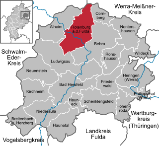
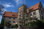
Rotenburg an der Fulda is a town in Hersfeld-Rotenburg district in northeastern Hesse, Germany lying, as the name says, on the river Fulda.

<span class="mw-page-title-main">Grebenau</span> Town in Hesse, Germany

Grebenau is a town in the Vogelsbergkreis in Hesse, Germany.

<span class="mw-page-title-main">Romrod</span> Town in Hesse, Germany

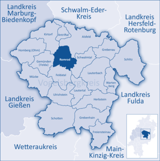
Romrod is a small town in the Vogelsbergkreis in central Hesse, Germany.

<span class="mw-page-title-main">Schenklengsfeld</span> Municipality in Hesse, Germany

Schenklengsfeld is a municipality in Hersfeld-Rotenburg district in eastern Hessen, Germany lying roughly 30 km northeast of Fulda and 60 km southeast of Kassel.

<span class="mw-page-title-main">Niederaula</span> Municipality in Hesse, Germany

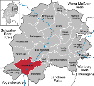
Niederaula is a market community in Hersfeld-Rotenburg district in northeastern Hesse, Germany, 59 km south of Kassel.

<span class="mw-page-title-main">Kirchheim, Hesse</span> Municipality in Hesse, Germany

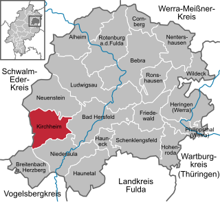
Kirchheim is a municipality in Hersfeld-Rotenburg district in northeastern Hesse, Germany.

<span class="mw-page-title-main">Breitenbach am Herzberg</span> Municipality in Hesse, Germany

Breitenbach am Herzberg is a municipality in southwesternmost Hersfeld-Rotenburg district in eastern Hesse, Germany.

<span class="mw-page-title-main">Neuenstein, Hesse</span> Municipality in Hesse, Germany

Neuenstein is a municipality in the Hersfeld-Rotenburg district of northeastern Hesse, Germany.

<span class="mw-page-title-main">Haunetal</span> Municipality in Hesse, Germany

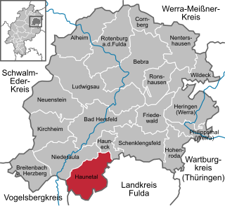
Haunetal is a municipality in Hersfeld-Rotenburg district in eastern Hesse, Germany. Haunetal is the district's southernmost municipality.

<span class="mw-page-title-main">Hohenroda</span> Municipality in Hesse, Germany

Hohenroda is a municipality in Hersfeld-Rotenburg district in eastern Hesse, Germany lying right on the boundary with Thuringia.

<span class="mw-page-title-main">Cornberg</span> Municipality in Hesse, Germany

Cornberg is a municipality in Hersfeld-Rotenburg district in northeastern Hesse, Germany. It is the district's smallest municipality.

<span class="mw-page-title-main">Friedewald, Hesse</span> Municipality in Hesse, Germany

Friedewald is a municipality in Hersfeld-Rotenburg district in eastern Hesse, Germany, directly east of Bad Hersfeld.

<span class="mw-page-title-main">Ludwigsau</span> Municipality in Hesse, Germany

Ludwigsau is a municipality in Hersfeld-Rotenburg district in northeastern Hesse, Germany. With an area of 112 km² it is Hesse's biggest community by land area.

<span class="mw-page-title-main">Nentershausen, Hesse</span> Municipality in Hesse, Germany

Nentershausen is a municipality in Hersfeld-Rotenburg district in northeastern Hesse, Germany.

<span class="mw-page-title-main">Lauterbach, Hesse</span> Town in Hesse, Germany

Lauterbach is a town in the Vogelsbergkreis district of the federal state of Hesse in central Germany. In 1983, the town hosted the 23rd Hessentag state festival.

References

  1. "Ergebnisse der letzten Direktwahl aller hessischen Landkreise und Gemeinden" (XLS) (in German). Hessisches Statistisches Landesamt. 5 September 2022.
  2. "Die Bevölkerung der hessischen Gemeinden am 31. Dezember 2021" (PDF) (in German). Hessisches Statistisches Landesamt. June 2022.
  3. "Deutsche Wappen (Gemeindewappen Kreiswappen) - German Civic Heraldry-SCHLITZ". Archived from the original on 2001-07-30.