Breitenbach am Herzberg

Last updated
Breitenbach am Herzberg
Wappen Breitenbach am Herzberg.png
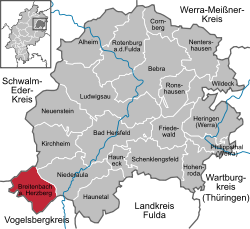
Location of Breitenbach am Herzberg within Hersfeld-Rotenburg district
Breitenbach a. Herzberg in HEF.svgNentershausenPhilippsthalFriedewaldNeuensteinKirchheim
Germany adm location map.svg
Red pog.svg
Breitenbach am Herzberg
Hesse location map.svg
Red pog.svg
Breitenbach am Herzberg
Coordinates: 50°46′N09°31′E / 50.767°N 9.517°E / 50.767; 9.517 Coordinates: 50°46′N09°31′E / 50.767°N 9.517°E / 50.767; 9.517
Country Germany
State Hesse
Admin. region Kassel
District Hersfeld-Rotenburg
Subdivisions5 districts
Government
   Mayor (202026) Volker Jaritz [1]
Area
  Total42.14 km2 (16.27 sq mi)
Elevation
257 m (843 ft)
Population
 (2020-12-31) [2]
  Total1,664
  Density39/km2 (100/sq mi)
Time zone UTC+01:00 (CET)
  Summer (DST) UTC+02:00 (CEST)
Postal codes
36287
Dialling codes 06675
Vehicle registration HEF
Website www.breitenbach-am-herzberg.de

Breitenbach am Herzberg (officially Breitenbach a. Herzberg) is a municipality in southwesternmost Hersfeld-Rotenburg district in eastern Hesse, Germany.

Contents

Geography

Rimberg seen from the castle Rimberg knuellgebirge.jpg
Rimberg seen from the castle

Location

The community lies at the foot of the Hirschberg (often also known as the Herzberg) and the Rimberg in the southern Knüllgebirge (range). The constituent communities are scattered through the Jossa valley and its side valleys.

The municipal area’s lowest point is to be found on the Jossa in the constituent community of Oberjossa and lies 234 m above sea level. Its highest point lies 529 m above sea level on the slopes of the Rimberg.

The community lies between Alsfeld (some 18 km to the west) and Bad Hersfeld (some 20 km to the northeast).

Neighbouring communities

Breitenbach borders in the north on the communities of Ottrau and Oberaula (both in the Schwalm-Eder-Kreis), in the east on the communities of Kirchheim and Niederaula (both in Hersfeld-Rotenburg), in the south on the towns of Schlitz and Grebenau and in the west on the town of Alsfeld (all three in the Vogelsbergkreis).

Constituent communities

Breitenbach’s Ortsteile are Breitenbach, Hatterode, Oberjossa, Gehau and Machtlos.

Goods train at the end of the Grundchenbahn Mini-CIMG1394.JPG
Goods train at the end of the Gründchenbahn

History

In 1290, Breydenbach apud stratam bi dem Herzisberg had its first documentary mention. The document itself deals, however, with other, older documents, leading to the supposition that the villages arose as early as some time between 400 and 800.

From 1290 to 1298, Herzberg Castle was built on the trade road Kurze Hessen by Heinrich von Romrod. Heinrich acquired the area around the village as a fief from the Landgraves of Hesse.

In 1372 and 1373, the castle was a main stronghold under Friedrich von Herzberg of the Sternerbund, a knightly order that in the last fourth of the 14th century was fighting against the growing power of the Landgraves of Hesse. Over several hundred years thereafter, the castle and later state fort of Herzberg was held by the Barons of Dörnberg.

Amalgamations

With effect from 31 December 1971, the communities of Breitenbach, Hatterode and Oberjossa willingly merged, founding the new greater community of Breitenbach am Herzberg. The centres of Gehau and Machtlos joined them in the course of municipal reform on 1 July 1972.

Politics

Community council

The municipal election held on 26 March 2006 yielded the following results:

Parties and voter communities%
2006
Seats
2006
%
2001
Seats
2001
SPD Social Democratic Party of Germany 50.7853.98
FWGFreie Wählergemeinschaft Breitenbach a. H.49.3746.17
Total100.015100.015
Voter turnout in %61.862.1

The community’s executive (Gemeindevorstand) is made up of five members, with three seats allotted to the SPD and 1 to the FWG.

Mayors

Volker Jaritz was elected mayor in a runoff election on 10 February 2008 with 65.5% of the vote. He succeeded Siegfried Steube (FWG), who had been elected on 27 January 2002 with 71.7% of the vote. Before him came Paul Orth (SPD), who was elected on 3 March 1996 with 70.8% of the vote.

Coat of arms

The community’s arms might be described thus: Bendy wavy sinister argent and azure a crenellated tower party per bend gules and Or royally crowned, thereover a mullet of six counterchanged.

The tower stands for Herzberg Castle. The mullet of six (six-pointed star) recalls the knightly order of the Sternerbund (Stern is German for “star”), who had an important stronghold in the castle. The tinctures gold and red come from the arms borne by the Barons of Dörnberg, who held the castle beginning in 1477.

Burg Herzberg Burg herzberg komandanten.jpg
Burg Herzberg
Castle chapel and keep ruins, both built about 1290 Burg herzberg bergfried.jpg
Castle chapel and keep ruins, both built about 1290

Culture and sightseeing

Buildings

Regular events

Related Research Articles

The Vogelsbergkreis is a Kreis (district) in the middle of Hesse, Germany. Neighbouring districts are Schwalm-Eder, Hersfeld-Rotenburg, Fulda, Main-Kinzig, Wetteraukreis, Gießen and Marburg-Biedenkopf.

<span class="mw-page-title-main">Oberaula</span> Municipality in Hesse, Germany

Oberaula is a municipality in the Schwalm-Eder district in Hesse, Germany.

<span class="mw-page-title-main">Ottrau</span> Municipality in Hesse, Germany

Ottrau is a municipality in the Schwalm-Eder-Kreis in Hesse, Germany.

<span class="mw-page-title-main">Grebenau</span> Town in Hesse, Germany

Grebenau is a town in the Vogelsbergkreis in Hesse, Germany.

<span class="mw-page-title-main">Antrifttal</span> Municipality in Hesse, Germany

Antrifttal is a municipality in the Vogelsbergkreis in Hesse, Germany.

<span class="mw-page-title-main">Kirtorf</span> Town in Hesse, Germany

Kirtorf is a town in the northern Vogelsbergkreis in Hesse, Germany. Through the town runs the Deutsche Märchenstraße, or German Fairytale Road, a touristic route joining many of the places commonly associated with the Brothers Grimm's tales.

<span class="mw-page-title-main">Romrod</span> Town in Hesse, Germany

Romrod is a small town in the Vogelsbergkreis in central Hesse, Germany.

<span class="mw-page-title-main">Schlitz, Hesse</span> Town in Hesse, Germany

Schlitz is a small town in the Vogelsbergkreis in eastern Hesse, Germany.

<span class="mw-page-title-main">Schwalmtal, Hesse</span> Municipality in Hesse, Germany

Schwalmtal is a community in the Vogelsbergkreis in Hesse, Germany.

<span class="mw-page-title-main">Waldkappel</span> Town in Hesse, Germany

Waldkappel is a small town in the Werra-Meißner-Kreis district in northern Hesse, Germany.

<span class="mw-page-title-main">Philippsthal (Werra)</span> Municipality in Hesse, Germany

Philippsthal (Werra) is a market community in Hersfeld-Rotenburg district in eastern Hesse, Germany, right at the boundary with Thuringia.

<span class="mw-page-title-main">Wildeck</span> Municipality in Hesse, Germany

Wildeck is a municipality in Hersfeld-Rotenburg district in northeastern Hesse, Germany lying right at the boundary with Thuringia, 54 km southeast of Kassel.

<span class="mw-page-title-main">Niederaula</span> Municipality in Hesse, Germany

Niederaula is a market community in Hersfeld-Rotenburg district in northeastern Hesse, Germany, 59 km south of Kassel.

<span class="mw-page-title-main">Kirchheim, Hesse</span> Municipality in Hesse, Germany

Kirchheim is a community in Hersfeld-Rotenburg district in northeastern Hesse, Germany.

<span class="mw-page-title-main">Neuenstein, Hesse</span> Municipality in Hesse, Germany

Neuenstein is a community in Hersfeld-Rotenburg district in northeastern Hesse, Germany.

<span class="mw-page-title-main">Haunetal</span> Municipality in Hesse, Germany

Haunetal is a municipality in Hersfeld-Rotenburg district in eastern Hesse, Germany. Haunetal is the district's southernmost municipality.

<span class="mw-page-title-main">Hauneck</span> Municipality in Hesse, Germany

Hauneck is a community in Hersfeld-Rotenburg district in eastern Hesse, Germany.

<span class="mw-page-title-main">Friedewald, Hesse</span> Municipality in Hesse, Germany

Friedewald is a municipality in Hersfeld-Rotenburg district in eastern Hesse, Germany, directly east of Bad Hersfeld.

<span class="mw-page-title-main">Ludwigsau</span> Municipality in Hesse, Germany

Ludwigsau is a community in Hersfeld-Rotenburg district in northeastern Hesse, Germany. With an area of 112 km² it is Hesse's biggest community by land area.

<span class="mw-page-title-main">Ronshausen</span> Municipality in Hesse, Germany

Ronshausen is a community and a Luftkurort in Hersfeld-Rotenburg district in northeastern Hesse, Germany.

References

  1. "Ergebnisse der letzten Direktwahl aller hessischen Landkreise und Gemeinden" (XLS) (in German). Hessisches Statistisches Landesamt. 5 September 2022.
  2. "Bevölkerung in Hessen am 31.12.2020 nach Gemeinden". Hessisches Statistisches Landesamt (in German). June 2021.