Nentershausen, Hesse

Last updated
Nentershausen
Nentershausen view.jpg
View over Nentershausen (main centre)
Wappen Nentershausen (Hessen).png
Location of Nentershausen within Hersfeld-Rotenburg district
Nentershausen in HEF.svgNentershausenPhilippsthalFriedewaldNeuensteinKirchheim
Germany adm location map.svg
Red pog.svg
Nentershausen
Hesse location map.svg
Red pog.svg
Nentershausen
Coordinates: 51°0′45″N9°56′6″E / 51.01250°N 9.93500°E / 51.01250; 9.93500
Country Germany
State Hesse
Admin. region Kassel
District Hersfeld-Rotenburg
Government
   Mayor (201824) Ralf Hilmes [1] (SPD)
Area
  Total57.06 km2 (22.03 sq mi)
Elevation
299 m (981 ft)
Population
 (2022-12-31) [2]
  Total2,529
  Density44/km2 (110/sq mi)
Time zone UTC+01:00 (CET)
  Summer (DST) UTC+02:00 (CEST)
Postal codes
36214
Dialling codes 06627
Vehicle registration HEF
Website www.nentershausen.de

Nentershausen is a municipality in Hersfeld-Rotenburg district in northeastern Hesse, Germany.

Contents

Geography

Location

The community lies in the mountains in eastern Hesse, where it finds itself in the centre of the Richelsdorfer Gebirge (range) between the Fulda to the west and the Werra to the east. The municipal area lies in the Hasel drainage basin whose namesake river empties into the river Sontra near Sontra.

The nearest major towns are Bad Hersfeld (some 25 km to the southwest), Eisenach (some 30 km to the east) and Eschwege (some 25 km to the north).

Neighbouring communities

Nentershausen borders in the north and east on the town of Sontra (in the Werra-Meißner-Kreis), in the southeast on the community of Wildeck, in the south on the community of Ronshausen and in the west on the town of Bebra and the community of Cornberg (all in Hersfeld-Rotenburg).

Constituent communities

Nentershausen's Ortsteile , besides the main centre, also called Nentershausen, are Bauhaus, Dens, Mönchhosbach, Süß and Weißenhasel.

Tannenberg Castle Tannenberg west.jpg
Tannenberg Castle

History

The first documentary mention of any of the constituent communities came from an interest register from the monastery at Helmershausen (nowadays part of the unitary community of Rhönblick), wherein Hasels is mentioned in 1120 as Hasolo in Thuringia. Tense followed in 1195 and Susse in 1267, which Hermann von Trott had acquired as a Lauterberg fief. The other places followed in the course of the 14th century.

About 1300, Ludwig I of Baumbach built Tannenberg Castle.

Amalgamations

In the course of municipal reform, the above-named communities merged into the greater community of Nentershausen on 31 December 1971.

Politics

Community council

The municipal election held on 26 March 2006 yielded the following results:

Parties and voter communities%
2006
Seats
2006
%
2001
Seats
2001
CDU Christian Democratic Union of Germany 36.5836.48
SPD Social Democratic Party of Germany 63.51563.615
Total100.023100.023
Voter turnout in %61.967.1

Mayors

The former mayor Lothar Schmidt (SPD) was elected to a fourth term on 10 September 2000 with 90.6% of the vote. He had first been elected on 17 December 1982 for a term beginning on 1 January 1983. On 3 September 2006, Ralf Hilmes (SPD) was elected with 71.7% of the vote, thereby unseating Lothar Schmidt as the mayor on 1 January 2007.

Coat of arms

The community's arms might be described thus: Party per fess embattled of six vert a chief counter-sapiné of three argent, argent a mount of three of the first, surmounted by a sledgehammer and a cross-peen hammer per saltire Or.

Although the arms shown in this article show the two tools in silver (white), the German blazon says that this charge should be gold.

The coat of arms was conferred upon the community on 4 November 1981 by the Hessian Minister of the Interior.

The fir trees in the upper part of the escutcheon refer to the community's wealth in woodland. The six battlements symbolize the six constituent communities and Tannenberg Castle. The mining tools refer to the community's historical mining. Until the mid 20th century, bituminous shale (Kupferschiefer) was mined in Nentershausen.

Town partnerships

There was once a sponsorship arrangement with 4 Company of the Armoured Reconnaissance Battalion (Panzeraufklärungsbataillon) 5 in Sontra. This came to an end on 31 December 2007 when the battalion was disbanded.

Culture and sightseeing

Church in Nentershausen Nentershausen kirche.jpg
Church in Nentershausen

Museums

Buildings

Natural monuments

In Nentershausen stands a protected village or court linden tree that is some 600 years old.

Regular events

Famous people

Sons and daughters of the town

People associated with the community

Further reading

Related Research Articles

<span class="mw-page-title-main">Heringen</span> Town in Hesse, Germany

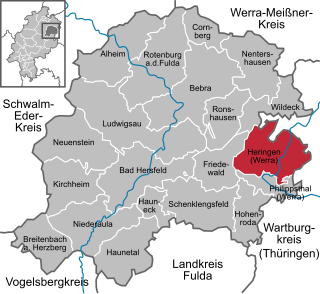
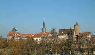
Heringen (Werra) is a small town in Hersfeld-Rotenburg district in eastern Hesse, Germany lying right at the boundary with Thuringia.

<span class="mw-page-title-main">Felsberg, Hesse</span> Town in Hesse, Germany

Felsberg is a town in the Schwalm-Eder district about 25 kilometres south of Kassel.

<span class="mw-page-title-main">Schlitz, Hesse</span> Town in Hesse, Germany

Schlitz is a small town in the Vogelsbergkreis in eastern Hesse, Germany.

<span class="mw-page-title-main">Sontra</span> Town in Hesse, Germany

Sontra is a small town in the Werra-Meißner-Kreis in northeastern Hesse, Germany.

<span class="mw-page-title-main">Waldkappel</span> Town in Hesse, Germany

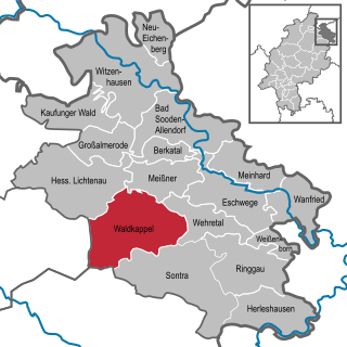
Waldkappel is a small town in the Werra-Meißner-Kreis district in northern Hesse, Germany.

<span class="mw-page-title-main">Philippsthal (Werra)</span> Municipality in Hesse, Germany

Philippsthal (Werra) is a market community in Hersfeld-Rotenburg district in eastern Hesse, Germany, right at the boundary with Thuringia.

<span class="mw-page-title-main">Schenklengsfeld</span> Municipality in Hesse, Germany

Schenklengsfeld is a municipality in Hersfeld-Rotenburg district in eastern Hessen, Germany lying roughly 30 km northeast of Fulda and 60 km southeast of Kassel.

<span class="mw-page-title-main">Ringgau</span> Municipality in Hesse, Germany

Ringgau is a municipality in the Werra-Meißner-Kreis in Hesse, Germany.

<span class="mw-page-title-main">Wehretal</span> Municipality in Hesse, Germany

Wehretal is a municipality in the Werra-Meißner-Kreis in northeastern Hesse, Germany.

<span class="mw-page-title-main">Weißenborn, Hesse</span> Municipality in Hesse, Germany

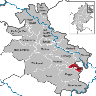
Weißenborn is a municipality in the Werra-Meißner-Kreis in Hesse, Germany.

<span class="mw-page-title-main">Alheim</span> Municipality in Hesse, Germany

Alheim is a municipality in Hersfeld-Rotenburg district in northeastern Hesse, Germany. It is named after nearby Alheimer Mountain. Alheim consist of 10 former souverain villages situated on both banks of the river Fulda.

<span class="mw-page-title-main">Wildeck</span> Municipality in Hesse, Germany

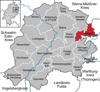
Wildeck is a municipality in Hersfeld-Rotenburg district in northeastern Hesse, Germany lying right at the boundary with Thuringia, 54 km southeast of Kassel.

<span class="mw-page-title-main">Kirchheim, Hesse</span> Municipality in Hesse, Germany

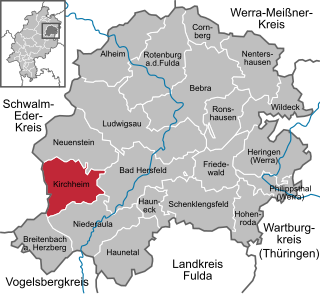
Kirchheim is a municipality in Hersfeld-Rotenburg district in northeastern Hesse, Germany.

<span class="mw-page-title-main">Breitenbach am Herzberg</span> Municipality in Hesse, Germany

Breitenbach am Herzberg is a municipality in southwesternmost Hersfeld-Rotenburg district in eastern Hesse, Germany.

<span class="mw-page-title-main">Haunetal</span> Municipality in Hesse, Germany

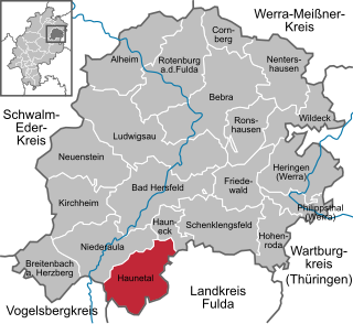
Haunetal is a municipality in Hersfeld-Rotenburg district in eastern Hesse, Germany. Haunetal is the district's southernmost municipality.

<span class="mw-page-title-main">Hauneck</span> Municipality in Hesse, Germany

Hauneck is a municipality in Hersfeld-Rotenburg district in eastern Hesse, Germany.

<span class="mw-page-title-main">Cornberg</span> Municipality in Hesse, Germany

Cornberg is a municipality in Hersfeld-Rotenburg district in northeastern Hesse, Germany. It is the district's smallest municipality.

<span class="mw-page-title-main">Friedewald, Hesse</span> Municipality in Hesse, Germany

Friedewald is a municipality in Hersfeld-Rotenburg district in eastern Hesse, Germany, directly east of Bad Hersfeld.

<span class="mw-page-title-main">Ludwigsau</span> Municipality in Hesse, Germany

Ludwigsau is a municipality in Hersfeld-Rotenburg district in northeastern Hesse, Germany. With an area of 112 km² it is Hesse's biggest community by land area.

<span class="mw-page-title-main">Ronshausen</span> Municipality in Hesse, Germany

Ronshausen is a municipality and a Luftkurort in Hersfeld-Rotenburg district in northeastern Hesse, Germany.

References