Cornberg

Last updated
Cornberg
Wappen Cornberg.png
Location of Cornberg within Hersfeld-Rotenburg district
Cornberg in HEF.svgNentershausenPhilippsthalFriedewaldNeuensteinKirchheim
Germany adm location map.svg
Red pog.svg
Cornberg
Hesse location map.svg
Red pog.svg
Cornberg
Coordinates: 51°3′N9°52′E / 51.050°N 9.867°E / 51.050; 9.867 Coordinates: 51°3′N9°52′E / 51.050°N 9.867°E / 51.050; 9.867
Country Germany
State Hesse
Admin. region Kassel
District Hersfeld-Rotenburg
Subdivisions3 districts
Government
   Mayor (202026) Katja Gonzalez Conteras [1] (Ind.)
Area
  Total23.36 km2 (9.02 sq mi)
Highest elevation
315 m (1,033 ft)
Lowest elevation
280 m (920 ft)
Population
 (2020-12-31) [2]
  Total1,348
  Density58/km2 (150/sq mi)
Time zone UTC+01:00 (CET)
  Summer (DST) UTC+02:00 (CEST)
Postal codes
36219
Dialling codes 05650
Vehicle registration HEF

Cornberg is a municipality in Hersfeld-Rotenburg district in northeastern Hesse, Germany. It is the district's smallest municipality.

Contents

Geography

View over Cornberg Cornberg.jpg
View over Cornberg

Location

The community lies between the towns of Bad Hersfeld to the south and Eschwege to the north, each 27 km away. The municipal area lies between the Stölzinger Gebirge and the Richelsdorfer Gebirge (ranges), and in the upper reaches of the Sontra, which flows through the outlying centres of Rockensüß and Königswald. Through Cornberg itself flows the brook Cornberger Wasser, which empties into the Sontra near Berneburg (a constituent community of Sontra).

Neighbouring communities

Cornberg borders in the north on the town of Waldkappel, in the east on the town of Sontra (both in the Werra-Meißner-Kreis), in the southeast on the community of Nentershausen, in the south on the town of Bebra and in the west on the town of Rotenburg an der Fulda (all three in Hersfeld-Rotenburg).

Constituent communities

Cornberg's Ortsteile are Cornberg, Königswald and Rockensüß.

History

Gothic monastery church (north wing of the cloister) with the adjoining west wing Cornberg klosterkirche aussen.jpg
Gothic monastery church (north wing of the cloister) with the adjoining west wing

The outlying centres of Rockensüß and Königswald had their first documentary mentions in 1274 and 1351 respectively. The village of Cornberg was founded only in 1938 as a mining settlement for Electoral-Hessian bituminous shale (Kupferschiefer) mining in the Richelsdorfer Gebirge. It is the only new settlement in the old Rotenburg an der Fulda district to arise since the Thirty Years' War.

There was however, from 1296, a Benedictine monastery here. It was long a provost's seat of Hersfeld Abbey. The monastery was dissolved in 1526 and converted into an agricultural estate. In 1582, Philipp Wilhelm von Cornberg, a son of William IV, Landgrave of Hesse-Kassel born out of wedlock, acquired the monastery and its lands as a fief. Philipp Wilhelm sold it in 1598 to his half-brother Maurice, Landgrave of Hesse-Kassel, who transferred it in 1627 to the so-called Rotenburger Quart. It became a Vogtei that remained in the ownership of the Landgraves of Hesse-Rotenburg until they died out in 1834, whereupon it passed back to the Electorate of Hesse. Until 1964, the former monastery was a state domain of the Land of Hesse. The trade and dwelling buildings around the monastery, which by this time were falling into ruins, were all torn down between 1957 and 1973. Only the Gothic cloister is preserved. Between 1990 and 1994 it was restored. The former two-naved church (the cloister's north wing) with the still preserved nuns’ gallery is used today as a cultural stage. Two other wings house the community centre and the museum. In the east wing is found a gastronomical business.

From 1945 to 1949, the whole community of Cornberg and the monastery were a UNRRA displaced persons camp mainly for people from the Soviet Union and Poland who were conscripted as forced labourers during WWII. Many of them emigrated from here to Canada and the United States. While living in Cornberg, these displaced persons lived in barracks-style accommodations, often many families to one room while they waited for final emigration clearance to their eventual homes overseas.

Politics

Community council

The municipal election held on 26 March 2006 yielded the following results:

Parties and voter communities%
2006
Seats
2006
%
2001
Seats
2001
CDU Christian Democratic Union of Germany 15.0215.52
SPD Social Democratic Party of Germany 61.0945.07
CBLCornberger Bürger Liste24.0439.56
Total100.015100.015
Voter turnout in %50.763.4

Mayor

Coat of arms

The community's arms might be described thus: Party per fess, argent a lion passant gules, chequy of five gules and argent.

The community's arms are borrowed from the family arms borne by the Barons of Cornberg, but with somewhat different tinctures. The lion passant (walking with one forepaw upraised) stands for the family's roots, which go back to the Landgraves of Hesse (Hesse's heraldic charge is a red-and-silver-striped lion rampant). The chequer pattern in the family's arms stands for a chessboard, and in those arms takes the tinctures azure, gules and argent (blue, red and silver). The coat of arms was conferred upon the community on 26 February 1981.

Amalgamations

The community of Königswald was amalgamated on 11 August 1972.

Economy and infrastructure

Transport

Through the main community of Cornberg run Bundesstraße 27 and the BebraGöttingen railway line.

Culture and sightseeing

Museums

Buildings

Related Research Articles

Hersfeld-Rotenburg is a Kreis (district) in the east of Hesse, Germany. Neighboring districts are Werra-Meißner, Wartburgkreis, Fulda, Vogelsbergkreis, Schwalm-Eder.

Schwalm-Eder-Kreis is a Kreis (district) in the north of Hesse, Germany. Neighbouring districts are Kassel, Werra-Meißner, Hersfeld-Rotenburg, Vogelsberg, Marburg-Biedenkopf, and Waldeck-Frankenberg.

<span class="mw-page-title-main">Eschwege</span> Town in Hesse, Germany

Eschwege, the district seat of the Werra-Meißner-Kreis, is a town in northeastern Hesse, Germany. In 1971, the town hosted the eleventh Hessentag state festival.

<span class="mw-page-title-main">Bebra</span> Town in Hesse, Germany

Bebra is a small town in Hersfeld-Rotenburg district in northeastern Hesse, Germany.

<span class="mw-page-title-main">Schwalmstadt</span> Town in Hesse, Germany

Schwalmstadt is the largest town in the Schwalm-Eder district, in northern Hesse, Germany. It was established only in 1970 with the amalgamation of the towns of Treysa and Ziegenhain together with some outlying villages to form the town of Schwalmstadt.

<span class="mw-page-title-main">Melsungen</span> Town in Hesse, Germany

Melsungen is a small climatic spa town in the Schwalm-Eder district in northern Hesse, Germany. In 1987, the town hosted the 27th Hessentag state festival.

<span class="mw-page-title-main">Rotenburg an der Fulda</span> Town in Hesse, Germany

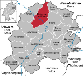
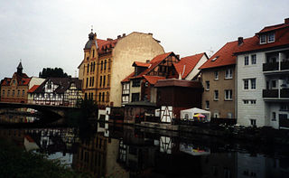
Rotenburg an der Fulda is a town in Hersfeld-Rotenburg district in northeastern Hesse, Germany lying, as the name says, on the river Fulda.

<span class="mw-page-title-main">Sontra</span> Town in Hesse, Germany

Sontra is a small town in the Werra-Meißner-Kreis in northeastern Hesse, Germany.

<span class="mw-page-title-main">Waldkappel</span> Town in Hesse, Germany

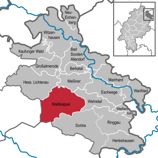
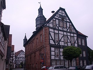
Waldkappel is a small town in the Werra-Meißner-Kreis district in northern Hesse, Germany.

<span class="mw-page-title-main">Philippsthal (Werra)</span> Municipality in Hesse, Germany

Philippsthal (Werra) is a market community in Hersfeld-Rotenburg district in eastern Hesse, Germany, right at the boundary with Thuringia.

<span class="mw-page-title-main">Wildeck</span> Municipality in Hesse, Germany

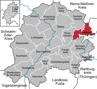
Wildeck is a municipality in Hersfeld-Rotenburg district in northeastern Hesse, Germany lying right at the boundary with Thuringia, 54 km southeast of Kassel.

<span class="mw-page-title-main">Niederaula</span> Municipality in Hesse, Germany

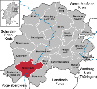
Niederaula is a market community in Hersfeld-Rotenburg district in northeastern Hesse, Germany, 59 km south of Kassel.

<span class="mw-page-title-main">Breitenbach am Herzberg</span> Municipality in Hesse, Germany

Breitenbach am Herzberg is a municipality in southwesternmost Hersfeld-Rotenburg district in eastern Hesse, Germany.

<span class="mw-page-title-main">Neuenstein, Hesse</span> Municipality in Hesse, Germany

Neuenstein is a community in Hersfeld-Rotenburg district in northeastern Hesse, Germany.

<span class="mw-page-title-main">Hauneck</span> Municipality in Hesse, Germany

Hauneck is a community in Hersfeld-Rotenburg district in eastern Hesse, Germany.

<span class="mw-page-title-main">Hohenroda</span> Municipality in Hesse, Germany

Hohenroda is a municipality in Hersfeld-Rotenburg district in eastern Hesse, Germany lying right on the boundary with Thuringia.

<span class="mw-page-title-main">Friedewald, Hesse</span> Municipality in Hesse, Germany

Friedewald is a municipality in Hersfeld-Rotenburg district in eastern Hesse, Germany, directly east of Bad Hersfeld.

<span class="mw-page-title-main">Ludwigsau</span> Municipality in Hesse, Germany

Ludwigsau is a community in Hersfeld-Rotenburg district in northeastern Hesse, Germany. With an area of 112 km² it is Hesse's biggest community by land area.

<span class="mw-page-title-main">Nentershausen, Hesse</span> Municipality in Hesse, Germany

Nentershausen is a community in Hersfeld-Rotenburg district in northeastern Hesse, Germany.

<span class="mw-page-title-main">Ronshausen</span> Municipality in Hesse, Germany

Ronshausen is a community and a Luftkurort in Hersfeld-Rotenburg district in northeastern Hesse, Germany.

References

  1. "Ergebnisse der letzten Direktwahl aller hessischen Landkreise und Gemeinden" (XLS) (in German). Hessisches Statistisches Landesamt. 5 September 2022.
  2. "Bevölkerung in Hessen am 31.12.2020 nach Gemeinden". Hessisches Statistisches Landesamt (in German). June 2021.