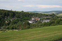
Kirchheim, Hesse

Last updated
Kirchheim
Wappen Kirchheim (Hessen).svg
Location of Kirchheim within Hersfeld-Rotenburg district
Kirchheim in HEF.svgNentershausenPhilippsthalFriedewaldNeuensteinKirchheim
Germany adm location map.svg
Red pog.svg
Kirchheim
Hesse location map.svg
Red pog.svg
Kirchheim
Coordinates: 50°50′27″N9°34′28″E / 50.84083°N 9.57444°E / 50.84083; 9.57444
Country Germany
State Hesse
Admin. region Kassel
District Hersfeld-Rotenburg
Subdivisions12 districts
Government
   Mayor (202228) Axel Schmidt [1] (CDU)
Area
  Total50.66 km2 (19.56 sq mi)
Elevation
244 m (801 ft)
Population
 (2021-12-31) [2]
  Total3,514
  Density69/km2 (180/sq mi)
Time zone UTC+01:00 (CET)
  Summer (DST) UTC+02:00 (CEST)
Postal codes
36275
Dialling codes 06625, 06628
Vehicle registration HEF
Website www.kirchheim.de

Kirchheim is a municipality in Hersfeld-Rotenburg district in northeastern Hesse, Germany.

Contents

Geography

Location

Kircheim with the A 7 and the Walsebach valley bridge in the background Kirchheim nord hessen.jpg
Kircheim with the A 7 and the Wälsebach valley bridge in the background

The community lies on the south slope of the Knüllgebirge (range) in the valley of the brook Ibra and the Aula, which empties into the Fulda near Niederaula. The local mountain is the 636 m-high Eisenberg.

The nearest major towns and cities are Bad Hersfeld (some 10 km to the east), Fulda (some 34 km (21 mi) to the south) and Alsfeld (some 24 km (15 mi) to the west). Kassel lies 54 km (34 mi) to the north.

Neighbouring communities

Kirchheim borders in the north on the community of Neuenstein, in the east on the town of Bad Hersfeld, in the south on the community of Niederaula, in the southwest on the community of Breitenbach am Herzberg (all in Hersfeld-Rotenburg) and in the west on the community of Oberaula (in the Schwalm-Eder-Kreis).

Constituent communities

Kirchheim's Ortsteile , besides the main centre, also called Kirchheim, are Allendorf, Frielingen, Gersdorf, Gershausen, Goßmannsrode, Heddersdorf, Kemmerode, Reckerode, Reimboldshausen, Rotterterode and Willingshain.

Climate

The mean yearly air temperature is 7.4 °C (45.3 °F) and the average precipitation is 637 mm (25.1 in). On average each year, Kirchheim has 21.7 “summer days” (in which the daily high reaches 25 °C (77 °F) or higher) and 107.2 “frost days” (in which the temperature dips down below 0 °C (32 °F)). The average yearly duration of sunshine is 1,410 hours.

Source: 1200 Jahre Kirchheim, see “Further reading”

History

View of the "Seepark Kirchheim" KirchheimHessen-Seepark1-Bubo.JPG
View of the “Seepark Kirchheim”

About 810, Kirchheim had its first documentary mention in the Breviarium Sancti Lulli (“Saint Lullus’s Summary”), a tithe directory kept by the Hersfeld Abbey, under the name Kyricheim.

Kirchheim was linked to the railway on 1 May 1906 when the Knüllwaldbahn (Bad Hersfeld–Treysa) was opened. From 1935, the community also had a link to the Autobahn network when the three-way junction of the A 7 (FlensburgFüssen) and A 4 (AachenGörlitz) was built here.

In 1974, building work began on the Seepark Kirchheim between the outlying centres of Reimboldshausen and Kemmerode. The Ibra was dammed up here to form a 10 ha lake. Only a year later, district road ( Kreisstraße ) 34 from Willingshain by way of the Eisenberg to Raboldshausen (outlying centre of Neuenstein) was built. Once this link was in place, there followed in the same year the building of a mountain hotel, a holiday village (“Feriendorf am Eisenberg”) and a transmission tower.

On 22 August 1977, the dam at the Seepark Kirchheim burst and washed the railway tracks out near Kirchheim. This was Deutsche Bundesbahn's reason for abandoning the line.

Amalgamations

Within the framework of municipal reform, the villages of Allendorf, Frielingen, Gershausen, Goßmannsrode, Kemmerode and Reimboldshausen merged themselves into Kirchheim with effect from 1 February 1971. With effect from 31 December 1971, Rotterterode followed. The other four villages were amalgamated by law on 1 August 1972.

Population development

Allendorf
*
Frielingen
**
GersdorfGershausenGoßmannsrode
***
HeddersdorfKemmerodeKirchheimReckerode
****
Reimboldsh.RotterterodeWillingshainTotals
(after amalgamation)
Households
1610--2923-191475355633-
174718383919261915812561252-
Inhabitants
183415039121116616519210573421792132329-
18401544132341641821689273311393134361-
184617343021419219417093730245101157358-
185218639020419220017210075922995171353-
18581863451741841781659169426790149335-
1864179356179190167157106686246106145247-
18711663441881821521518961621978140273-
18751643271861771371398158221967144268-
18851752961651631401418954722079132259-
18951782991811691441507754822365123242-
19051703332081971461887954922270117249-
19101523331941871371978256922273120268-
192518836519419013819210160423270114273-
1939163348195184146205747052048099249-
19462445303512881852941361,091309120120376-
19502525333042871962921331,126338115144353-
19562174482592261732351001,01824587117296-
1961193389224199164226981,0852306687276-
1967153383211223137203861,4452077182243-
1970148416191227144224761,5442247584243-
1982178419186293156229721,864209104962674,073
2004146406161332153217651,92016477812533,975

*Before the Thirty Years' War 18 men, in 1673 only 8

**In 1585 there were 50 households.

***In 1637 there were 14 households.

****Before the Thirty Years' War there were 35 households. After the war, in 1650 there were 9 families and about 1745 there were 25 families. At the first census in 1830 the community had 211 inhabitants.

Politics

Community council

The municipal election held on 26 March 2006 yielded the following results:

Parties and voter communities%
2006
Seats
2006
%
2001
Seats
2001
CDU Christian Democratic Union of Germany 43.71046.611
SPD Social Democratic Party of Germany 56.31353.412
Total100.023100.023
Voter turnout in %59.061.7

The community's executive (Gemeindevorstand) is made up of eight members, with five seats allotted to the SPD and three to the CDU.

Mayor

Mayor Manfred Koch (SPD) was elected on 23 May 2004 with 55.2% of the vote.

Coat of arms

The community's arms might be described thus: Vert two bendlets argent, the chief Or sapiné.

The German blazon refers to the parting as Tannenspitzenschnitt, or “firtree top cut”. The blazon also explains that the bendlets are a stylized representation of the Autobahn.

Economy and infrastructure

Transport

The community lies right at the three-way Autobahn interchanges of Kirchheim and Hattenbach, putting the Autobahnen A 4 (AachenGörlitz), A 5 (Hattenbach–Basel) and A 7 (FlensburgFüssen) right nearby. Through the community also runs Bundesstraße 454 from Kirchhain to Niederaula.

Related Research Articles

<span class="mw-page-title-main">Bad Hersfeld</span> Town in Hesse, Germany

The festival and spa town of Bad Hersfeld is the district seat of the Hersfeld-Rotenburg district in northeastern Hesse, Germany, roughly 50 km southeast of Kassel.

<span class="mw-page-title-main">Bebra</span> Town in Hesse, Germany

Bebra is a small town in Hersfeld-Rotenburg district in northeastern Hesse, Germany.

<span class="mw-page-title-main">Schwalmstadt</span> Town in Hesse, Germany

Schwalmstadt is the largest town in the Schwalm-Eder district, in northern Hesse, Germany. It was established only in 1970 with the amalgamation of the towns of Treysa and Ziegenhain together with some outlying villages to form the town of Schwalmstadt.

<span class="mw-page-title-main">Melsungen</span> Town in Hesse, Germany

Melsungen is a small climatic spa town in the Schwalm-Eder district in northern Hesse, Germany. In 1987, the town hosted the 27th Hessentag state festival.

<span class="mw-page-title-main">Schlitz, Hesse</span> Town in Hesse, Germany

Schlitz is a small town in the Vogelsbergkreis in eastern Hesse, Germany.

<span class="mw-page-title-main">Sontra</span> Town in Hesse, Germany

Sontra is a small town in the Werra-Meißner-Kreis in northeastern Hesse, Germany.

<span class="mw-page-title-main">Philippsthal (Werra)</span> Municipality in Hesse, Germany

Philippsthal (Werra) is a market community in Hersfeld-Rotenburg district in eastern Hesse, Germany, right at the boundary with Thuringia.

<span class="mw-page-title-main">Schenklengsfeld</span> Municipality in Hesse, Germany

Schenklengsfeld is a municipality in Hersfeld-Rotenburg district in eastern Hessen, Germany lying roughly 30 km northeast of Fulda and 60 km southeast of Kassel.

<span class="mw-page-title-main">Alheim</span> Municipality in Hesse, Germany

Alheim is a municipality in Hersfeld-Rotenburg district in northeastern Hesse, Germany. It is named after nearby Alheimer Mountain. Alheim consist of 10 former souverain villages situated on both banks of the river Fulda.

<span class="mw-page-title-main">Wildeck</span> Municipality in Hesse, Germany

Wildeck is a municipality in Hersfeld-Rotenburg district in northeastern Hesse, Germany lying right at the boundary with Thuringia, 54 km southeast of Kassel.

<span class="mw-page-title-main">Niederaula</span> Municipality in Hesse, Germany

Niederaula is a market community in Hersfeld-Rotenburg district in northeastern Hesse, Germany, 59 km south of Kassel.

<span class="mw-page-title-main">Breitenbach am Herzberg</span> Municipality in Hesse, Germany

Breitenbach am Herzberg is a municipality in southwesternmost Hersfeld-Rotenburg district in eastern Hesse, Germany.

<span class="mw-page-title-main">Neuenstein, Hesse</span> Municipality in Hesse, Germany

Neuenstein is a municipality in the Hersfeld-Rotenburg district of northeastern Hesse, Germany.

<span class="mw-page-title-main">Hauneck</span> Municipality in Hesse, Germany

Hauneck is a municipality in Hersfeld-Rotenburg district in eastern Hesse, Germany.

<span class="mw-page-title-main">Hohenroda</span> Municipality in Hesse, Germany

Hohenroda is a municipality in Hersfeld-Rotenburg district in eastern Hesse, Germany lying right on the boundary with Thuringia.

<span class="mw-page-title-main">Cornberg</span> Municipality in Hesse, Germany

Cornberg is a municipality in Hersfeld-Rotenburg district in northeastern Hesse, Germany. It is the district's smallest municipality.

<span class="mw-page-title-main">Friedewald, Hesse</span> Municipality in Hesse, Germany

Friedewald is a municipality in Hersfeld-Rotenburg district in eastern Hesse, Germany, directly east of Bad Hersfeld.

<span class="mw-page-title-main">Ludwigsau</span> Municipality in Hesse, Germany

Ludwigsau is a municipality in Hersfeld-Rotenburg district in northeastern Hesse, Germany. With an area of 112 km² it is Hesse's biggest community by land area.

<span class="mw-page-title-main">Nentershausen, Hesse</span> Municipality in Hesse, Germany

Nentershausen is a municipality in Hersfeld-Rotenburg district in northeastern Hesse, Germany.

<span class="mw-page-title-main">Ronshausen</span> Municipality in Hesse, Germany

Ronshausen is a municipality and a Luftkurort in Hersfeld-Rotenburg district in northeastern Hesse, Germany.

References

  1. "Ergebnisse der letzten Direktwahl aller hessischen Landkreise und Gemeinden" (XLS) (in German). Hessisches Statistisches Landesamt. 5 September 2022.
  2. "Die Bevölkerung der hessischen Gemeinden am 31. Dezember 2021" (PDF) (in German). Hessisches Statistisches Landesamt. June 2022.

Further reading