Bad Windsheim

Last updated

Bad Windsheim
Bad Windsheim-005.jpg
Market square of Bad Windsheim
Wappen von Bad Windsheim.svg
Location of Bad Windsheim within Neustadt a.d.Aisch-Bad Windsheim district
Bad Windsheim in NEA.svgErgersheimLangenfeldOsing (unincorporated area)Wilhelmsdorf
Germany adm location map.svg
Red pog.svg
Bad Windsheim
Bavaria location map.svg
Red pog.svg
Bad Windsheim
Coordinates: 49°30′N10°25′E / 49.500°N 10.417°E / 49.500; 10.417
Country Germany
State Bavaria
District Neustadt a.d.Aisch-Bad Windsheim
Subdivisions14 Ortsteile
Government
   Mayor (202026) Jürgen Heckel [1]
Area
  Total78.26 km2 (30.22 sq mi)
Elevation
321 m (1,053 ft)
Population
 (2022-12-31) [2]
  Total12,643
  Density160/km2 (420/sq mi)
Time zone UTC+01:00 (CET)
  Summer (DST) UTC+02:00 (CEST)
Postal codes
91438
Dialling codes 09841
Vehicle registration NEA, SEF, UFF
Website www.bad-windsheim.de

Bad Windsheim (East Franconian: Winsa) is a historic town in Bavaria, Germany with a population of more than 12,000. It lies in the district Neustadt an der Aisch-Bad Windsheim, west of Nuremberg. In the Holy Roman Empire, Windsheim held the rank of Imperial City (until 1802). Since 1810 Windsheim is part of Bavaria. In 1961, it became a spa town and has since been called "Bad Windsheim".

Contents

Climate

The climate in this area shows only small differences between highs and lows, and there is adequate rainfall year-round. The Köppen Climate Classification subtype for this climate is "Cfb" (Marine West Coast Climate/Oceanic climate). [3]

History

A document from 741 proves for the first time the existence of the town, then called Uuinidesheim. The name changed to "Windsheim" by linguistic development, meaning "the home of the wind".

In the late stage of World War II, a Volkssturm battalion took control of the town and refused to surrender to the approaching American troops, declaring Windsheim a "fortress". Demonstrations led by a number of women demanding the local Nazi representative in the town to uphold orders for the destruction of Bad Windsheim ahead of the Allied approach (early April 1945). American troops eventually captured the town after deploying fire bombs through aerial bombing. The civilian population was forced to flee from Windsheim under enemy fire. The town was rebuilt after the war.

Attractions

The town is known for its waters and spa, Franken-Therme, and an open-air museum, the Freilandmuseum, which brings together old farms and farmhouses from the area. On the first weekend in August every year Bad Windsheim is the location for an event called Weinturm Open Air, a concert on the top of a hill in the town. The town also features a war memorial in the form of a large statue of Roland.

Imperial City of Windsheim
Reichsstadt Windsheim
1248–1802
Status Free Imperial City of the Holy Roman Empire
CapitalWindsheim
GovernmentRepublic
Historical era Middle Ages
 City founded
before 741
 Gained Reichsfreiheit
1248
 Political alliance with Nuremberg
1344
1802
 Renamed Bad Windsheim
1961
Preceded by
Succeeded by
DEU Wurzburg COA.svg Bishopric of Würzburg
Electorate of Bavaria Flag of Bavaria (lozengy).svg

Notable people

Sons and daughters of the town

Personalities who worked locally

Related Research Articles

Neustadt (Aisch)-Bad Windsheim is a Landkreis (district) in Bavaria, Germany. It is bounded by the districts of Würzburg, Kitzingen, Bamberg, Erlangen-Höchstadt, Fürth and Ansbach, and by the state of Baden-Württemberg.

<span class="mw-page-title-main">Grafenwöhr</span> Town in Bavaria, Germany

Grafenwöhr is a town in the district of Neustadt an der Waldnaab, in the region of the Upper Palatinate in eastern Bavaria, Germany. It is widely known for the United States Army military installation and training area, called Grafenwoehr Training Area, located directly south and west of the town.

<span class="mw-page-title-main">Neustadt an der Aisch</span> Town in Bavaria, Germany

Neustadt an der Aisch is a small town of around 13,000 inhabitants in the northern part of Bavaria (Germany), within the Franconian administrative region Middle Franconia. It is the district town of the district Neustadt (Aisch)-Bad Windsheim.

<span class="mw-page-title-main">Bad Wörishofen</span> Town in Bavaria, Germany

Bad Wörishofen is a spa town in the district of Unterallgäu in Bavaria, Germany, known for the water-cure (hydrotherapy) developed by Sebastian Kneipp (1821–1897), a Catholic priest who lived there for 42 years. Many of the resort hotels and boarding-houses in Bad Wörishofen offer their guests treatment using Kneipp's methods.

<span class="mw-page-title-main">Sonthofen</span> Town in Bavaria, Germany

Sonthofen is the southernmost town of Germany, located in the Oberallgäu region of the Bavarian Alps. Neighbouring Oberstdorf is situated 14 km farther south but is not classified as a town. In 2005, Sonthofen was awarded "Alpenstadt des Jahres". The town has 21,300 inhabitants.

<span class="mw-page-title-main">Bad Brückenau</span> Town in Bavaria, Germany

Bad Brückenau is a spa town in Bad Kissingen district in northwestern Bavaria in the Rhön Mountains.

<span class="mw-page-title-main">Bad Wiessee</span> Municipality in Bavaria, Germany

Bad Wiessee is a municipality in the district of Miesbach in Upper Bavaria in Germany. Since 1922, it has been a spa town and located on the western shore of the Tegernsee Lake. It had a population of around 4800 inhabitants in 2014. The word "Bad" means "spa" or "baths", while "Wiessee" derives from "Westsee", meaning "western part of the lake". Bad Wiessee was first documented in 1017 in the tax book of the Tegernsee Abbey, encouraged to pay goods to the abbey.

<span class="mw-page-title-main">Uffenheim</span> Town in Bavaria, Germany

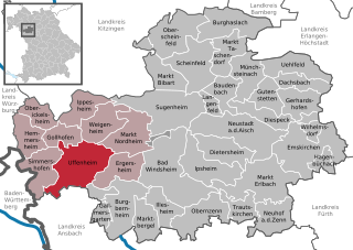
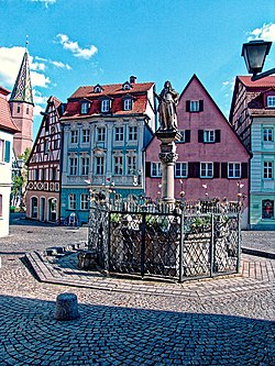
Uffenheim is a city in the Middle Franconian district of Neustadt (Aisch)-Bad Windsheim, in Bavaria, Germany. It is situated 14 km west of Bad Windsheim, and 36 km southeast of Würzburg.

<span class="mw-page-title-main">Bad Berneck im Fichtelgebirge</span> Place in Bavaria, Germany

Bad Berneck im Fichtelgebirge is a spa town in the district of Bayreuth, in Bavaria, Germany. It is situated on the White Main river, in the Fichtel Mountains, 13 km northeast of Bayreuth. It lies in the northern part of the Bavarian province of Upper Franconia. Since 1857 it has been a spa, initially based on its climate and whey products. In 1930 it became a Kneipp spa and, in 1950, a Kneipp health spa.

<span class="mw-page-title-main">Burgbernheim</span> Town in Bavaria, Germany

Burgbernheim is a town in the Neustadt (Aisch)-Bad Windsheim district, in Bavaria, Germany. It is situated 9 km (6 mi) southwest of Bad Windsheim, and 13 km (8 mi) northeast of Rothenburg ob der Tauber. It has a population of around 3,300.

<span class="mw-page-title-main">Fladungen</span> Town in Bavaria, Germany

Fladungen is a town in the Rhön-Grabfeld district, in Bavaria, Germany. It is situated in the Rhön Mountains, 11 km northwest of Ostheim, 20 km west of Meiningen, and 33 km east of Fulda. It is the northernmost town in Bavaria, bordering Hesse to the northwest and Thuringia to the northeast.

<span class="mw-page-title-main">Scheinfeld</span> Town in Bavaria, Germany

Scheinfeld is a town in the Neustadt (Aisch)-Bad Windsheim district, in Bavaria, Germany. It is situated 14 km northwest of Neustadt (Aisch), and 40 km east of Würzburg. Schloss Schwarzenberg is adjacent to the town. The town is home to an Adidas testing factory.

<span class="mw-page-title-main">Ergersheim, Middle Franconia</span> Municipality in Bavaria, Germany

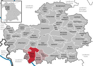
Ergersheim is a municipality in Bavaria, Germany.

<span class="mw-page-title-main">Markt Einersheim</span> Municipality in Bavaria, Germany

Markt Einersheim is a market town and municipality in the district of Kitzingen in Bavaria, Germany. On April 5, 1945, at the end of World War II, the town was bombed by United States Army Air Forces P-47 Thunderbolts. American troops captured the town from German forces, who retreated to the southeast, on April 6.

<span class="mw-page-title-main">Gollhofen</span> Municipality in Bavaria, Germany

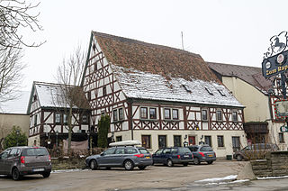
Gollhofen is a municipality in the district of Neustadt (Aisch)-Bad Windsheim in Bavaria in Germany.

<span class="mw-page-title-main">Illesheim</span> Municipality in Bavaria, Germany

Illesheim, founded 1283 AD, is a municipality in the district of Neustadt (Aisch)-Bad Windsheim in Bavaria in Germany. The earliest leader affiliated with Illesheim's foundation was Götz von Berlichingen, known as "the Knight with the Iron Hand." Also known locally as "Illesa". It lies 6 kilometers west of Bad Windsheim and 11 kilometers east of the A7 motorway.

<span class="mw-page-title-main">Markt Bibart</span> Municipality in Bavaria, Germany

Markt Bibart is a market town and municipality in the district of Neustadt (Aisch)-Bad Windsheim in Bavaria in Germany.

<span class="mw-page-title-main">Oberickelsheim</span> Municipality in Bavaria, Germany

Oberickelsheim is a municipality in the district of Neustadt (Aisch)-Bad Windsheim in Bavaria in Germany.

<span class="mw-page-title-main">Oberscheinfeld</span> Municipality in Bavaria, Germany

Oberscheinfeld is a municipalityin the district of Neustadt (Aisch)-Bad Windsheim in Bavaria in Germany.

<span class="mw-page-title-main">Bavarian State Archaeological Collection</span> Central museum of prehistory of the State of Bavaria

The Bavarian State Archaeological Collection in Munich is the central museum of prehistory of the State of Bavaria, considered to be one of the most important archaeological collections and cultural history museums in Germany.

References