An abbess is the female superior of a community of nuns in an abbey.

The Abbey of Saint Gall is a dissolved abbey (747–1805) in a Catholic religious complex in the city of St. Gallen in Switzerland. The Carolingian-era monastery existed from 719, founded by Saint Othmar on the spot where Saint Gall had erected his hermitage. It became an independent principality between 9th and 13th centuries, and was for many centuries one of the chief Benedictine abbeys in Europe. The library of the Abbey is one of the oldest monastic libraries in the world.

Cîteaux Abbey is a Catholic abbey located in Saint-Nicolas-lès-Cîteaux, south of Dijon, France. It is notable for being the original house of the Order of Cistercians. Today, it belongs to the Trappists.
In the Holy Roman Empire, imperial immediacy was the status of an individual or a territory which was defined as 'immediate' to Emperor and Empire and not to any other intermediate authorities, while one that did not possess that status was defined as 'mediate'.

Kempten is the largest town of Allgäu, in Swabia, Bavaria, Germany. The population was about 68,000 in 2016. The area was possibly settled originally by Celts, but was later taken over by the Romans, who called the town Cambodunum. Kempten is the oldest urban settlement (town) in Germany.

Tegernsee is a town in the Miesbach district of Bavaria, Germany. It is located on the shore of Lake Tegernsee, which is 747 m (2,451 ft) above sea level. A spa town, it is surrounded by an alpine landscape of Upper Bavaria, and has an economy mainly based on tourism.

Petershausen Abbey was a Benedictine imperial abbey at Petershausen, now a district of Konstanz in Baden-Württemberg, Germany.

Tegernsee Abbey is a former Benedictine monastery in the town and district of Tegernsee in Bavaria. Both the abbey and the town that grew up around it are named after the Tegernsee, the lake on the shores of which they are located. The name is from the Old High German tegarin seo, meaning great lake.

Irsee Abbey, also the Imperial Abbey of Irsee, was a Benedictine abbey located at Irsee near Kaufbeuren in Bavaria. The self-ruling imperial abbey was secularized in the course of the German mediatization of 1802–1803 and its territory annexed to Bavaria. The buildings of the former abbey now house a conference and training centre for Bavarian Swabia.

Ellwangen Abbey was the earliest Benedictine monastery established in the Duchy of Swabia, at the present-day town of Ellwangen an der Jagst, Baden-Württemberg, about 100 km (60 mi) north-east of Stuttgart.

Baindt Abbey, otherwise the Imperial Abbey of Baindt, was a Cistercian nunnery in Baindt in the district of Ravensburg in Baden-Württemberg, Germany.

Princely abbeys and Imperial abbeys were religious establishments within the Holy Roman Empire which enjoyed the status of imperial immediacy (Reichsunmittelbarkeit) and therefore were answerable directly to the Emperor. The possession of imperial immediacy came with a unique form of territorial authority known as Landeshoheit, which carried with it nearly all the attributes of sovereignty.

Weissenau Abbey was an Imperial abbey (Reichsabtei) of the Holy Roman Empire located near Ravensburg in the Swabian Circle. The abbey, a Premonstratensian monastery, was an Imperial Estate and therefore its abbot had seat and vote in the Reichstag as a prelate of the Swabian Bench. The abbey existed from 1145 until the secularisation of 1802-1803.

Tavistock Abbey, also known as the Abbey of Saint Mary and Saint Rumon, is a ruined Benedictine abbey in Tavistock, Devon. The Abbey was surrendered in 1539 during the Dissolution of the Monasteries. Nothing remains of the abbey except the refectory, two gateways and a porch. The abbey church, dedicated to Our Lady and St Rumon, was destroyed by Danish raiders in 997 and rebuilt under Lyfing, the second abbot. The church was further rebuilt in 1285 and the greater part of the abbey between 1457 and 1458.

Murbach Abbey was a famous Benedictine monastery in Murbach, southern Alsace, in a valley at the foot of the Grand Ballon in the Vosges.

The Princely Abbey of Stavelot-Malmedy, also Principality of Stavelot-Malmedy, sometimes known with its German name Stablo, was an ecclesiastical principality of the Holy Roman Empire. Princely power was exercised by the Benedictine abbot of the imperial double monastery of Stavelot and Malmedy, founded in 651. Along with the Duchy of Bouillon and the Prince-Bishopric of Liège, it was one of only three principalities of the Southern Netherlands that were never part of the Spanish Netherlands, later the Austrian Netherlands, which after 1500 were assigned to the Burgundian Circle while the principalities were assigned to the Lower Rhenish Imperial Circle.

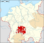
The Princely Abbey of Kempten was an ecclesiastical principality of the Holy Roman Empire for centuries until it was annexed to the Electorate of Bavaria in the course of the German mediatization in 1803.
St. Lorenz Basilica is a baroque minor Basilica in Kempten, Bavaria, named after the Christian martyr Lawrence of Rome. It is the former abbey church of the Benedictine Kempten Abbey. It is currently used as the parish church of the Roman Catholic parish of St. Lawrence in the Diocese of Augsburg.
Konrad von Gundelfingen was prince-abbot of the Princely Abbey of Kempten from 1284 until 1302. He was also anti-abbot of the Princely Abbey of Saint Gall from 1288 until 1291, appointed by King Rudolf I.

Pius Reher was abbot of the benedictine monastery of Saint Gall and prince-abbot of the Princely Abbey of Saint Gall from 1630 until 1654.