You can help expand this article with text translated from the corresponding article in French. (February 2026)Click [show] for important translation instructions.
|
Toul | |
|---|---|
Subprefecture and commune | |
 | |
 Flag  Coat of arms | |
 Location of Toul | |
 Toul  Toul | |
| Coordinates: 48°40′30″N5°53′30″E / 48.675°N 5.8917°E | |
| Country | France |
| Region | Grand Est |
| Department | Meurthe-et-Moselle |
| Arrondissement | Toul |
| Canton | Toul |
| Intercommunality | Terres Touloises |
| Government | |
| • Mayor (2020–2026) | Alde Harmand [1] |
Area 1 | 30.59 km2 (11.81 sq mi) |
| Population (2023) [2] | 15,768 |
| • Density | 515.5/km2 (1,335/sq mi) |
| Time zone | UTC+01:00 (CET) |
| • Summer (DST) | UTC+02:00 (CEST) |
| INSEE/Postal code | 54528 /54200 |
| Elevation | 200–400 m (660–1,310 ft) |
| 1 French Land Register data, which excludes lakes, ponds, glaciers > 1 km2 (0.386 sq mi or 247 acres) and river estuaries. | |
Toul (French pronunciation: [tul] ) is a commune in the Meurthe-et-Moselle department in north-eastern France.
Contents
- Geography
- Climate
- History
- Population
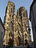
- Sights
- Transportation
- Economy
- Administration
- Twin towns
- Notable people
- Gallery
- See also
- References
- External links
It is a sub-prefecture of the department.