Gerhardshofen | ||
---|---|---|
| ||
Coordinates: 49°37′N10°41′E / 49.617°N 10.683°E Coordinates: 49°37′N10°41′E / 49.617°N 10.683°E | ||
Country | Germany | |
State | Bavaria | |
Admin. region | Mittelfranken | |
District | Neustadt a.d.Aisch-Bad Windsheim | |
Municipal assoc. | Uehlfeld | |
Government | ||
• Mayor | Jürgen Mönius | |
Area | ||
• Total | 27.20 km2 (10.50 sq mi) | |
Elevation | 288 m (945 ft) | |
Population (2017-12-31) [1] | ||
• Total | 2,479 | |
• Density | 91/km2 (240/sq mi) | |
Time zone | CET/CEST (UTC+1/+2) | |
Postal codes | 91466 | |
Dialling codes | 09163 | |
Vehicle registration | NEA | |
Website | www.gerhardshofen.de |
Gerhardshofen is a municipality in the district of Neustadt (Aisch)-Bad Windsheim in the administrative region of Middle Franconia in northern Bavaria in Germany.
Municipalities are the lowest level of official territorial division in Germany. This is most commonly the third level of territorial division, ranking after the Land (state) and Kreis (district). The Gemeinde which is one level lower in those states also includes Regierungsbezirke as an intermediate territorial division. The Gemeinde is one level higher if it is not part of a Samtgemeinde. Only 10 municipalities in Germany have fifth level administrative subdivisions and all of them are in Bavaria. The highest degree of autonomy may be found in the Gemeinden which are not part of a Kreis. These Gemeinden are referred to as Kreisfreie Städte or Stadtkreise, sometimes translated as having "city status". This can be the case even for small municipalities. However, many smaller municipalities have lost this city status in various administrative reforms in the last 40 years when they were incorporated into a Kreis. In some states they retained a higher measure of autonomy than the other municipalities of the Kreis. Municipalities titled Stadt are urban municipalities while those titled Gemeinde are classified as rural municipalities.
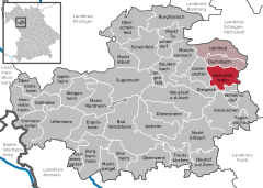
Neustadt (Aisch)-Bad Windsheim is a Landkreis (district) in Bavaria, Germany. It is bounded by the districts of Würzburg, Kitzingen, Bamberg, Erlangen-Höchstadt, Fürth and Ansbach, and by the state of Baden-Württemberg.
A Regierungsbezirk is a type of administrative division in Germany.
Gerhardshofen is located in the valley of the Aisch. The neighbouring municipalities are (from the north in clockwise direction): Dachsbach, Weisendorf, Oberreichenbach, Emskirchen, Diespeck and Gutenstetten. The municipality has 13 boroughs: Altenbuch, Birnbaum, Eckenhof, Emelsdorf, Forst, Göttelhöf, Kästel, Kleehof, Linden, Rappoldshofen, Sintmannsbuch, Vahlenmühle and Willmersbach.
The Aisch is an 83 km long tributary of the Regnitz in Middle- and Upper Franconia, in the state of Bavaria in southern Germany. It passes through Bad Windsheim, Neustadt an der Aisch and Höchstadt, and flows into the Regnitz near Altendorf.
Dachsbach is a so-called "Marktgemeinde", a municipality in the district of Neustadt (Aisch)-Bad Windsheim, in the administrative region of Middle Franconia in northern Bavaria in Germany.
Weisendorf is a municipality in the district of Erlangen-Höchstadt, in Bavaria, Germany. It belongs to the administrative region of Middle Franconia.
The village owes its foundation to the Franconian colonisation of the 9th century and thus is a foundation of the Carolingian dynasty.
The Carolingian dynasty was a Frankish noble family founded by Charles Martel with origins in the Arnulfing and Pippinid clans of the 7th century AD. The dynasty consolidated its power in the 8th century, eventually making the offices of mayor of the palace and dux et princeps Francorum hereditary, and becoming the de facto rulers of the Franks as the real powers behind the Merovingian throne. In 751 the Merovingian dynasty which had ruled the Germanic Franks was overthrown with the consent of the Papacy and the aristocracy, and a Carolingian Pepin the Short was crowned King of the Franks. The Carolingian dynasty reached its peak in 800 with the crowning of Charlemagne as the first Emperor of Romans in the West in over three centuries. His death in 814 began an extended period of fragmentation of the Carolingian empire and decline that would eventually lead to the evolution of the Kingdom of France and the Holy Roman Empire.
The first documented notice of Gerhardshofen is from 1235. There was mentioned a Heinrich Neze von Gerhardshofen in two documents of the Burgraves of Nuremberg. The first non aristocratic inhabitant ever mentioned was Conrad Stahel in 1304.
In the First Margrave War (1449–1450) Nuremberg troops looted 118 cows and 17 horses from Gerhardshofen and Dachsbach.
The First Margrave War from 1449–50 was the result of disputes between the Free Imperial City of Nuremberg and Albrecht III Achilles, Elector of Brandenburg. Numerous towns in Franconia in modern Germany were badly affected by the war.
In 1553 there existed 53 properties which belonged to the manorialism Brunn, the Margraves' bailiff offices of Dachsbach and Neustadt an der Aisch and to the reeves offices of Birkenfeld and Münchsteinach. In the Thirty Years' War nearly all houses were destroyed, also the church was burnt out. But in 1697 there were already 44 farmsteads resettled. Their number increased to 57 in the year 1792.
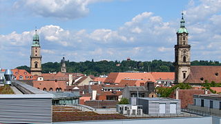
Neustadt an der Aisch is a small town of around 12,000 in the northern part of Bavaria (Germany), within the Franconian administrative region Middle Franconia. It is the district town of the district Neustadt (Aisch)-Bad Windsheim.
Münchsteinach is a municipality in the district of Neustadt (Aisch)-Bad Windsheim in Middle Franconia, Bavaria, Germany.
The Thirty Years' War was a war fought primarily in Central Europe between 1618 and 1648. One of the most destructive conflicts in human history, it resulted in eight million fatalities not only from military engagements but also from violence, famine, and plague. Casualties were overwhelmingly and disproportionately inhabitants of the Holy Roman Empire, most of the rest being battle deaths from various foreign armies. In terms of proportional German casualties and destruction, it was surpassed only by the period January to May 1945; one of its enduring results was 19th-century Pan-Germanism, when it served as an example of the dangers of a divided Germany and became a key justification for the 1871 creation of the German Empire.
The village belonged to the blood court of Dachsbach, but the manoralism Brunn did justice on their properties by their own rights.
Probably there was a church destroyed by 1450. By 1471 there was laid a foundation stone for a new church. The inauguration of it was in 1481. The great structural damages of the Thirty Years' War were not repaired until the end of the 17th century. The renovation of 1795 matched a new construction. It was done in the baroque style of the Margraves. After a recent renovation the Lord's house is a gem in the Aischgrund.
Federal highway B 470 is directed from north to south through the community area.
From 12 July 1904 until 30 May 1976 there was a railway, the Neustadt (Aisch)–Demantsfürth-Uehlfeld railway called Aischtalbahn, which led to the Nuremberg–Würzburg railway. It was broken down and since then only buses connect Dachsbach with the surrounding area. The lines belong to the pay scale area of the Verkehrsverbund Großraum Nürnberg.
Erlangen is a Middle Franconian city in Bavaria, Germany. It is the seat of the administrative district Erlangen-Höchstadt and with 113,752 inhabitants it is the smallest of the eight major cities in Bavaria. The number of inhabitants exceeded the limit of 100,000 in 1974, making Erlangen a major city.
Erlangen-Höchstadt is a Landkreis (district) in Bavaria, Germany. It is bounded by the districts of Fürth, Neustadt (Aisch)-Bad Windsheim, Bamberg, Forchheim and Nürnberger Land, and by the cities of Nuremberg and Erlangen. The city of Erlangen is not part of the district, but nonetheless its administrative seat.
Wiener Neustadt is a city located south of Vienna, in the state of Lower Austria, in north-east Austria. It is a self-governed city and the seat of the district administration of Wiener Neustadt-Land District. The city is the site of one of the world's oldest military academies, the Theresian Military Academy, which was established by Empress Maria Theresa of Austria in 1752 to train officers for the Austrian army.
Ergersheim is a municipality in the Middle Franconian district of Neustadt (Aisch)-Bad Windsheim. Administrative offices are located in Uffenheim.
Dielheim is a municipality in the Rhein-Neckar district of Baden-Württemberg, Germany.
Castell is a municipality in the district of Kitzingen in Bavaria in Germany. It was the seat of the Counts of Castell. Today it is part of the municipal association Wiesentheid. It has around 800 inhabitants.
Neustadt am Main is a community in the Main-Spessart district in the Regierungsbezirk of Lower Franconia (Unterfranken) in Bavaria, Germany and a member of the Verwaltungsgemeinschaft Lohr am Main.
Uehlfeld is a municipality in the district of Neustadt (Aisch)-Bad Windsheim in the administrative region of Middle Franconia in northern Bavaria in Germany.
Wilhelmsdorf is a village in the district of Neustadt (Aisch)-Bad Windsheim in Bavaria in Germany.
Bennhausen is a municipality in the Donnersbergkreis district, in Rhineland-Palatinate, Germany. It belongs to the Verbandsgemeinde of Kirchheimbolanden.
Rutsweiler an der Lauter is an Ortsgemeinde – a municipality belonging to a Verbandsgemeinde, a kind of collective municipality – in the Kusel district in Rhineland-Palatinate, Germany. It belongs to the Verbandsgemeinde Lauterecken-Wolfstein. Rutsweiler an der Lauter is one of two places in the Kusel district named Rutsweiler. The other is Rutsweiler am Glan, lying some 13 km to the west-southwest.
Dexheim is an Ortsgemeinde – a municipality belonging to a Verbandsgemeinde, a kind of collective municipality – in the Mainz-Bingen district in Rhineland-Palatinate, Germany.
Daxlanden is a borough of Karlsruhe, Baden-Württemberg, in the southwest of Germany.
This former fishing village lies west of the city centre of Karlsruhe, not far from the river Rhine on the river Alb and comprises about 12,000 inhabitants.
Leonrod is a village in the borough of the market town of Dietenhofen in the district of Ansbach, Middle Franconia, Germany.
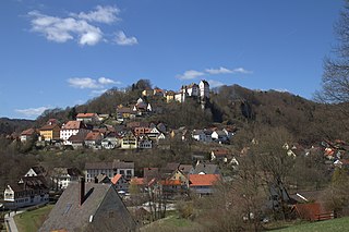
Egloffstein Castle is a former high mediaeval, aristocratic castle, that stands immediately west of the eponymous village of Egloffstein in the Upper Franconian county of Forchheim in the German state of Bavaria.
Thuisbrunn Castle is located centrally within the parish of Thuisbrunn in the municipality of Gräfenberg in the Bavarian province of Upper Franconia. After having been destroyed and rebuilt several times, the castle is now in private ownership.
The burgstall of Dörnhof Castle is the site of a demolished, medieval lowland castle situated at a height of 400 m above sea level (NHN) in the vicinity of Dörnhof Farm near the village of Dörnhof, part of Gräfenberg in the county of Forchheim in the German state of Bavaria.
Schloss Kunreuth is situated on the northwestern edge of the eponymous village of Kunreuth which is part of the collective municipality of Gosberg in the county of Forchheim, in the province of Upper Franconia in the south German state of Bavaria.
Wikimedia Commons has media related to Gerhardshofen . |
This Neustadt (Aisch)-Bad Windsheim location article is a stub. You can help Wikipedia by expanding it. |