Uehlfeld

Last updated
Uehlfeld
Wappen Uehlfeld.png
Coat of arms
Location of Uehlfeld within Neustadt a.d.Aisch-Bad Windsheim district
Uehlfeld in NEA.svg
Germany adm location map.svg
Red pog.svg
Uehlfeld
Bavaria location map.svg
Red pog.svg
Uehlfeld
Coordinates: 49°40′N10°43′E / 49.667°N 10.717°E / 49.667; 10.717 Coordinates: 49°40′N10°43′E / 49.667°N 10.717°E / 49.667; 10.717
Country Germany
State Bavaria
Admin. region Mittelfranken
District Neustadt a.d.Aisch-Bad Windsheim
Municipal assoc. Uehlfeld
Subdivisions13 Ortsteile
Government
   Mayor Werner Stöcker (CSU)
Area
  Total31.23 km2 (12.06 sq mi)
Elevation
278 m (912 ft)
Population
 (2020-12-31) [1]
  Total3,051
  Density98/km2 (250/sq mi)
Time zone UTC+01:00 (CET)
  Summer (DST) UTC+02:00 (CEST)
Postal codes
91486
Dialling codes 09163
Vehicle registration NEA
Website www.uehlfeld.de

Uehlfeld is a municipality in the district of Neustadt (Aisch)-Bad Windsheim in the administrative region of Middle Franconia in northern Bavaria in Germany.

Contents

Geography

Uehlfeld is located in the valley of the Aisch. The neighbouring municipalities are (from the north in clockwise direction): Lonnerstadt, Höchstadt an der Aisch, Weisendorf, Dachsbach, Gutenstetten, Münchsteinach and Vestenbergsgreuth. The municipality has 12 boroughs: Demantsfürth, Egelsbach, Eselsmühle, Gottesgab, Hohenmühle, Nonnenmühle, Peppenhöchstädt, Rohensaas, Schornweisach, Tragelhöchstädt, Voggendorf und Wallmershof.

History

Uehlfeld [2] was probably founded in the 6th century, at the time Francia expanded to the east and so took possession of the Aischgrund. It is likely that one of the seven Slavonian churches founded by Charlemagne within the Aischgrund stood in Uehlfeld.

The first documented notice of Uehlfeld is from 1123. The village was named Oulentevelt. Later the name changed to Ulletenvelt (1127), Uelevelt (1154), Ulfeldium (1158) or Ulefelt (1181).

Like other villages, Uehlfeld was devastated by several great fires. The last of them occurred in 1888.

Wars have left their marks on Uehlfeld. In the German Peasants' War (1524–1525) the village's castle was destroyed. In the Second Margrave War (1552) the boroughs of Nonndorf and Rothenberg were destroyed and were not rebuilt. The Thirty Years' War left its mark with the actions of Colonel Kehraus, [3] whose troops raided and burned the village.

In 1649 Veit-vom-Berg was assigned pastor of the village. He was born in 1612 in Baudenbach. He held his inaugural speech in front of 31 persons (10 men, 15 women and 6 children), the last inhabitants after a time full of privation.

Before Thirty Years' War. Uehlfeld had 600 inhabitants. Veit-vom-Berg died in Uehlfeld in 1675. Today the elementary and secondary schools and a street are named after him. The number of inhabitants did not again reach 600 until the mid-19th century.

During the 19th century many Jewish salesmen came as new citizens to Uehlfeld, so trade and business developed. The Jews built a synagogue, opened a school, and established a graveyard, the tombstones of which are still to be seen today. In 1837 the Jews of Uehlfeld numbered 300, or about half the population, but by 1933, after the anti-semitic campaigns of the Nazi holocaust began, there were only 50 Jewish people left in the town.

The former headmaster of the elementary and secondary schools, Karl Schmer, compiled the history of Uehlfeld into three almanacs, which can be purchased from the municipality office.

Uehlfeld Main road Uehlfeld, Hauptstrasse 55-20160515-001.jpg
Uehlfeld Main road

Local council (Marktgemeinderat)

Election March 2014:

Economics and Infrastructure

Several companies have their head office in Uehlfeld. There are also two breweries, one of them founded in 1639, which makes it the oldest brewery in the Aischgrund.

Federal highway B 470 is directed from north to south through the community area.

From July 12, 1904, until May 30, 1976, there was a railway from Neustadt (Aisch) to Demantsfürth-Uehlfeld called Aischtalbahn which led to the railway Nuremberg Würzburg. It was broken down and since then only busses connect Uehlfeld with the surrounding areas. The lines belong to the pay scale area of VGN.

Related Research Articles

Erlangen Place in Bavaria, Germany

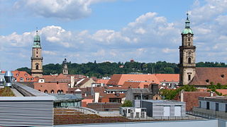
Erlangen is a Middle Franconian city in Bavaria, Germany. It is the seat of the administrative district Erlangen-Höchstadt, and with 113,758 inhabitants, it is the smallest of the eight major cities in Bavaria. The number of inhabitants exceeded the threshold of 100,000 in 1974, making Erlangen a major city.

Neustadt (Aisch)-Bad Windsheim is a Landkreis (district) in Bavaria, Germany. It is bounded by the districts of Würzburg, Kitzingen, Bamberg, Erlangen-Höchstadt, Fürth and Ansbach, and by the state of Baden-Württemberg.

Mattersburg Place in Burgenland, Austria

Mattersburg is a town in Burgenland, Austria. It is the administrative center of the District of Mattersburg and was home to former Bundesliga football team, SV Mattersburg.

Fürth Place in Bavaria, Germany

Fürth is a city in northern Bavaria, Germany, in the administrative division (Regierungsbezirk) of Middle Franconia. It is now contiguous with the larger city of Nuremberg, the centres of the two cities being only 7 km apart.

Neustadt an der Aisch Place in Bavaria, Germany

Neustadt an der Aisch is a small town of around 12,000 in the northern part of Bavaria (Germany), within the Franconian administrative region Middle Franconia. It is the district town of the district Neustadt (Aisch)-Bad Windsheim.

Neustadt an der Weinstraße Place in Rhineland-Palatinate, Germany

Neustadt an der Weinstraße is a town in Rhineland-Palatinate, Germany. With 54,000 inhabitants as of 2002, it is the largest town called Neustadt.

Neustadt am Main Place in Bavaria, Germany

Neustadt am Main is a community in the Main-Spessart district in the Regierungsbezirk of Lower Franconia (Unterfranken) in Bavaria, Germany and a member of the Verwaltungsgemeinschaft Lohr am Main.

Dachsbach Place in Bavaria, Germany

Dachsbach is a market town and municipality in the district of Neustadt (Aisch)-Bad Windsheim, in the administrative region of Middle Franconia in northern Bavaria in Germany.

Gerhardshofen Place in Bavaria, Germany

Gerhardshofen is a municipality in the district of Neustadt (Aisch)-Bad Windsheim in the administrative region of Middle Franconia in northern Bavaria in Germany.

Hainsfarth Place in Bavaria, Germany

Hainsfarth is a municipality in the district of Donau-Ries in Bavaria in Germany.

Becherbach bei Kirn Place in Rhineland-Palatinate, Germany

Becherbach bei Kirn is an Ortsgemeinde – a municipality belonging to a Verbandsgemeinde, a kind of collective municipality – in the Bad Kreuznach district in Rhineland-Palatinate, Germany. It belongs to the Verbandsgemeinde Kirner Land, whose seat is in the town of Kirn. Becherbach bei Kirn should not be confused with Becherbach. Becherbach bei Kirn has borne the tag “bei Kirn” since 1 July 1969, at which time both municipalities found themselves in the same district as a result of administrative reform.

Hennweiler Place in Rhineland-Palatinate, Germany

Hennweiler is an Ortsgemeinde – a municipality belonging to a Verbandsgemeinde, a kind of collective municipality – in the Bad Kreuznach district in Rhineland-Palatinate, Germany. It belongs to the Verbandsgemeinde Kirner Land, whose seat is in the town of Kirn.

Hottenbach Place in Rhineland-Palatinate, Germany

Hottenbach is an Ortsgemeinde – a municipality belonging to a Verbandsgemeinde, a kind of collective municipality – in the Birkenfeld district in Rhineland-Palatinate, Germany. It belongs to the Verbandsgemeinde Herrstein-Rhaunen, whose seat is in Herrstein.

Herchweiler Place in Rhineland-Palatinate, Germany

Herchweiler is an Ortsgemeinde – a municipality belonging to a Verbandsgemeinde, a kind of collective municipality – in the Kusel district in Rhineland-Palatinate, Germany. It belongs to the Verbandsgemeinde of Kusel-Altenglan, whose seat is in Kusel.

Dellmensingen Castle

Dellmensingen Castle is an early Baroque castle in the Upper Swabian village of Dellmensingen, now part of the city of Erbach, in the state of Baden-Württemberg, Germany.

Tragelhöchstädt Ortsteil of Uehlfeld in Bavaria, Germany

Tragelhöchstädt is a village in the municipality of Uehlfeld in the district of Neustadt (Aisch)-Bad Windsheim in Bavaria in Germany.

Leonrod (Dietenhofen) Ortsteil of Dietenhofen in Bavaria, Germany

Leonrod is a village in the borough of the market town of Dietenhofen in the district of Ansbach, Middle Franconia, Germany.

Thuisbrunn Castle

Thuisbrunn Castle is located centrally within the parish of Thuisbrunn in the municipality of Gräfenberg in the Bavarian province of Upper Franconia. After having been destroyed and rebuilt several times, the castle is now in private ownership.

Bieberbach Castle

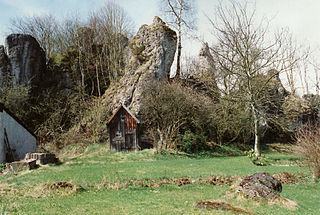
The burgstall or site of Bieberbach Castle is a ruined mediaeval spur castle at a elevation of 530 m above sea level (NN) on a rock formation in the southern part of the parish of Bieberbach, in the market municipality of Egloffstein in the county of Forchheim in the German state of Bavaria.

Unterailsfeld Castle

The burgstall of Unterailsfeld Castle is the site of a medieval lowland castle situated at a height of 360 m above sea level (NHN) in the village of Unterailsfeld, in the market municipality of Gößweinstein in the county of Forchheim in the south German state of Bavaria.

References

  1. "Tabellenblatt "Daten 2", Statistischer Bericht A1200C 202041 Einwohnerzahlen der Gemeinden, Kreise und Regierungsbezirke". Bayerisches Landesamt für Statistik und Datenverarbeitung (in German). June 2021.
  2. History of Uehlfeld
  3. From Kronach to Nördlingen, page 117, footnote 73