The Wetterau, photographed from the western edge between Rosbach and the district Rodheim. The view is oriented to the east; the Nidda flows through the valley in the foreground.
The Wetterau is a fertile undulating tract, watered by the Wetter,[1] a tributary of the Nidda River, in the western German state of Hesse, between the hilly province Oberhessen and the north-western Taunus mountains.
Bettina von Arnim writes of Wetterau in her text Diary of a Child in the chapter "Journey to the Wetterau".
Geography
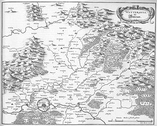
The Wetterau is located north of Frankfurt am Main, on the eastern side of the Taunus and south-west of the Vogelsberg. The main part of the region is taken up by the political region Wetteraukreis. The region got its name from the small creek Wetter, but the region is crossed by several other creeks and rivers - for example, the Nidda, Nidder, Horloff and Usa.
The Wetterau has a long history and is one of the oldest cultural landscapes in Germany. It was always a very fertile region and was populous from as early as the Neolithic Age. Artifacts from successive civilizations that populated the area also exist. Prominent discoveries are tombs from the Bronze Age, Stufe Wölfersheim or from the Celts, Glauberg. Many historical findings are exhibited in the Wetterau-Museum in Friedberg.
The Wetterau was of high strategic relevance for the Roman Empire during its advance into the free Germania. After the end of the Germanic and Gallic wars (58 to 51 BC) a number of Roman forts and roads were built in the Wetterau. A series of fortifications, part of the limes, surrounded the fertile Wetterau region. The region was part of Germania.
The economic power of the Wetterau has increased continuously through specific promotion of its urban centres Frankfurt am Main, Wetzlar, Gelnhausen and Friedberg since Frederick I, Holy Roman Emperor. The cities with their magnificent buildings were important bases for the royal travels and central places for exercising royal rights in the areas of economy and jurisdiction. The economic power was reflected in the right for coinage of the Lords of Hagen-Münzenberg and the urban right to hold markets. Since the 13th century the latter developed into a regular series of fairs in Frankfurt and Friedberg. The Frankfurt Trade Fair still continues this tradition nowadays.
At the end of the Staufer period and with the extinction of the Münzenberg family in 1255 the different political powers of the Wetterau became more obvious, in particular the powerful families in Hanau, Eppstein and Isenburg-Büdingen.
The regional unity of the Wetterau was not primarily a political concept, but rather its result. Since 1422 the late medieval policy initially led to establishment of the estates of the realm, the alliance of knights, and lords and counts of the Wetterau. These supported the development of a regional identity that even survived increasing urban differentiation.
Four stabilizing elements characterize the transition from medieval to modern times in the Wetterau:
Four imperial cities, of which eventually only Frankfurt had significance;
A network of knights and nobility, the Wetterau knighthood, that was concentrated in the imperial castle in Friedberg;
Twenty count lineages that distinguished themselves form the lower gentry;
A number of joint ownerships of cities (Friedberg, Kronberg, Falkenstein, Gelnhausen, Lindheim, Dorheim, Staden, Florstadt); often these were identical with the two groups mentioned before.
The Wetteraukreis is a Kreis (district) in the middle of Hesse, Germany. Neighbouring districts are Landkreis Gießen, Vogelsbergkreis, Main-Kinzig-Kreis, district-free Stadt Frankfurt, Hochtaunuskreis and Lahn-Dill-Kreis.
Gelnhausen is a town, and the capital of the Main-Kinzig-Kreis, in Hesse, Germany. It is located approximately 40 kilometers east of Frankfurt am Main, between the Vogelsberg mountains and the Spessart range at the river Kinzig. It is one of the eleven towns in the district. Gelnhausen has around 22,000 inhabitants.
Büdingen is a town in the Wetteraukreis, in Hesse, Germany. It is mainly known for its well-preserved, heavily fortified medieval town wall and half-timbered houses.
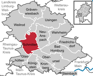
Schmitten im Taunus is a municipality in the Hochtaunuskreis in Hessen, Germany.
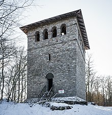
Burgholzhausen vor der Höhe is a quarter of the city of Friedrichsdorf at the foothills of the Taunus mountain range, approx. 20 km (12 mi) north of Frankfurt am Main.
The Grafen von Falkenstein was a dynasty of German nobility descending from the Ministeriales of Bolanden, who held land and a castle at Falkenstein in the Palatinate region.
The Wetter is a 69-kilometre-long (43 mi) river in the state of Hesse, Germany. It is a right tributary to the Nidda which itself is a right tributary of the Main.
Münzenberg Castle is a ruined hill castle in the town of the same name in the Wetteraukreis, Hesse, Germany. It dates from the 12th century. It is one of the best preserved castles from the High Middle Ages in Germany.
The County of Nidda (German: Grafschaft Nidda was a small county of the Holy Roman Empire centred on the city of Nidda in modern Wetteraukreis, Hesse. It was located on the northern edge of the Wetterau river valley and consisted of a relatively cohesive block of land held in fief from the Abbey of Fulda.
The Gießen–Gelnhausen railway is a single-track, non-electrified mainline in the German state of Hesse. It runs from Gießen via Nidda to Gelnhausen.
Wetterau Association of Imperial Counts was an association of comital families in the Wetterau and surrounding areas. It originated in the late Middle Ages and was formally disbanded when the Holy Roman Empire was dissolved in 1806.
Reinhard I, Lord of Hanau is the ancestor of the House of Hanau.
Ulrich I, Lord of Hanau was the ruling Lord of Hanau from 1281 until his death.
Nidda station is a station on the Gießen–Gelnhausen railway in the town of Nidda in the German state of Hesse. It is also at the end of the Beienheim–Schotten railway from Friedberg station. The station is classified by Deutsche Bahn (DB) as a category 4 station.
Büdingen (Oberhess) station is a station on the Gießen–Gelnhausen railway in the town of Büdingen in the German state of Hesse. The station is located in the centre of the town. Büches-Düdelsheim station is also located in the municipality, in the district of Büches. The station is classified by Deutsche Bahn (DB) as a category 5 station.
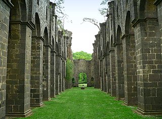
Arnsburg Abbey is a former Cistercian monastery near Lich in the Wetterau, Hesse, Germany. It was founded by monks from Eberbach Abbey in 1174. Although heavily damaged in the Thirty Years' War it was rebuilt later in the 17th century and prospered in the 18th century, when much of the abbey was rebuilt in Baroque style.
Philip III of Falkenstein, Lord of Falkenstein, Münzenberg and Lich, Hesse was a member of the Lich line of the Falkenstein dynasty, son of Werner I of Falkenstein, Lord of Münzenberg and Falkenstein, who founded the Lich line, and his wife Mechtild of Diez.
The Wetterau Limes is the name given in the field of historical research to that part of the Upper Germanic-Rhaetian Limes which enclosed the region that became known later as the Wetterau in the German state of Hesse.
The Friedberg–Mücke railway is a railway that was opened in 1890/97 in the Wetterau and Vogelsberg regions in the German state of Hesse. Sections of the line are also called the Horlofftalbahn and the Seentalbahn. It originally connected three major railways that run from Giessen, namely:
The Beienheim–Schotten railway is a railway in the Horloff and the Nidda valleys in the Wetteraukreis in the German state of Hesse. Its western section is also called the Horlofftalbahn.
This page is based on this Wikipedia article Text is available under the CC BY-SA 4.0 license; additional terms may apply. Images, videos and audio are available under their respective licenses.