
The West Coast District Municipality is a district municipality located in the Western Cape province of South Africa. Its municipality code is DC1. Moorreesburg is the seat of the district. As of 2011, it had a total population of 391,766.

Cederberg Municipality is a local municipality which governs an area of the Western Cape province of South Africa stretching from the Cederberg mountains through the middle valley of the Olifants River to the Atlantic coast. It includes the towns of Clanwilliam, Citrusdal and Lamberts Bay, and the surrounding villages and farms. As of 2011 it had a population of 49,768. It is located within the West Coast District Municipality and its municipality code is WC012.
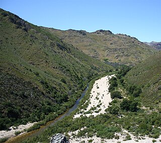
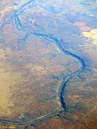
The Olifants River is a river in the northwestern area of the Western Cape Province of South Africa. The upper and main catchment area of the Olifants river is around Ceres and the Cederberg mountains. The Clanwilliam and Bulshoek dams are located on the river and provide water for the towns and farms along the watercourse. The river is approximately 285 km long with a catchment area of 46,220 km2. It flows into the Atlantic Ocean at Papendorp, 250 km north of Cape Town.

Gamtoos River or Gamptoos River is a river in the Eastern Cape Province, South Africa. It is formed by the confluence of the Kouga River and the Groot River and is approximately 645-kilometre (401 mi) long with a catchment area of 34,635 square kilometres (13,373 sq mi).

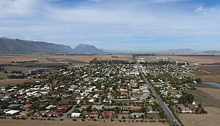
The Berg River is a river located just north of Cape Town in the Western Cape Province of South Africa. It is approximately 294 km (183 mi) long with a catchment area of 7,715 km2 (2979 mi2) and debouches into the Atlantic Ocean. About 65% of the Berg River area is under agriculture. The major towns in the Berg River area are Velddrif and Laaiplek near the coast, Piketberg, Hopefield, Moorreesburg and Darling further inland.
Groot River or Grootrivier, meaning "large river", may refer to:

The Koue Bokkeveld, meaning "Cold Buck Shrubland" in Afrikaans, is a mountain range in the Western Cape Province, South Africa. Geologically the range is composed of Cedarberg Sandstone of the Cape System.
Olifants River is a river in the Klein Karoo area of the Western Cape, South Africa.

The Clanwilliam yellowfish is a ray-finned fish species in the family Cyprinidae. It has long been placed in Barbus, the "wastebin genus" for barbs, by default; however, the species is increasingly being restored to related yellowfish genus Labeobarbus which seems a much more appropriate placement. It is hexaploid like the other yellowfish, among which it is more closely related to the smallscale yellowfish than to the largescale yellowfish.
Porterville is a town in the Western Cape province of South Africa.
The Riet River is a westward-flowing tributary of the Vaal River in central South Africa. In precolonial times the Riet was known as the Gama-!ab, a !Kora name meaning 'muddy'. Its main tributary is the Modder River and after the confluence the Riet River flows westwards to meet the Vaal.

Gourits River, sometimes spelled 'Gouritz River', is situated in the Western Cape, South Africa.

The Motlatse River, Blyde River, or Umdhlazi River is a river in the Mpumalanga and Limpopo provinces of South Africa. It has a northwards course in steep-sided valleys and ravines of the Mpumalanga Drakensberg, before it enters the lowveld region of the Limpopo province. It has its ultimate origins at around 2,000 m altitude in the Hartebeesvlakte conservation area, to the north of Long Tom Pass. It runs through the Blyde River Canyon.

The Levubu River or Levuvhu is located in the northern Limpopo province of South Africa. Some of its tributaries, such as the Mutshindudi River and Mutale River rise in the Soutpansberg Mountains.
The Doring River is a river in the Western Cape Province, South Africa. It is part of the Olifants/Doring River system.

The Bronkhorst Spruit, meaning watercress stream or creek, is a river in the Mpumalanga and Gauteng provinces of South Africa. In the 19th century it as was known as the Kalkoenkransrivier or Rhenosterpoortrivier. It is a tributary of the Wilge River in the Olifants River basin, and it lends its name to the town of Bronkhorstspruit, situated mainly on its right bank.

The Kouga River originates near Uniondale, Eastern Cape, South Africa, and flows eastward, where it joins the Groot River to form the Gamtoos just past the Kouga Dam. Its main tributary is the Baviaanskloof River, which joins its left bank before the dam.

The Letaba River, also known as Leţaba, Lehlaba or Ritavi, is a river located in eastern Limpopo Province, South Africa. It is one of the most important tributaries of the Olifants River.

The Groot River is a river in the southern area of the Western Cape province of South Africa. It is a right hand tributary of the Gourits River.
The Riet River is a river in the Western Cape Province, South Africa. It is part of the Olifants/Doring River system.
