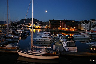
Florø (help·info) is a town and the administrative centre of Flora Municipality in Sogn og Fjordane county, Norway. The town was founded by royal decree in 1860 as a ladested on the island of Florelandet, located between the Botnafjorden and Solheimsfjorden. Florø is Norway's westernmost town—west of Amsterdam, Brussels, and Nice. It is the most western town on the mainland in the Nordic countries.

Bruland is a farming village located about 3.5 kilometres (2.2 mi) east of the town of Førde in the municipality of Førde in Sogn og Fjordane county, Norway. The population (2001) of Bruland was 212. It is located just south of the river Jølstra, along the European route E39 highway. The lake Holsavatnet is located about 10 kilometres (6.2 mi) east of Bruland and the small Moskog area lies at the western end of that island. The name of the hamlet, Bruland literally means "land of bridges". Historically, many of the people who worked on the local farm took the surname Bruland.
Norddalsfjord Bridge is a cantilever bridge that crosses the Norddalsfjorden in the municipality of Flora in Sogn og Fjordane county, Norway. It is the only road (non-ferry) that connects Bremanger municipality to the rest of the mainland. The bridge is 401 metres (1,316 ft) long, and the longest span is 230 metres (750 ft). The bridge was opened in 1987. It is located about 15 kilometres (9.3 mi) east of the town of Florø, 2.5 kilometres (1.6 mi) north of the village of Grov, and about 3 kilometres (1.9 mi) west of the village of Norddalsfjord.

Grov or Grovfjord is a village in Skånland Municipality in Troms county, Norway. The village is located 12 km (7.5 mi) east of the village of Tovik along the Grovfjorden at a very narrow point in the fjord. It is about 60 km (37 mi) southeast of the town of Harstad and about 71 km (44 mi) west of the town of Narvik. The Moelva and Gårdselva rivers flow through the village into the fjord. The 0.58-square-kilometre (140-acre) village has a population (2017) of 400 which gives the village a population density of 690 inhabitants per square kilometre (1,800/sq mi).
Brandsøy (Brandsoy) is a village in the municipality of Flora in Sogn og Fjordane county, Norway. It is located on both sides of small strait that separates the east end of the island of Brandsøya and the mainland. The village sits along the Norwegian National Road 5 highway, about 6.9 kilometres (4.3 mi) east of the town of Florø and about 10 kilometres (6.2 mi) west of the village of Grov. The 0.4-square-kilometre (99-acre) village has a population (2013) of 420, giving the village a population density of 1,337 inhabitants per square kilometre (3,460/sq mi).

Tysdalsvatnet or Tyssdalsvatnet is a lake in the municipalities of Hjelmeland and Strand in Rogaland county, Norway. The 3.74-square-kilometre (1.44 sq mi) lake lies about 5 kilometres (3.1 mi) south of the village of Årdal and about 8 kilometres (5.0 mi) east of the village of Tau. The Norwegian National Road 13 (Rv13) runs along the northern side of the lake. The Svo Tunnel was completed in 2013 and it routes much of Rv13 through a mountain rather than along the narrow shoreline of the lake.

Kilefjorden is a lake on the border of Aust-Agder and Vest-Agder counties in Norway. The lake is located on the border of the municipalities of Evje og Hornnes and Iveland and Vennesla. The lake is part of the river Otra. The lake is located about 6 kilometres (3.7 mi) west of the village of Birketveit in Iveland, about 2.5 kilometres (1.6 mi) north of the village of Hægeland in Vennesla, and about 15 kilometres (9.3 mi) south of the village of Hornnes in Evje og Hornnes.

Askrova is an island in the municipality of Flora in Sogn og Fjordane county, Norway. It is located along the Brufjorden, near the mouth of the Førdefjorden, about 4 kilometres (2.5 mi) northwest of the island of Svanøya. Askrova sits about 7 kilometres (4.3 mi) southwest of the town of Florø and about the same distance southeast of the island of Reksta. The population of the 7.8-square-kilometre (3.0 sq mi) island (2001) was 143, with most residents living on the south and west shores of the island. The 219-metre (719 ft) tall mountain Skara is the highest point on the island. Askrova Chapel is located on the island.
Endestadvatnet is a lake in the municipality of Flora in Sogn og Fjordane county, Norway. The lake is located about 8 kilometres (5.0 mi) east of the village of Eikefjord and 5 kilometres (3.1 mi) west of the lake Emhjellevatnet in neighboring Gloppen municipality.

Holsavatnet is a lake which lies in the municipality of Førde in Sogn og Fjordane county, Norway. The lake is located about 12 kilometres (7.5 mi) east of the town of Førde and about 9.5 kilometres (5.9 mi) east of the village of Bruland. The village of Holsen lies at the eastern end of the lake. The European route E39 highway passes 3 kilometres (1.9 mi) west of the lake. The lake eventually flows into the river Jølstra.
Nyttingnes is a hamlet with 28 inhabitants and 9 houses in the municipality of Flora in Sogn og Fjordane county, Norway. Nyttingnes is located 6 kilometres (3.7 mi) northwest of the village of Steinhovden and about 3 kilometres (1.9 mi) across the fjord from the village of Brandsøy. The town of Florø lies about 8 kilometres (5.0 mi) to the west, although the road from Nyttingnes to Florø goes around the fjord via the village of Eikefjord. In recent history, there has been a negative demographic trend in this village. Nyttingnes is made up of the farms: Tunet, Bakken, Pergarden, Ludviggarden, Kvia, Opptun and Rabbane. Historically, the inhabitants were farmers and fishermen. The nearby Skårafjæra beach area is popular for many tourists.
Rognaldsvåg is a fishing village in the municipality of Flora in Sogn og Fjordane county, Norway. It is located on the western end of the island of Reksta, less than 1 kilometre (0.62 mi) east of the island of Kinn and about 2 kilometres (1.2 mi) south of the island of Skorpa. The town of Florø is located about 10 kilometres (6.2 mi) to the east and the island of Askrova is 8 kilometres (5.0 mi) to the southeast. The small village has about 80 residents. The village has two ports with a distinctive channel between them where boathouses are close together. Rognaldsvåg is rich in ambience and cultural heritage with cemeteries and ruins from the Viking Age.
Steinhovden is a village with 119 inhabitants in the municipality of Flora in Sogn og Fjordane county, Norway. The village is located along the Høydalsfjorden, about 6 kilometres (3.7 mi) southeast of the village of Nyttingnes and about 10 kilometres (6.2 mi) west of the village of Eikefjord. The village area is divided into 6 farm areas: Seljeset, Høyvik, Holmesund, Steinhovden, Steinvik and Hopen. The chairman of the area is now trying to get a windmill park built to produce electrical energy for the community. The nearby Skårafjæra area is a popular place for tourists. The hunting season begins 11 September and hunters may go after deer, seal, and whales.
Renså is a small village in Skånland Municipality in Troms county, Norway. It is located just east of the slightly larger village of Tovik, and about 4 km (2.5 mi) east of the village of Sandstrand. The population (2001) of Renså is 69. The village is located next to the Rensåelva river which flows into the Astafjorden from the Rensåvatnet lake. The nearest larger village is Grov, about 11 km (6.8 mi) to the east.
Reksta is an island in the municipality of Flora in Sogn og Fjordane country, Norway. The 5.8-square-kilometre (2.2 sq mi) island lies about 7 kilometres (4.3 mi) west of the town of Florø in a large group of inhabited islands. Reksta sits about 600 metres (2,000 ft) east of the island of Kinn, about 5 kilometres (3.1 mi) north of the island of Askrova, and about 1.4 kilometres (0.87 mi) south of the island of Skorpa. Most of the inhabitants on Reksta live on the west side in and around the small fishing village of Rognaldsvåg. The population of the island (2001) is 144.
Eimhjellevatnet or Emhjellevatnet is a lake in Hyen area of Gloppen Municipality in Sogn og Fjordane county, Norway. The 11.39-square-kilometre (4.40 sq mi) lake is located in the western part of the municipality near the border with Flora Municipality. The villages of Eimhjellen and Solheim can be found along its shore and the village of Straume lies about 15 kilometres (9.3 mi) to the north. The lake lies about 25 kilometres (16 mi) southwest of the municipal center of Sandane. It is the second largest lake in all of Gloppen municipality and it has a good population of trout for fishing.

Hovden or Barekstadlandet is an island in the municipality of Flora in Sogn og Fjordane county, Norway. The 14.6-square-kilometre (5.6 sq mi) island lies about 10 kilometres (6.2 mi) northwest of the town of Florø and about 6 kilometres (3.7 mi) south of the village of Kalvåg on the island of Frøya in neighboring Bremanger municipality, across the Frøysjøen strait. Most of the 68 inhabitants live along the eastern coast of the island. Kvanhovden Lighthouse is located on the northwestern shore of the island. The island is very rocky, mountainous, and barren. The highest point on the island is the 310-metre (1,020 ft) tall mountain Store Skorekinna.

Norddal or Norddalsfjord is a village in Flora Municipality in Sogn og Fjordane county, Norway. The village lies along the Norddalsfjorden at the entrance to the Solheimsdalen valley. It sits at the mouth of the Norddalselva river on a small peninsula that sticks out into the fjord. The village lies along Norwegian County Road 544 about 25 kilometres (16 mi) east of the town of Florø, and about 4 kilometres (2.5 mi) northeast of the Norddalsfjord Bridge. Nordal Church is located in the small village, serving the northeastern part of the municipality.

Eikefjord is a village in Flora Municipality in Sogn og Fjordane county, Norway. The village is located at the end of the Eikefjorden along the Norwegian National Road 5 highway. The town of Florø lies about 30 kilometres (19 mi) to the west and the village of Naustdal lies about 20 kilometres (12 mi) to the southeast (through the Naustdal Tunnel. The lake Endestadvatnet lies about 5 kilometres to the east. The villages of Nyttingnes and Steinhovden lie about 15 kilometres west of Eikefjord. The 0.4-square-kilometre village has a population of 368, giving the village a population density of 920 inhabitants per square kilometre.


