Mato Grosso is one of the states of Brazil, the third-largest by area, located in the western part of the country.

Cocalzinho de Goiás is a municipality in central Goiás state, Brazil.

Chapada dos Veadeiros National Park is a national park of Brazil located in the state of Goias, on the top of an ancient plateau with an estimated age of 1.8 billion years. The park was created on January 11, 1961 by President Juscelino Kubitscheck, and listed as a World Heritage Site by Unesco in 2001. It occupies an area of 655 square kilometres (253 sq mi) in the municipalities of Alto Paraíso de Goiás, Cavalcante and Colinas do Sul. The park is maintained by Chico Mendes Institute for Biodiversity Conservation.
The Gruta das Mercês is a cave located along the Canada das Mercês, situated in the civil parish of Feteira, municipality of Angra do Heroísmo, in the Portuguese archipelago of the Azores.
Gruta das Agulhas is a cave located along the promontory of Ponta dos Coelhos, in the Bay of Refugo, in the civil parish of Porto Judeu, in the municipality of Angra do Heroísmo, the Portuguese archipelago of the Azores.
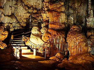
Caverna da Tapagem (SP-002), also Caverna do Diabo, is a cave located within the Jacupiranga State Park next to the Alto Ribeira Tourist State Park, in the municipality of Eldorado Paulista, Iporanga, 280 km from São Paulo, Brazil. It is the second longest cave in the state of São Paulo and also the highlight of what the local guides call "Circuit Disneyland," which is a series of family attractions that people of all ages can enjoy.

Gruta de Maquiné (MG-0243), also Lapa Nova de Maquiné, is the oldest and one of the most commercially visited caves in Brazil. It is located about 5 km (3.1 mi) from Cordisburgo and 143 km (88.9 mi) northwest of Belo Horizonte, in the State of Minas Gerais. The cave has seven huge chambers explored, amounting to 650 m (2,130 ft) (linear) and unevenness of the ground of only 18 m (59 ft). Safety measures like lighting, walkways and handrails allow a multitude of visitors to enjoy safely the wonders of the grotto where the whole journey is accompanied by an experienced local guide.
Guy Christian Collet was a French scientist, explorer and spelunker who came to live in Brazil after the World War II. In the karstic region along the Ribeira valley in the State of Sao Paulo he began the exploration for caverns and grottos, becoming later founder and chairman of two speleological societies of deep respectability in the field of speleology in the country. He did work in the areas of underground biology, archeology, nutrition techniques in caves, besides having published several books and reports on the subject.
Gruta Casa de Pedra (SP-009) is a cave located in the karstic region of the Alto Ribeira Tourist State Park, between the municipalities of Apiaí and Iporanga, to the south of the State of Sao Paulo, Brazil. It is 2,930 meters long and features the largest cave mouth in the world, measuring 172 meters high. It is located in the final portion of the hydrographic sub-basin of the Maximiano stream which enters the cave for about 800 meters and flows into the Iporanga River. Its name derives from the size of its portico, recognized as the world's largest.
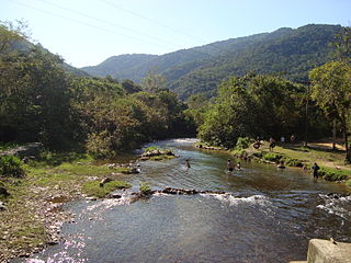
The Alto Ribeira Tourist State Park is a state park is the state of São Paulo, Brazil. It protects a mountainous area of Atlantic Forest. It is known for its many caves.
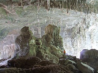
Caverna de Santana (SP-041), also Caverna de Sant'Anna, is a cave located inside the Alto Ribeira Tourist State Park, along the road connecting the towns of Apiaí and Iporanga, to the south of the State of Sao Paulo, Brazil. The Flowers' Hall, displaying thousands of flowers of aragonite, and the Taqueupa Hall as one of the many other formations of great scenic beauty found in the cave, are ranked among the most beautiful and ornated of the world.
Pierre Martin was a French engineer and spelunker who enormously contributed to mapping and researching of a multitude of caves in the states of São Paulo, Goias and Bahia, in Brazil. He was one of the founders and president of the Brazilian Speleology Society (SBE). He died in a car accident on 21 December 1986.
Abismo Ouro Grosso (SP-054), also Gruta Ouro Grosso, is a 192-metre-deep (630 ft) shaft consisting of waterfalls and natural pools. It was created by the capture of surface rivers by carbonate rocks with subterranean drainage systems in an advanced stage of evolution. First explored by the German naturalist and spelunker Michel Le Bret in the 1970s, it is located at the Nucleo Ouro Grosso, within the borders of the Alto Ribeira Tourist State Park, in the municipality of Iporanga, 350 kilometres (220 mi) from Sao Paulo, Brazil.
Areado Grande is the name given to a group of limestone caves located inside the Alto Ribeira Tourist State Park, in the municipality of Iporanga, State of Sao Paulo, Brazil. It consists of Areado Grande I (SP-077), Areado Grande II (SP-078) being 3400 meters long, Areado Grande III (SP-510) with 6004 linear meters, Areado Grande IV (SP-524), Areado Grande V (SP-525). Other caves in the region of the Areado Grande creek are Toca da Pedra Inclinada, Gruta do Toboga, Gruta do Jeep (SP-086), Gruta da Fenda (SP-087), Gruta do Baixao (SP-088), and Gruta da Cabana (SP-108).

