
Wapienno is a village in the administrative district of Gmina Barcin, within Żnin County, Kuyavian-Pomeranian Voivodeship, in north-central Poland. It lies approximately 3 kilometres (2 mi) south-east of Barcin, 19 km (12 mi) east of Żnin, and 32 km (20 mi) south of Bydgoszcz.
Nowe Masiewo is a village in the administrative district of Gmina Narewka, within Hajnówka County, Podlaskie Voivodeship, in north-eastern Poland, close to the border with Belarus. It lies approximately 10 kilometres (6 mi) east of Narewka, 25 km (16 mi) north-east of Hajnówka, and 59 km (37 mi) south-east of the regional capital Białystok.
Rożniatów is a village in the administrative district of Gmina Uniejów, within Poddębice County, Łódź Voivodeship, in central Poland. It lies approximately 9 kilometres (6 mi) north of Uniejów, 19 km (12 mi) north-west of Poddębice, and 53 km (33 mi) north-west of the regional capital Łódź.
Chrząszczew is a village in the administrative district of Gmina Biała Rawska, within Rawa County, Łódź Voivodeship, in central Poland. It lies approximately 6 kilometres (4 mi) north-west of Biała Rawska, 15 km (9 mi) north-east of Rawa Mazowiecka, and 67 km (42 mi) east of the regional capital Łódź.
Kurzeszynek is a village in the administrative district of Gmina Rawa Mazowiecka, within Rawa County, Łódź Voivodeship, in central Poland. It lies approximately 8 kilometres (5 mi) north of Rawa Mazowiecka and 57 km (35 mi) east of the regional capital Łódź.
Dąbrowica is a village in the administrative district of Gmina Słupia, within Jędrzejów County, Świętokrzyskie Voivodeship, in south-central Poland. It lies approximately 11 kilometres (7 mi) south-west of Słupia, 34 km (21 mi) west of Jędrzejów, and 66 km (41 mi) south-west of the regional capital Kielce.
Kępa Chwałowska is a village in the administrative district of Gmina Dwikozy, within Sandomierz County, Świętokrzyskie Voivodeship, in south-central Poland. It lies approximately 5 kilometres (3 mi) north-east of Dwikozy, 11 km (7 mi) north-east of Sandomierz, and 87 km (54 mi) east of the regional capital Kielce.
Kolonia Gałkowice is a village in the administrative district of Gmina Dwikozy, within Sandomierz County, Świętokrzyskie Voivodeship, in south-central Poland. It lies approximately 6 kilometres (4 mi) west of Dwikozy, 8 km (5 mi) north of Sandomierz, and 79 km (49 mi) east of the regional capital Kielce.
Krusz is a village in the administrative district of Gmina Glinojeck, within Ciechanów County, Masovian Voivodeship, in east-central Poland. It lies approximately 6 kilometres (4 mi) east of Glinojeck, 19 km (12 mi) west of Ciechanów, and 81 km (50 mi) north-west of Warsaw.
Piekiełko is a village in the administrative district of Gmina Grójec, within Grójec County, Masovian Voivodeship, in east-central Poland.
Anielin is a village in the administrative district of Gmina Belsk Duży, within Grójec County, Masovian Voivodeship, in east-central Poland.
Makówiec Mały is a village in the administrative district of Gmina Dobre, within Mińsk County, Masovian Voivodeship, in east-central Poland. It lies approximately 6 kilometres (4 mi) east of Dobre, 22 km (14 mi) north-east of Mińsk Mazowiecki, and 53 km (33 mi) east of Warsaw.
Antoniewo is a village in the administrative district of Gmina Ostrów Mazowiecka, within Ostrów Mazowiecka County, Masovian Voivodeship, in east-central Poland.
Rząśnik-Majdan is a village in the administrative district of Gmina Wąsewo, within Ostrów Mazowiecka County, Masovian Voivodeship, in east-central Poland. It lies approximately 13 kilometres (8 mi) west of Ostrów Mazowiecka and 85 km (53 mi) north-east of Warsaw.
Rzeszotary-Zawady is a village in the administrative district of Gmina Rościszewo, within Sierpc County, Masovian Voivodeship, in east-central Poland.
Józefowo is a village in the administrative district of Gmina Rząśnik, within Wyszków County, Masovian Voivodeship, in east-central Poland. It lies approximately 6 kilometres (4 mi) north of Rząśnik, 19 km (12 mi) north of Wyszków, and 64 km (40 mi) north of Warsaw.
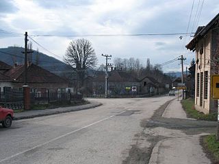
Oparić is a village in Central Serbia, in the municipality of Rekovac. The village has around 1260 residents. It lies at 43°45′00″N21°07′11″E, at the altitude of 295 m. The Oparić is well known as birthplace of naive artist Janko Brašić.
Kozłowo is a village in the administrative district of Gmina Trzemeszno, within Gniezno County, Greater Poland Voivodeship, in west-central Poland. It lies approximately 5 kilometres (3 mi) west of Trzemeszno, 12 km (7 mi) north-east of Gniezno, and 60 km (37 mi) east of the regional capital Poznań.
Ceglarki is a village in the administrative district of Gmina Bartoszyce, within Bartoszyce County, Warmian-Masurian Voivodeship, in northern Poland, close to the border with the Kaliningrad Oblast of Russia.
Maronie is a village in the administrative district of Gmina Łukta, within Ostróda County, Warmian-Masurian Voivodeship, in northern Poland. It lies approximately 4 kilometres (2 mi) north-east of Łukta, 18 km (11 mi) north-east of Ostróda, and 27 km (17 mi) west of the regional capital Olsztyn.


