
The Community of Madrid is one of the seventeen autonomous communities of Spain. It is located in the centre of the Iberian Peninsula, and of the Central Plateau. Its capital and largest municipality is the City of Madrid, which is also the capital of the country. The Community of Madrid is bounded to the south and east by Castilla–La Mancha and to the north and west by Castile and León. It was formally created in 1983, in order to address the particular status of the City of Madrid as the national capital city and in urban hierarchy. Its limits are those of the province of Madrid, which was until then conventionally included in the historical region of New Castile.

Castilla–La Mancha is an autonomous community of Spain. Comprising the provinces of Albacete, Ciudad Real, Cuenca, Guadalajara and Toledo, it was created in 1982. The government headquarters are in Toledo, which is the capital de facto.

The Manzanares is a river in the centre of the Iberian Peninsula, which flows from the Sierra de Guadarrama, passes through Madrid, and eventually empties into the Jarama river, which in turn is a right-bank tributary to the Tagus.

Guadarrama is a town and municipality in the Cuenca del Guadarrama comarca, in the Community of Madrid, Spain.

Villanueva de la Cañada is a municipality in the Community of Madrid, Spain. Located 30 km north-west from Madrid, the municipality covers an area of 34.92 km2. Geographically, it sits on a large plain, in which there are several promontories, on one of which is found the castle of Aulencia, its main landmark. The ESA's European Space Astronomy Centre lies close to the former, on the Guadarrama riverfront. Villafranca del Castillo, a well-off urban area detached from the main nucleus, is located within the municipal bounds. Villanueva de la Cañada hosts the main campus of the Alfonso X El Sabio University as well as the Aquópolis waterpark.
Soto del Real, whose former name was Chozas de la Sierra, is a town and municipality in the northern area of the autonomous Community of Madrid which had 9,188 inhabitants in 2022.

Puertollano is a municipality of Spain located in the province of Ciudad Real, Castile-La Mancha. The city has a population of 45,539 (2022). Contrasting to the largely rural character of the region, Puertollano stands out for the importance of industry, with a past linked to industrial and mining activities. It lies on the AVE high-speed train line linking Madrid and Seville.

San Sebastián de los Reyes is a municipality in the Community of Madrid, Spain. Founded in 1492, it is located 20 kilometres (12 mi) north of Madrid.

Colmenar Viejo is a town and municipality of about 48,614 inhabitants, located in the Community of Madrid, Spain, 30 kilometers north of Madrid on the M-607 motorway. It belongs to the comarca of Cuenca Alta del Manzanares.

The Sierra de Guadarrama is a mountain range forming the main eastern section of the Sistema Central, the system of mountain ranges along the centre of the Iberian Peninsula. It is in Spain, between the systems Sierra de Gredos in the province of Ávila, and Sierra de Ayllón in the province of Guadalajara.

San Agustín del Guadalix is a Spanish town located north of the Comunidad de Madrid, near to Sierra de Guadarrama.
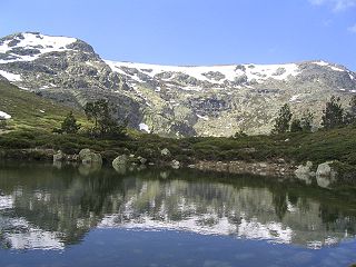
Sierra de Guadarrama National Park is a national park in Spain, covering nearly 34,000 hectares, the fifth largest in Spain's national parks system. The Guadarrama mountain range contains some ecologically valuable areas, located in the Community of Madrid and Castile and León. The law that regulates the recently approved national park was published in the BOE in June 26, 2013.
The Toloño, also known as the Sierra de Cantabria, is a mountain range in the province of Álava in the Basque Country in northern Spain.

Cerro de Gorría is a 1.708 metres high mountain in Spain.

The Sierra del Ocejón or Sierra del Robledal is a mountain range located in the central part of the Iberian Peninsula.

Somosierra is a municipality in the Community of Madrid, Spain, located at 83 km north of Madrid, in the mountain pass with the same name, at an elevation of 1433 metres above sea level, being the northernmost town of Community of Madrid. The Battle of Somosierra was fought here in 1808 during the Napoleonic Wars, and the Battle of Guadarrama was fought nearby in 1936 during the Spanish Civil War.

The Guadiela is a river in the Iberian Peninsula, a left-bank tributary of the Tagus and the latter's major upper-course tributary.

La Maliciosa is one of the most important and highest mountains of the Sierra de Guadarrama, a mountainous formation belonging to the Sistema Central. It has an altitude of 2227m above sea level and is located in the northwest of the Community of Madrid, in Spain, rising between La Pedriza, which lies to the east, and La Barranca valley, which is on its western slope.

The Cuenca Alta del Manzanares Regional Park, created in 1985, is the natural space protected area with the largest extension in the Community of Madrid (Spain) and one of the most ecologically and scenically valuable. It is located in the northwest of the region and extends around the upper course of the Manzanares River, along 42 583 ha. Its main municipalities of reference are Manzanares el Real and Hoyo de Manzanares. Unesco declared it a Biosphere Reserve in 1992.

